Old Maps of Tim Pond Township, Maine for Genealogy
Trace your family roots with 38 historic maps of Tim Pond Township. These high-res maps reveal old neighborhoods, homesites, landmarks, and streets — helping you uncover where your ancestors lived and how the area evolved over time.
- Explore historic neighborhoods: Identify where your relatives may have lived in the 1800s or 1900s.
- Compare maps over time: Trace the changes in streets, buildings, and landmarks for multi-generational research.
- Perfect for genealogy & ancestry research: Used by family historians and researchers to map out lineage and migration.
These maps are an incredible resource for exploring your personal connection to Tim Pond Township's past.
Tim Pond Township, ME maps
(38)- 1932 Map of Kennebago Lake
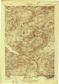 1932 Kennebago Lake1932 Print · USGSThe Franklin County backcountry in the early thirties is a landscape of isolated timber camps and mountain lakes. Researchers can locate remote industrial sites like Langtown Mill, rural schoolhouses such as Dallas Sch, and the rail-linked Dead River Sta.4 unique versions available
 - 1935 Map of Kennebago Lake
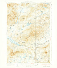
 1935 Kennebago Lake1935 Print · USGSFranklin County's timberlands and sporting camps are preserved here as they were in the mid-1930s. Researchers can locate remote schools and industry sites like Langtown Sch and Langtown Mill, or trace the historic Arnold Trail north toward the border.
 - 1936 Map of Kennebago Lake
 1936 Kennebago Lake1936 Print · USGSThe North Woods of Maine are shown in the mid-1930s, as traditional logging and sporting life persisted around Kennebago Lake. Genealogists and historians can trace isolated schoolhouses like the Kennebago School and old local landmarks such as Langtown Mill.3 unique versions available
 - 1949 Map of Jackman
 1949 Jackman1949 Print · USGSThe Quebec and Maine borderlands are shown in great detail during the late 1940s, highlighting the industrial and natural geography of the region. Trace old rail lines like the Canadian Pacific and locate settlements from Sherbrooke to Scotstown.2 unique versions available
 - 1963 Map of Jackman
 1963 Jackman1963 Print · USGSThe international borderlands of Maine and Quebec come alive in the mid-twentieth century, showing a landscape of timber towns and rail connections. Genealogists and historians can trace the paths of the Canadian Pacific Railway through Jackman or locate families in Sherbrooke and Megantic.
 - 1966 Map of Sherbrooke
 1966 Sherbrooke1966 Print · USGSThe borderlands of Quebec and Maine come alive in the mid-1960s, documenting the industrial towns and deep woods of the Northeast. Genealogists can trace family lines through Sherbrooke and Coaticook, or locate remote logging outposts along the Moose River and Flagstaff Lake.
 - 1969 Map of Black Mountain, 1973 Print
 1969 Black Mountain1973 Print · USGSFranklin County's remote northern townships are documented here during the late sixties, showing a landscape defined by timber and high peaks. Genealogists and researchers can trace the remote logging roads and waterways around Tim Pond, Black Mtn, and the various branches of Alder Stream.2 unique versions available
 - 1969 Map of Quill Hill, 1973 Print
 1969 Quill Hill1973 Print · USGSFranklin County's mountain wilderness is captured in the late sixties, showing a landscape defined by timber and remote outposts. Trace the isolated Kennebago Settlement, the historic Langtown Mill, and family sites like Green Farm.
 - 1970 Map of Kennebago Lake, 1973 Print
 1970 Kennebago Lake1973 Print · USGSNorthwestern Maine at the start of the 1970s remained a landscape of sporting camps and timber townships. Genealogists and researchers can trace the remote outposts of Grants Camps and Kennebago Lake Camps among the peaks of East Kennebago Mtn.
 - 1970 Map of Tim Mountain, 1973 Print
 1970 Tim Mountain1973 Print · USGSThe Franklin County highlands in the early 1970s show a remote landscape of timber townships and sporting camps. Researchers can locate remote outposts like Tim Pond Camp, trace the winding Tim Pond Lookout Road, and explore the high peaks of the Barnard Mountains.
 - 1976 Map of Sherbrooke
 1976 Sherbrooke1976 Print · USGSThe northern Maine woods and Quebec’s Eastern Townships meet in this mid-century survey of the rugged international borderlands. Genealogists and historians can trace rail-and-river connections through Thetford Mines, follow the Dead River to Flagstaff Lake, or locate small border crossings at Stanhope and Beecher Falls.2 unique versions available
 - 1977 Map of Kennebago Lake, 1983 Print
 1977 Kennebago Lake1983 Print · USGSThe Maine wilderness of the late seventies is captured in this orthophoto, showing the unpopulated mountain landscapes near Loon Lake. Researchers can trace the drainages of Big Sag Brook and the high ridges of Spotted Mountain.
 - 1977 Map of Black Mountain, 1983 Print
 1977 Black Mountain1983 Print · USGSFranklin County's high timberlands are captured in detail during the late seventies, showing the area's transition into the winter season. Genealogists and outdoorsmen can trace the drainage of North Branch Alder Stream and identify sites near Tim Pond.
 - 1977 Map of Tim Mountain, 1983 Print
 1977 Tim Mountain1983 Print · USGSMaine's timberlands are revealed in this late-seventies aerial survey of the Franklin County wilderness. Study the undisturbed drainages of Alder Stream and Tim Brook or locate the remote waters of Tim Pond at the foot of Tim Mountain.
 - 1977 Map of Quill Hill, 1983 Print
 1977 Quill Hill1983 Print · USGSThe Maine timberlands and the upper reaches of the South Branch Dead River are captured in this late-seventies aerial survey. Genealogists and local historians can pinpoint the exact locations of the Kennebago Settlement and Langtown Mill amidst the forest.
 - 1986 Map of Flagstaff Lake
 1986 Flagstaff Lake1986 Print · USGSThe Maine North Woods and the Dead River valley are captured here in the mid-1980s, an era of established hydroelectric lakes and outdoor recreation. Genealogists and researchers can trace the vicinity of Kennebago Settlement, Langtown Mill, and the villages of Stratton and Eustis.
 - 1994 Map of Flagstaff Lake
 1994 Flagstaff Lake1994 Print · USGSThe Maine wilderness and the Quebec border come alive in this mid-nineties survey of the Dead River country. Researchers can trace the Appalachian Trail over Bigelow Mountain and locate remote sites like Kennebago Settlement.
 - 1997 Map of Kennebago Lake, 2000 Print
 1997 Kennebago Lake2000 Print · USGSMaine's northwestern highlands near the turn of the millennium are captured here, centered on the historic sporting traditions of Kennebago Lake. Outdoorsmen and researchers can trace the locations of Grants Camps and Kennebago Lake Camps or locate small interior waters like Ben Gile Pond.
 - 2011 Map of Black Mountain, 2011 Print
 2011 Black Mountain2011 Print · USGSCovers Tim Pond Township, including Alder Stream Township, Seven Ponds Township, and other nearby areas
 - 2011 Map of Kennebago Lake, 2011 Print
 2011 Kennebago Lake2011 Print · USGSCovers Tim Pond Township, including Rangeley, Dallas Plantation, and other nearby areas
 - 2011 Map of Quill Hill, 2011 Print
 2011 Quill Hill2011 Print · USGSCovers Tim Pond Township, including Dallas Plantation, Coplin Plantation, and other nearby areas
 - 2011 Map of Tim Mountain, 2011 Print
 2011 Tim Mountain2011 Print · USGSCovers Tim Pond Township, including Eustis, Coplin Plantation, and other nearby areas
 - 2014 Map of Tim Mountain, 2014 Print
 2014 Tim Mountain2014 Print · USGSCovers Tim Pond Township, including Eustis, Coplin Plantation, and other nearby areas
 - 2014 Map of Black Mountain, 2014 Print
 2014 Black Mountain2014 Print · USGSCovers Tim Pond Township, including Alder Stream Township, Seven Ponds Township, and other nearby areas
 - 2014 Map of Kennebago Lake, 2014 Print
 2014 Kennebago Lake2014 Print · USGSCovers Tim Pond Township, including Rangeley, Dallas Plantation, and other nearby areas
Showing maps 1-25 of 38
Top cities near Tim Pond Township
- Rangeley historical maps
- Carrabassett Valley historical maps
- Eustis historical maps
- Dallas Plantation historical maps
- Madrid Township historical maps
- Coplin Plantation historical maps
See more
Frequently asked questions
- What are the different types of historical maps available for Tim Pond Township?
- What is the oldest map of Tim Pond Township?
- Where can I purchase historical maps of Tim Pond Township for my home or office?
- Where can I download high-res historical maps of Tim Pond Township?
- Are there historical topographic maps available for Tim Pond Township?
- Is there historical aerial imagery available for Tim Pond Township?
- Where are historical maps of Tim Pond Township sourced from?