Old Maps of Wilton, Maine for Metal Detecting
Plan your next treasure hunt with 36 historic maps of Wilton. Find old homesites, ghost towns, trails, and gathering spots that may be lost to time — perfect for identifying promising metal detecting locations.
- Locate forgotten sites: Uncover places like long-lost settlements, abandoned rail lines, or gathering spots.
- Plan better hunts: Use map overlays combined with LiDAR or satellite views to narrow in on historically rich areas.
- Made for detectorists: Thousands of hobbyists use these maps to discover relics, coins, and hidden history.
Use these historic maps to boost your research and find new opportunities beneath the surface of Wilton.
Wilton, ME maps
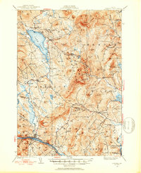
(36)- 1924 Map of Farmington
 1924 Farmington1924 Print · USGSFranklin County in the early 1920s is a landscape of river-powered mills and intersecting rail lines, including the Sandy River and Rangeley Lakes RR. Genealogists can locate dozens of country schools and rural settlements like Allens Mills and Knowltons Corner.6 unique versions available
 - 1926 Map of Dixfield, 1953 Print
 1926 Dixfield1953 Print · USGSWestern Maine's river valleys and highlands are captured here in the mid-twenties, showcasing the region's rail and timber economy. Genealogists can trace family schoolhouses like Maple Grove Sch or locate old mill sites such as Hildreths Mill near Lake Webb.2 unique versions available
 - 1929 Map of Dixfield
 1929 Dixfield1929 Print · USGSFranklin and Oxford Counties are captured here in the late twenties, showing the transition from mountain peaks to river valley commerce. Genealogists and historians can trace district schools and old farmstead locations from Weld Corner Sch. down to the Maine Central rail lines at Dixfield.5 unique versions available
 - 1950 Map of Lewiston
 1950 Lewiston1950 Print · USGSThe Maine and New Hampshire borderlands come alive in this post-war survey of the White Mountains and Androscoggin valley. Genealogists and historians can trace rail lines like the Maine Central Railroad and find high-altitude landmarks from Mount Washington to Bretton Woods.2 unique versions available
 - 1956 Map of Dixfield, 1958 Print
 1956 Dixfield1958 Print · USGSIn the mid-1950s, the western Maine landscape centered on the bustling river town of Dixfield and the expanses of Mt Blue State Park. Genealogists and historians can trace family cemeteries like Birchland Cem and old industrial sites like Hildreths Mill.5 unique versions available
 - 1956 Map of Farmington, 1959 Print
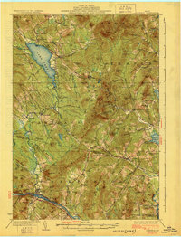
 1956 Farmington1959 Print · USGSMid-century Franklin County, Maine, reveals a landscape of river-driven industry and upland farming. Researchers can trace the rail connections through Wilton Station or locate family roots near Knowltons Corner, Intervale School, and Savage Cemetery.3 unique versions available
 - 1956 Map of Lewiston, 1975 Print
 1956 Lewiston1975 Print · USGSThe Northern New England interior is documented here in the mid-fifties, from the industrial Androscoggin River to the high peaks of the White Mountains. Trace the Grand Trunk Railway through mountain passes or locate family landmarks near Sabbathday Lake and Bretton Woods.
 - 1961 Map of Lewiston
 1961 Lewiston1961 Print · USGSWestern Maine and the White Mountains appear here during the early sixties, showing the industrial river towns and vast timberlands before the modern interstate era. Genealogists and historians can trace the Grand Trunk RR through Berlin or locate landmarks like Old Speck Mountain and Elephant Mountain.
 - 1962 Map of Lewiston
 1962 Lewiston1962 Print · USGSThe industrial river valleys and high peaks of Maine and New Hampshire define the region in the early sixties. Trace the rail-and-river network from Lewiston to the White Mountains, passing through mill towns like Berlin and Rumford.
 - 1968 Map of Mount Blue, 1970 Print
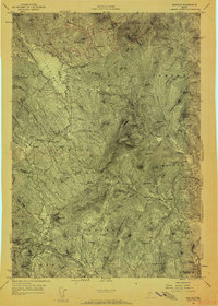
 1968 Mount Blue1970 Print · USGSFranklin County's high country and wooded plantations are captured here in the late sixties, showcasing the high-elevation terrain of Mount Blue State Park. Genealogists and local historians can trace family-named sites like Hildreths Mill, Staples Cem, and the small settlement at Temple Intervale.2 unique versions available
 - 1968 Map of East Dixfield, 1970 Print
 1968 East Dixfield1970 Print · USGSWestern Maine highlands meet the river valleys in the late sixties, showcasing the rural landscapes of Franklin and Oxford Counties. Genealogists can locate family landmarks like Science Hill Cemetery, Walker Hill, and the community of East Dixfield.2 unique versions available
 - 1968 Map of Wilton, 1971 Print
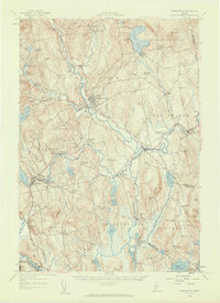
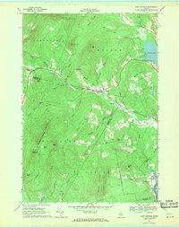
 1968 Wilton1971 Print · USGSFranklin County's transition from rural crossroads to an industrial corridor is captured here in the late sixties. Researchers can trace family sites near Lakeview Cem or locate historic industrial sites such as the quarries near North Jay and the Central Maine Railroad.
 - 1968 Map of Farmington, 1971 Print
 1968 Farmington1971 Print · USGSFarmington and the Sandy River valley are captured here in the late sixties, showing the town's expansion and educational institutions. Genealogists can locate numerous burial sites like Riverside Cem and Red Schoolhouse Cem, or trace the grounds of Farmington State College.
 - 1969 Map of Lewiston
 1969 Lewiston1969 Print · USGSThe northern New England highlands come into focus during the mid-fifties, showing the vital rail and river networks connecting industrial centers to the deep woods. Researchers can trace the path of the Grand Trunk RR or locate landmarks like Mt Washington and Rangeley Lake.
 - 1986 Map of Rumford
 1986 Rumford1986 Print · USGSWestern Maine in the mid-eighties shows a rugged landscape of industrial river towns and high-country timber plantations. Trace the rail-and-river economy through Rumford, Dixfield, and the Maine Central RR or locate the historic campus of Farmington State College.
 - 1994 Map of Rumford
 1994 Rumford1994 Print · USGSWestern Maine's mountains and glacial lakes are shown here in the mid-1990s, from the peaks of the Mahoosuc Range to the banks of the Androscoggin River. Trace the Maine Central RR through Dixfield or locate lakeside settlements like Oquossoc.
 - 2011 Map of Farmington, 2011 Print
 2011 Farmington2011 Print · USGSCovers Wilton, including Farmington, Strong, and other nearby areas
 - 2011 Map of Mount Blue, 2011 Print
 2011 Mount Blue2011 Print · USGSCovers Wilton, including Temple, Carthage, and other nearby areas
 - 2011 Map of Wilton, 2011 Print
 2011 Wilton2011 Print · USGSCovers Wilton, including Farmington, Jay, and other nearby areas
 - 2011 Map of East Dixfield, 2011 Print
 2011 East Dixfield2011 Print · USGSCovers Wilton, including Jay, Dixfield, and other nearby areas
 - 2014 Map of Mount Blue, 2014 Print
 2014 Mount Blue2014 Print · USGSCovers Wilton, including Temple, Carthage, and other nearby areas
 - 2014 Map of Wilton, 2014 Print
 2014 Wilton2014 Print · USGSCovers Wilton, including Farmington, Jay, and other nearby areas
 - 2014 Map of East Dixfield, 2014 Print
 2014 East Dixfield2014 Print · USGSCovers Wilton, including Jay, Dixfield, and other nearby areas
 - 2014 Map of Farmington, 2014 Print
 2014 Farmington2014 Print · USGSCovers Wilton, including Farmington, Strong, and other nearby areas
 - 2018 Map of East Dixfield, 2018 Print
 2018 East Dixfield2018 Print · USGSCovers Wilton, including Jay, Dixfield, and other nearby areas
Showing maps 1-25 of 36
Top cities near Wilton
- Farmington historical maps
- Jay historical maps
- Livermore Falls historical maps
- Mexico historical maps
- Readfield historical maps
- Anson historical maps
See more
Top neighborhoods of Wilton
- Dryden historical maps
- East Dixfield historical maps
- East Wilton historical maps
- Wilton Intervale historical maps
- MacQuillis Corner historical maps
Frequently asked questions
- What are the different types of historical maps available for Wilton?
- What is the oldest map of Wilton?
- Where can I purchase historical maps of Wilton for my home or office?
- Where can I download high-res historical maps of Wilton?
- Are there historical topographic maps available for Wilton?
- Is there historical aerial imagery available for Wilton?
- Where are historical maps of Wilton sourced from?