1980s Maps of Franklin, Maine
Explore 5 historic maps of Franklin from the 1980s. These maps offer a rare glimpse into what life looked like during the 1980s — showing old roads, neighborhoods, homes, and landmarks that have changed or disappeared over time.
Whether you're researching your family's past, planning a metal detecting trip, or studying how Franklin's landscape evolved across the 1980s, these high-resolution maps are a powerful tool for exploring the history of this region.
- Focus on a specific era: All maps on this page are from the 1980s, giving you a focused view of this time period.
- See what’s changed: Compare century-old streets, trails, and buildings to today's modern landscape using overlays and satellite layers.
- Research with precision: Use these maps for genealogy, historical research, land use analysis, or educational projects.
- View, download, or print: Maps are fully viewable online in high resolution, and can be downloaded or printed for your own records.
Start exploring Franklin's history through authentic maps from the 1980s. This is your window into the past.
Franklin, ME maps
(5)- 1981 Map of Eastbrook, 1982 Print
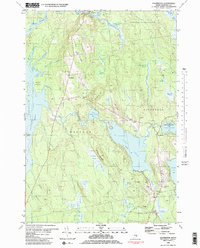 1981 Eastbrook1982 Print · USGSHancock County’s inland ridges and heaths are meticulously documented in this late-twentieth-century study of the Eastbrook and Waltham vicinity. Researchers can locate family burial sites at Sunnyside Cem, the old Cave Hill Sch, and landmarks along Waltham Ridge.2 unique versions available
 - 1981 Map of Hancock, 1982 Print
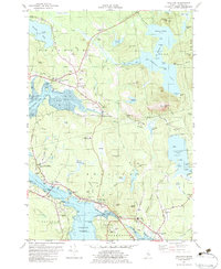
 1981 Hancock1982 Print · USGSCoastal Hancock County and the Taunton Bay shoreline appear in detail during the early eighties as the local economy balanced rail transport and maritime life. Genealogists and researchers can trace family landmarks like Abbott Cem, the Hancock Sch, and the winding path of the Maine Central Railroad.
 - 1982 Map of Molasses Pond, 1983 Print
 1982 Molasses Pond1983 Print · USGSHancock County’s intricate interior wetlands and ridges are captured here during the early eighties. Researchers can trace land use through the Lyle Frost Wildlife Management Area and locate family landmarks like Crimmins Cem or Macomber Mill Str.
 - 1982 Map of Sullivan, 1983 Print
 1982 Sullivan1983 Print · USGSCoastal Hancock County in the early eighties shows a landscape shaped by tidal bays and the MAINE CENTRAL RAILROAD. Genealogists and historians can trace local family roots through sites like York Hill Cemetery, Sullivan Harbor Church, and the many Quarries near North Sullivan.2 unique versions available
 - 1985 Map of Bangor
 1985 Bangor1985 Print · USGSMid-Maine during the mid-eighties centers on the industrial pulse of the Penobscot River and its critical rail connections. Genealogists and historians can trace the development of river towns from Old Town to Ellsworth and locate regional landmarks like Fort Knox State Park.
End of results
Showing maps 1-5 of 5
Top cities near Franklin
- Ellsworth historical maps
- Bar Harbor historical maps
- Hancock historical maps
- Mount Desert historical maps
- Lamoine historical maps
- Gouldsboro historical maps
See more
Top neighborhoods of Franklin
Frequently asked questions
- What are the different types of historical maps available for Franklin?
- What is the oldest map of Franklin?
- Where can I purchase historical maps of Franklin for my home or office?
- Where can I download high-res historical maps of Franklin?
- Are there historical topographic maps available for Franklin?
- Is there historical aerial imagery available for Franklin?
- Where are historical maps of Franklin sourced from?