1980s Maps of Mariaville, Maine
Explore 6 historic maps of Mariaville from the 1980s. These maps offer a rare glimpse into what life looked like during the 1980s — showing old roads, neighborhoods, homes, and landmarks that have changed or disappeared over time.
Whether you're researching your family's past, planning a metal detecting trip, or studying how Mariaville's landscape evolved across the 1980s, these high-resolution maps are a powerful tool for exploring the history of this region.
- Focus on a specific era: All maps on this page are from the 1980s, giving you a focused view of this time period.
- See what’s changed: Compare century-old streets, trails, and buildings to today's modern landscape using overlays and satellite layers.
- Research with precision: Use these maps for genealogy, historical research, land use analysis, or educational projects.
- View, download, or print: Maps are fully viewable online in high resolution, and can be downloaded or printed for your own records.
Start exploring Mariaville's history through authentic maps from the 1980s. This is your window into the past.
Mariaville, ME maps
(6)- 1981 Map of Ellsworth, 1982 Print
 1981 Ellsworth1982 Print · USGSThe riverfront and rail lines of this Hancock County hub were well-established by the early eighties. Genealogists and local historians can trace the foundations of Ellsworth through its community landmarks, from the Juniper Cem to the Maine Central RR tracks.
 - 1981 Map of Eastbrook, 1982 Print
 1981 Eastbrook1982 Print · USGSHancock County’s inland ridges and heaths are meticulously documented in this late-twentieth-century study of the Eastbrook and Waltham vicinity. Researchers can locate family burial sites at Sunnyside Cem, the old Cave Hill Sch, and landmarks along Waltham Ridge.2 unique versions available
 - 1981 Map of Beech Hill Pond, 1982 Print
 1981 Beech Hill Pond1982 Print · USGSCoastal Maine's interior lake country comes into focus in the early eighties as local roads began to trace the shorelines of Beech Hill Pond and Green Lake. Genealogists can locate family sites like Pyles Cem or the Beech Hill Sch while tracing the East Br Union R through the woods.2 unique versions available
 - 1985 Map of Bangor
 1985 Bangor1985 Print · USGSMid-Maine during the mid-eighties centers on the industrial pulse of the Penobscot River and its critical rail connections. Genealogists and historians can trace the development of river towns from Old Town to Ellsworth and locate regional landmarks like Fort Knox State Park.
 - 1988 Map of Hopkins Pond
 1988 Hopkins Pond1988 Print · USGSHancock County was a landscape of remote ponds and granite peaks in the late eighties, just as many of its rural areas were being formally mapped. Researchers can trace land tracts near Archers Corners and Goodwin, or locate family landmarks like Chick Hill and Hopkins Pond.
 - 1988 Map of Amherst
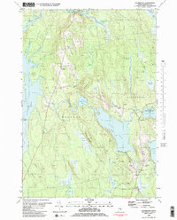
 1988 Amherst1988 Print · USGSHancock County’s river-carved interior is documented here in the late eighties, featuring the convergence of the Union River branches. Researchers can trace the unique glacial geology of The Whalesback and the small rural crossroads of Amherst, Aurora, and North Mariaville.
End of results
Showing maps 1-6 of 6
Top cities near Mariaville
- Ellsworth historical maps
- Holden historical maps
- Milford historical maps
- Blue Hill historical maps
- Hancock historical maps
- Orland historical maps
See more
Top neighborhoods of Mariaville
Frequently asked questions
- What are the different types of historical maps available for Mariaville?
- What is the oldest map of Mariaville?
- Where can I purchase historical maps of Mariaville for my home or office?
- Where can I download high-res historical maps of Mariaville?
- Are there historical topographic maps available for Mariaville?
- Is there historical aerial imagery available for Mariaville?
- Where are historical maps of Mariaville sourced from?