1970s Maps of Litchfield, Maine
Explore 2 historic maps of Litchfield from the 1970s. These maps offer a rare glimpse into what life looked like during the 1970s — showing old roads, neighborhoods, homes, and landmarks that have changed or disappeared over time.
Whether you're researching your family's past, planning a metal detecting trip, or studying how Litchfield's landscape evolved across the 1970s, these high-resolution maps are a powerful tool for exploring the history of this region.
- Focus on a specific era: All maps on this page are from the 1970s, giving you a focused view of this time period.
- See what’s changed: Compare century-old streets, trails, and buildings to today's modern landscape using overlays and satellite layers.
- Research with precision: Use these maps for genealogy, historical research, land use analysis, or educational projects.
- View, download, or print: Maps are fully viewable online in high resolution, and can be downloaded or printed for your own records.
Start exploring Litchfield's history through authentic maps from the 1970s. This is your window into the past.
Litchfield, ME maps
(2)- 1979 Map of Monmouth
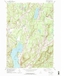 1979 Monmouth1979 Print · USGSAndroscoggin and Kennebec Counties are shown in the late seventies as a landscape of interconnected ponds, ridges, and small rail-side hamlets. Genealogists can locate family sites near Leeds Plain Cem, the old Sprague Mill, or the community hub at Wales Corner.
 - 1979 Map of Lisbon Falls North
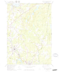 1979 Lisbon Falls North1979 Print · USGSLisbon and Sabattus appear at a crossroads of industry and tradition in the late seventies as the river-driven economy continued to shape the county. Researchers can trace family roots through numerous small burial grounds like Furbush Cem and Spear Cem or locate the old Webster School.3 unique versions available
End of results
Showing maps 1-2 of 2
Top cities near Litchfield
- Lewiston historical maps
- Brunswick historical maps
- Augusta historical maps
- Lisbon historical maps
- Topsham historical maps
- Bath historical maps
See more
Top neighborhoods of Litchfield
- Batchelders Crossing historical maps
- Litchfield Plains historical maps
- Purgatory historical maps
- Ring Hill historical maps
- Litchfield Corners historical maps
Frequently asked questions
- What are the different types of historical maps available for Litchfield?
- What is the oldest map of Litchfield?
- Where can I purchase historical maps of Litchfield for my home or office?
- Where can I download high-res historical maps of Litchfield?
- Are there historical topographic maps available for Litchfield?
- Is there historical aerial imagery available for Litchfield?
- Where are historical maps of Litchfield sourced from?