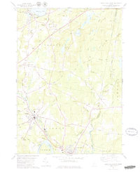
1979 Map of Lisbon Falls North
USGS Topo · Published 1979About this map
Lisbon and its surrounding mill towns are defined by the powerful flow of the Androscoggin River and the Sabattus River during the late 1970s. The landscape is a network of rural hubs including Lisbon Center, Lisbon Falls, and Sabattus, connected by the historical Maine Central railroad line and various gravel operations. The density of family-named landmarks like Drinkwater Corner and Robinson Corner suggests a long-standing community structure where local identity was tied to specific intersections and homesteads.
Find a feature on this map
71 named features on this map. Tap any name to fly to it.
Don’t see what you’re looking for? This feature index may not catch every label — zoom into the map to look around manually.
Map Details
Editions of this 1979 Lisbon Falls North Map
3 editions found
Other maps of this area

1892 · Gardiner
USGS Topo · 1:62,500

1892 · Freeport
USGS Topo · 1:62,500

1894 · Bath
USGS Topo · 1:62,500

1908 · Lewiston
USGS Topo · 1:62,500

1920 · Bath
USGS Topo · 1:62,500

1941 · Freeport
USGS Topo · 1:62,500

1942 · Lewiston
USGS Topo · 1:62,500

1943 · Gardiner
USGS Topo · 1:62,500

1944 · Freeport
USGS Topo · 1:62,500

1945 · Bath
USGS Topo · 1:62,500