Old Maps of Bethel, Maine for Academic Research
Study the evolution of Bethel with 40 high-resolution historic maps. Whether you're teaching, researching, or modeling changes in land use, these maps provide essential visual documentation of urban, environmental, and geographic change.
- Analyze long-term change: Track patterns in development, transportation, and natural features.
- Ideal for environmental or urban studies: Support academic projects with primary historical map data.
- Use in the classroom or lab: Educators and researchers rely on these maps to bring historical context to life.
These maps are a powerful tool for teaching, research, and visualizing how Bethel has changed over the decades.
Bethel, ME maps
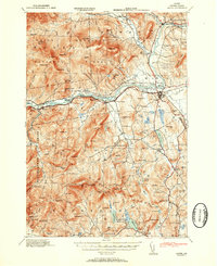
(40)- 1911 Map of Bryant Pond, 1953 Print
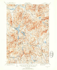 1911 Bryant Pond1953 Print · USGSOxford County at the start of the twentieth century shows a landscape of mountain ridges and valley mill towns. You can trace the rural school system and early transport lines through Bryant Pond, West Paris, and the waters of Mt Zircon Spring.3 unique versions available
 - 1914 Map of Bethel
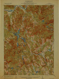
 1914 Bethel1914 Print · USGSOxford County mountain life and river valley commerce converge in this pre-World War I survey of the Bethel region. Genealogists and historians can trace old homestead paths to the Town House, several rural schoolhouses like Dresser School, and the path of the Grand Trunk R R.5 unique versions available
 - 1914 Map of Bryant Pond
 1914 Bryant Pond1914 Print · USGSOxford County at the dawn of the Great War was a land of valley mills and mountain schools connected by the iron rail. Genealogists can trace family footprints near Paris Hill, or locate long-standing landmarks like Abbotts Mill and the Patch Mountain School.4 unique versions available
 - 1940 Map of Bethel, 1958 Print
 1940 Bethel1958 Print · USGSOxford County at the dawn of the 1940s reveals a landscape of river-valley farming and mountain timberlands. Genealogists and local historians can locate early district schools like Sunday River Sch, the Town House in Albany, and mountain notches like Tyler Notch.2 unique versions available
 - 1941 Map of Bethel
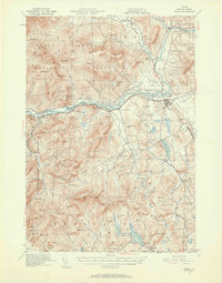
 1941 Bethel1941 Print · USGSOxford County was a landscape of mountain ridges and narrow river valleys just before the mid-century, centered on the Androscoggin River. Genealogists can trace family names and rural landmarks like the Bethel Cem, Mason School, and the village at Town House.
 - 1942 Map of Bryant Pond
 1942 Bryant Pond1942 Print · USGSOxford County at the dawn of the 1940s shows a landscape of mountain ridges and busy valley railroads. Genealogists can locate family-named landmarks like Walkers Mill and Trap Corner or trace rural education at the Millettville Sch and Patch Mountain Sch.
 - 1950 Map of Lewiston
 1950 Lewiston1950 Print · USGSThe Maine and New Hampshire borderlands come alive in this post-war survey of the White Mountains and Androscoggin valley. Genealogists and historians can trace rail lines like the Maine Central Railroad and find high-altitude landmarks from Mount Washington to Bretton Woods.2 unique versions available
 - 1953 Map of Bethel
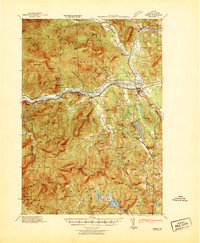
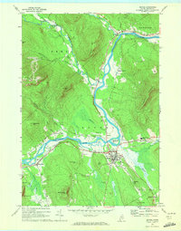
 1953 Bethel1953 Print · USGSThe Androscoggin River valley is captured here in the early 1950s, showing the agricultural and mountain landscape of Oxford County. Local historians can trace old community hubs like Bethel, Gilead, and Hanover, along with numerous rural schoolhouses such as Chapman Sch and Peabody Sch.2 unique versions available
 - 1956 Map of Lewiston, 1975 Print
 1956 Lewiston1975 Print · USGSThe Northern New England interior is documented here in the mid-fifties, from the industrial Androscoggin River to the high peaks of the White Mountains. Trace the Grand Trunk Railway through mountain passes or locate family landmarks near Sabbathday Lake and Bretton Woods.
 - 1961 Map of Lewiston
 1961 Lewiston1961 Print · USGSWestern Maine and the White Mountains appear here during the early sixties, showing the industrial river towns and vast timberlands before the modern interstate era. Genealogists and historians can trace the Grand Trunk RR through Berlin or locate landmarks like Old Speck Mountain and Elephant Mountain.
 - 1962 Map of Lewiston
 1962 Lewiston1962 Print · USGSThe industrial river valleys and high peaks of Maine and New Hampshire define the region in the early sixties. Trace the rail-and-river network from Lewiston to the White Mountains, passing through mill towns like Berlin and Rumford.
 - 1967 Map of Bryant Pond, 1969 Print
 1967 Bryant Pond1969 Print · USGSThe Oxford County highlands in the late sixties show a landscape shaped by the Grand Trunk rail corridor and the Androscoggin River. Genealogists can locate family names at Bartlett Cem or Howe Hill Cem and trace the mills at Locke Mills.3 unique versions available
 - 1969 Map of Lewiston
 1969 Lewiston1969 Print · USGSThe northern New England highlands come into focus during the mid-fifties, showing the vital rail and river networks connecting industrial centers to the deep woods. Researchers can trace the path of the Grand Trunk RR or locate landmarks like Mt Washington and Rangeley Lake.
 - 1970 Map of Gilead, 1972 Print
 1970 Gilead1972 Print · USGSThe confluence of the Androscoggin River and Wild River defines this Oxford County landscape in the early seventies. Genealogists and hikers can trace the Trunk Road past Gilead, find the Chapman Cem, or locate the Mine near the Bethel border.
 - 1970 Map of East Stoneham, 1972 Print
 1970 East Stoneham1972 Print · USGSOxford County in the early seventies shows a landscape of dense national forest and scattered mountain settlements. Genealogists and hikers can trace old family burial sites like Songo Cem or navigate the terrain near Albany Notch and East Stoneham.2 unique versions available
 - 1970 Map of Bethel, 1972 Print
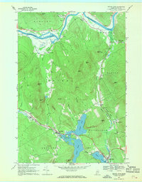
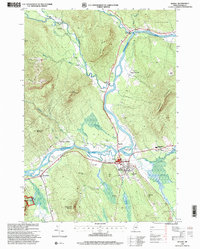
 1970 Bethel1972 Print · USGSBethel and the surrounding Oxford County highlands are captured here during the 1970s as the rail and river economy shaped the valley. Genealogists and historians can trace family plots at Skillingston Cem, locate the historic Gould Academy, or follow the path of the Grand Trunk railroad through West Bethel.2 unique versions available
 - 1986 Map of Lewiston
 1986 Lewiston1986 Print · USGSMaine’s industrial river valleys and western mountain foothills are captured here in the mid-eighties as rail and road networks tied the region together. Genealogists and historians can trace the development of mill towns and lakefront settlements from Lisbon to Bethel, following the Androscoggin River and the path of the Maine Central Railroad.2 unique versions available
 - 1995 Map of Gilead, 2000 Print
 1995 Gilead2000 Print · USGSOxford County in the mid-nineties shows the town of Gilead nestled along the Androscoggin River as it winds through mountain gaps. Genealogists and hikers can trace family names at Chapman Cemetery, locate the old Gaging Station, and scout the steep slopes of Tumbledown Dick Mountain.
 - 1995 Map of Bethel, 2000 Print
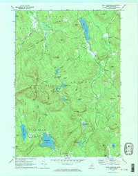
 1995 Bethel2000 Print · USGSThe Oxford Hills come into focus in the mid-nineties as the Androscoggin River valley balances its agricultural roots with a growing recreation economy. Genealogists and local historians can trace family sites at Sunday River Cemetery or locate landmarks like Gould Academy and the historic Covered Bridge.
 - 1995 Map of East Stoneham, 2000 Print
 1995 East Stoneham2000 Print · USGSThe foothills of the Oxford County mountains come alive in the mid-nineties, showing a landscape defined by timber, tourism, and deep-rooted settlements. Trace the local geography from East Stoneham north through White Mountain National Forest to find Flat Cemetery, Songo Pond, and Town House.
 - 2011 Map of Bryant Pond, 2011 Print
 2011 Bryant Pond2011 Print · USGSCovers Bethel, including Rumford, Woodstock, and other nearby areas
 - 2012 Map of Gilead, 2012 Print
 2012 Gilead2012 Print · USGSCovers Bethel, including Newry, Gilead, and other nearby areas
 - 2012 Map of East Stoneham, 2012 Print
 2012 East Stoneham2012 Print · USGSCovers Bethel, including Waterford, Lovell, and other nearby areas
 - 2012 Map of Bethel, 2012 Print
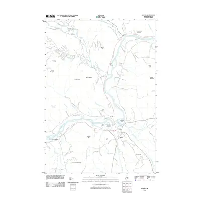 2012 Bethel2012 Print · USGSCovers Bethel, including Greenwood, Newry, and other nearby areas
 - 2014 Map of Bryant Pond, 2014 Print
 2014 Bryant Pond2014 Print · USGSCovers Bethel, including Rumford, Woodstock, and other nearby areas
Showing maps 1-25 of 40
Top cities near Bethel
- Paris historical maps
- Norway historical maps
- Rumford historical maps
- Oxford historical maps
- Mexico historical maps
- West Paris historical maps
See more
Top neighborhoods of Bethel
- West Bethel historical maps
- North Bethel historical maps
- East Bethel historical maps
- Mayville historical maps
- Middle Intervale historical maps
- Northwest Bethel historical maps
Frequently asked questions
- What are the different types of historical maps available for Bethel?
- What is the oldest map of Bethel?
- Where can I purchase historical maps of Bethel for my home or office?
- Where can I download high-res historical maps of Bethel?
- Are there historical topographic maps available for Bethel?
- Is there historical aerial imagery available for Bethel?
- Where are historical maps of Bethel sourced from?