1990s Maps of Gilead, Maine
Explore 5 historic maps of Gilead from the 1990s. These maps offer a rare glimpse into what life looked like during the 1990s — showing old roads, neighborhoods, homes, and landmarks that have changed or disappeared over time.
Whether you're researching your family's past, planning a metal detecting trip, or studying how Gilead's landscape evolved across the 1990s, these high-resolution maps are a powerful tool for exploring the history of this region.
- Focus on a specific era: All maps on this page are from the 1990s, giving you a focused view of this time period.
- See what’s changed: Compare century-old streets, trails, and buildings to today's modern landscape using overlays and satellite layers.
- Research with precision: Use these maps for genealogy, historical research, land use analysis, or educational projects.
- View, download, or print: Maps are fully viewable online in high resolution, and can be downloaded or printed for your own records.
Start exploring Gilead's history through authentic maps from the 1990s. This is your window into the past.
Gilead, ME maps
(5)- 1995 Map of Speckled Mountain, 2000 Print
 1995 Speckled Mountain2000 Print · USGSOxford County, Maine, is shown in the mid-1990s as a landscape of protected wilderness and mountain trails within the White Mountain National Forest. Researchers can trace the settlement at Hastings, locate a local Cemetery, and follow the Highwater Trail past Kees Falls.
 - 1995 Map of Wild River, 2000 Print
 1995 Wild River2000 Print · USGSThe White Mountains come alive in the 1990s as this map traces the intricate trail networks and wilderness reaches across the New Hampshire and Maine state line. Researchers can locate remote landmarks like the Brickett Place or trace the Appalachian Trail as it passes Middle Moriah Mountain.
 - 1995 Map of Gilead, 2000 Print
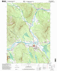
 1995 Gilead2000 Print · USGSOxford County in the mid-nineties shows the town of Gilead nestled along the Androscoggin River as it winds through mountain gaps. Genealogists and hikers can trace family names at Chapman Cemetery, locate the old Gaging Station, and scout the steep slopes of Tumbledown Dick Mountain.
 - 1995 Map of Bethel, 2000 Print
 1995 Bethel2000 Print · USGSThe Oxford Hills come into focus in the mid-nineties as the Androscoggin River valley balances its agricultural roots with a growing recreation economy. Genealogists and local historians can trace family sites at Sunday River Cemetery or locate landmarks like Gould Academy and the historic Covered Bridge.
 - 1995 Map of Shelburne, 2001 Print
 1995 Shelburne2001 Print · USGSThe northern New Hampshire border and the Wild River territory come alive in the mid-1990s as the Androscoggin River valley meets the high peaks. Hikers and historians can trace the Appalachian Scenic Trail past Gentian Pond and locate the historic Hazelton Cem near Shelburne.
End of results
Showing maps 1-5 of 5
Top cities near Gilead
- Berlin historical maps
- Rumford historical maps
- Gorham historical maps
- Bethel historical maps
- Waterford historical maps
- Milan historical maps
See more
Frequently asked questions
- What are the different types of historical maps available for Gilead?
- What is the oldest map of Gilead?
- Where can I purchase historical maps of Gilead for my home or office?
- Where can I download high-res historical maps of Gilead?
- Are there historical topographic maps available for Gilead?
- Is there historical aerial imagery available for Gilead?
- Where are historical maps of Gilead sourced from?