1970s Maps of Gilead, Maine
Explore 5 historic maps of Gilead from the 1970s. These maps offer a rare glimpse into what life looked like during the 1970s — showing old roads, neighborhoods, homes, and landmarks that have changed or disappeared over time.
Whether you're researching your family's past, planning a metal detecting trip, or studying how Gilead's landscape evolved across the 1970s, these high-resolution maps are a powerful tool for exploring the history of this region.
- Focus on a specific era: All maps on this page are from the 1970s, giving you a focused view of this time period.
- See what’s changed: Compare century-old streets, trails, and buildings to today's modern landscape using overlays and satellite layers.
- Research with precision: Use these maps for genealogy, historical research, land use analysis, or educational projects.
- View, download, or print: Maps are fully viewable online in high resolution, and can be downloaded or printed for your own records.
Start exploring Gilead's history through authentic maps from the 1970s. This is your window into the past.
Gilead, ME maps
(5)- 1970 Map of Gilead, 1972 Print
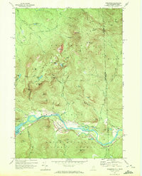
 1970 Gilead1972 Print · USGSThe confluence of the Androscoggin River and Wild River defines this Oxford County landscape in the early seventies. Genealogists and hikers can trace the Trunk Road past Gilead, find the Chapman Cem, or locate the Mine near the Bethel border.
 - 1970 Map of Speckled Mountain, 1972 Print
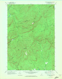 1970 Speckled Mountain1972 Print · USGSThe Maine backcountry in the early seventies reveals a landscape transition from timber extraction to forest recreation. Researchers can trace the layout of the Speckled Mtn Lookout Tower, the Hastings settlement, and several scenic Cold River Overlook sites.4 unique versions available
 - 1970 Map of Wild River, 1972 Print
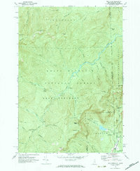 1970 Wild River1972 Print · USGSThe New Hampshire and Maine borderlands are shown here in the early 1970s, focused on the drainage of the Wild River. Trace the high-country Appalachian Trail and find backcountry landmarks like the Spruce Brook Shelter and Brickett Place.3 unique versions available
 - 1970 Map of Bethel, 1972 Print
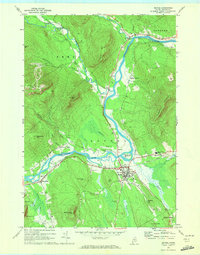 1970 Bethel1972 Print · USGSBethel and the surrounding Oxford County highlands are captured here during the 1970s as the rail and river economy shaped the valley. Genealogists and historians can trace family plots at Skillingston Cem, locate the historic Gould Academy, or follow the path of the Grand Trunk railroad through West Bethel.2 unique versions available
 - 1970 Map of Shelburne, 1972 Print
 1970 Shelburne1972 Print · USGSShelburne and the high Mahoosuc Range are documented in the early 1970s as the river valley served as a vital corridor for rail and energy transit. Trace the historic Appalachian Trail route past Gentian Pond or locate the Hazelton Cem and the Grand Trunk Railway line.3 unique versions available
End of results
Showing maps 1-5 of 5
Top cities near Gilead
- Berlin historical maps
- Rumford historical maps
- Gorham historical maps
- Bethel historical maps
- Waterford historical maps
- Milan historical maps
See more
Frequently asked questions
- What are the different types of historical maps available for Gilead?
- What is the oldest map of Gilead?
- Where can I purchase historical maps of Gilead for my home or office?
- Where can I download high-res historical maps of Gilead?
- Are there historical topographic maps available for Gilead?
- Is there historical aerial imagery available for Gilead?
- Where are historical maps of Gilead sourced from?