Old Maps of Center Lovell, Lovell for Hiking & Exploration
Hike through history with 12 historic maps of Center Lovell. Explore old trails, ghost towns, and forgotten backroads — perfect for outdoor adventurers and local explorers.
- Rediscover forgotten places: Map out old mining camps, roads, and footpaths that no longer exist on modern maps.
- Layer with modern tools: Combine with LiDAR or satellite views to plan hikes through historical terrain.
- Made for exploration: Popular among hikers, overlanders, and local history lovers.
Use these maps to find adventure and explore the hidden past of Center Lovell.
Center Lovell, Lovell maps
(12)- 1909 Map of Fryeburg, 1960 Print
 1909 Fryeburg1960 Print · USGSOxford County and the borderlands of Maine and New Hampshire were defined by the shifting waters of the Saco and the Kezar at the century's turn. Genealogists can trace family homesteads near the Battle Monument or locate rural schoolhouses like Foxboro School and Menotomy School.3 unique versions available
 - 1911 Map of Fryeburg
 1911 Fryeburg1911 Print · USGSOxford County at the start of the century shows a landscape of lake-fed valleys and the bustling rail corridor of the Maine Central RR. Genealogists and historians can trace old school districts like Foxboro School, local landmarks like the Battle Monument, and early settlements at Slab City and Lynchville.6 unique versions available
 - 1941 Map of Fryeburg
 1941 Fryeburg1941 Print · USGSOxford County and the Maine-New Hampshire borderlands are captured here just before the war, showcasing a landscape of isolated hills and interconnected lakes. Genealogists can locate family-named landmarks like Mc Daniels Hill and numerous rural schools including Plummer Sch and Black Mountain Sch.
 - 1950 Map of Lewiston
 1950 Lewiston1950 Print · USGSThe Maine and New Hampshire borderlands come alive in this post-war survey of the White Mountains and Androscoggin valley. Genealogists and historians can trace rail lines like the Maine Central Railroad and find high-altitude landmarks from Mount Washington to Bretton Woods.2 unique versions available
 - 1956 Map of Lewiston, 1975 Print
 1956 Lewiston1975 Print · USGSThe Northern New England interior is documented here in the mid-fifties, from the industrial Androscoggin River to the high peaks of the White Mountains. Trace the Grand Trunk Railway through mountain passes or locate family landmarks near Sabbathday Lake and Bretton Woods.
 - 1961 Map of Lewiston
 1961 Lewiston1961 Print · USGSWestern Maine and the White Mountains appear here during the early sixties, showing the industrial river towns and vast timberlands before the modern interstate era. Genealogists and historians can trace the Grand Trunk RR through Berlin or locate landmarks like Old Speck Mountain and Elephant Mountain.
 - 1962 Map of Lewiston
 1962 Lewiston1962 Print · USGSThe industrial river valleys and high peaks of Maine and New Hampshire define the region in the early sixties. Trace the rail-and-river network from Lewiston to the White Mountains, passing through mill towns like Berlin and Rumford.
 - 1963 Map of Center Lovell, 1965 Print
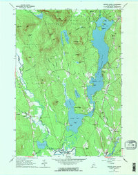 1963 Center Lovell1965 Print · USGSOxford County at the start of the 1960s shows a landscape of deep glacial lakes and forested peaks within the White Mountain National Forest. Researchers can locate historic family sites like the Smith Cem and Lord Cem, or trace the winding Old Course Saco River.2 unique versions available
 - 1969 Map of Lewiston
 1969 Lewiston1969 Print · USGSThe northern New England highlands come into focus during the mid-fifties, showing the vital rail and river networks connecting industrial centers to the deep woods. Researchers can trace the path of the Grand Trunk RR or locate landmarks like Mt Washington and Rangeley Lake.
 - 1986 Map of Lewiston
 1986 Lewiston1986 Print · USGSMaine’s industrial river valleys and western mountain foothills are captured here in the mid-eighties as rail and road networks tied the region together. Genealogists and historians can trace the development of mill towns and lakefront settlements from Lisbon to Bethel, following the Androscoggin River and the path of the Maine Central Railroad.2 unique versions available
 - 1995 Map of Center Lovell, 2000 Print
 1995 Center Lovell2000 Print · USGSThe Kezar Lake region of Oxford County appears in detail during the mid-nineties, showing the balance between the White Mountain wilderness and lakeside village life. Researchers can locate family landmarks like Smith Cem, Lord Cem, and the old Bemis Cem - Bradley Church.
 - 2024 Map of Center Lovell, 2024 Print
 2024 Center Lovell2024 Print · USGSOxford County's lake country is captured here in the 2020s, showing the established communities and shoreline developments around Kezar Lake. Researchers can locate numerous family burial grounds like Fox Cem and Bemis Cem, or trace the historical path of the Old Course Saco River.
End of results
Showing maps 1-12 of 12
Top cities near Center Lovell
- Bridgton historical maps
- Norway historical maps
- Naples historical maps
- Conway historical maps
- Fryeburg historical maps
- Bartlett historical maps
See more
Frequently asked questions
- What are the different types of historical maps available for Center Lovell?
- What is the oldest map of Center Lovell?
- Where can I purchase historical maps of Center Lovell for my home or office?
- Where can I download high-res historical maps of Center Lovell?
- Are there historical topographic maps available for Center Lovell?
- Is there historical aerial imagery available for Center Lovell?
- Where are historical maps of Center Lovell sourced from?