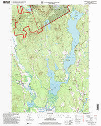
1995 Map of Center Lovell
USGS Topo · Published 2000About this map
Kezar Lake dominates the central landscape of this western Maine region, its waters divided into the Upper Bay, Middle Bay, and Lower Bay. Along the eastern shore, the village of Center Lovell and the smaller settlement of Number Four mark the primary areas of human activity, while the western portion is defined by the high peaks of the White Mountain National Forest, including Stiles Mountain and Deer Hill.
Find a feature on this map
87 named features on this map. Tap any name to fly to it.
Don’t see what you’re looking for? This feature index may not catch every label — zoom into the map to look around manually.
Map Details
Editions of this 1995 Center Lovell Map
This is the sole edition of this map. No revisions or reprints were ever made.
Other maps of this area

1893 · Gorham
USGS Topo · 1:62,500

1894 · North Conway
USGS Topo · 1:62,500

1896 · North Conway
USGS Topo · 1:62,500

1896 · Gorham
USGS Topo · 1:62,500

1909 · Fryeburg
USGS Topo · 1:62,500

1911 · Fryeburg
USGS Topo · 1:62,500

1914 · Bethel
USGS Topo · 1:62,500

1937 · Gorham
USGS Topo · 1:48,000

1940 · Bethel
USGS Topo · 1:62,500

1941 · Bethel
USGS Topo · 1:62,500