1970s Maps of Newry, Maine
Explore 4 historic maps of Newry from the 1970s. These maps offer a rare glimpse into what life looked like during the 1970s — showing old roads, neighborhoods, homes, and landmarks that have changed or disappeared over time.
Whether you're researching your family's past, planning a metal detecting trip, or studying how Newry's landscape evolved across the 1970s, these high-resolution maps are a powerful tool for exploring the history of this region.
- Focus on a specific era: All maps on this page are from the 1970s, giving you a focused view of this time period.
- See what’s changed: Compare century-old streets, trails, and buildings to today's modern landscape using overlays and satellite layers.
- Research with precision: Use these maps for genealogy, historical research, land use analysis, or educational projects.
- View, download, or print: Maps are fully viewable online in high resolution, and can be downloaded or printed for your own records.
Start exploring Newry's history through authentic maps from the 1970s. This is your window into the past.
Newry, ME maps
(4)- 1970 Map of Gilead, 1972 Print
 1970 Gilead1972 Print · USGSThe confluence of the Androscoggin River and Wild River defines this Oxford County landscape in the early seventies. Genealogists and hikers can trace the Trunk Road past Gilead, find the Chapman Cem, or locate the Mine near the Bethel border.
 - 1970 Map of Bethel, 1972 Print
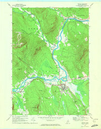 1970 Bethel1972 Print · USGSBethel and the surrounding Oxford County highlands are captured here during the 1970s as the rail and river economy shaped the valley. Genealogists and historians can trace family plots at Skillingston Cem, locate the historic Gould Academy, or follow the path of the Grand Trunk railroad through West Bethel.2 unique versions available
 - 1977 Map of Old Speck Mountain, 1983 Print
 1977 Old Speck Mountain1983 Print · USGSThe mountains of western Maine appear in sharp detail through 1970s aerial photography. Trace the rugged drainages of Swift Cambridge River and Bull Branch while studying the peaks of Old Speck Mountain.
 - 1977 Map of Puzzle Mountain, 1983 Print
 1977 Puzzle Mountain1983 Print · USGSNorth Newry and the high peaks of Oxford County appear in this detailed 1970s orthophotograph. Researchers can trace the narrow settlement patterns along the Bear River and the forested slopes of Puzzle Mountain and Long Mountain.
End of results
Showing maps 1-4 of 4
Top cities near Newry
- Norway historical maps
- Rumford historical maps
- Mexico historical maps
- Bethel historical maps
- West Paris historical maps
- Woodstock historical maps
See more
Top neighborhoods of Newry
Frequently asked questions
- What are the different types of historical maps available for Newry?
- What is the oldest map of Newry?
- Where can I purchase historical maps of Newry for my home or office?
- Where can I download high-res historical maps of Newry?
- Are there historical topographic maps available for Newry?
- Is there historical aerial imagery available for Newry?
- Where are historical maps of Newry sourced from?