Old Maps of Alton, Maine for Metal Detecting
Plan your next treasure hunt with 52 historic maps of Alton. Find old homesites, ghost towns, trails, and gathering spots that may be lost to time — perfect for identifying promising metal detecting locations.
- Locate forgotten sites: Uncover places like long-lost settlements, abandoned rail lines, or gathering spots.
- Plan better hunts: Use map overlays combined with LiDAR or satellite views to narrow in on historically rich areas.
- Made for detectorists: Thousands of hobbyists use these maps to discover relics, coins, and hidden history.
Use these historic maps to boost your research and find new opportunities beneath the surface of Alton.
Alton, ME maps
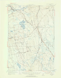
(52)- 1902 Map of Orono
 1902 Orono1902 Print · USGSPenobscot River life at the turn of the century centered on a busy corridor of rail, river, and industry. Researchers can trace the early footprint of the University, the rail lines of the Bangor and Aroostook RR, and settlements like Basin Mills and Indian Island.6 unique versions available
 - 1902 Map of Bangor
 1902 Bangor1902 Print · USGSThe Penobscot River valley at the turn of the century shows a bustling hub of rail and river commerce connecting Bangor and Brewer. Genealogists and historians can trace old homesteads and transit routes through Kenduskeag, Leather Corner, and along the Maine Central R. R.6 unique versions available
 - 1917 Map of Passadumkeag
 1917 Passadumkeag1917 Print · USGSIn the early twentieth century, the Penobscot River valley was a busy corridor of rail transit and small-town commerce. Genealogists can trace family footprints through numerous local schools like Hemlock School and the post office at West Enfield P.O.7 unique versions available
 - 1933 Map of Boyd Lake
 1933 Boyd Lake1933 Print · USGSPenobscot County communities and the Piscataquis River valley are captured here in the early thirties as the railroad remained the lifeblood of rural Maine. Local historians can trace numerous family-named landmarks and district schoolhouses like Knowles Sch, Ridge Sch, and the Huntington Mill works.
 - 1942 Map of Bangor
 1942 Bangor1942 Print · USGSThe Penobscot River valley thrives in this early-forties survey of the region's industrial and rural heart. Trace the historic street plans of Bangor and Brewer or locate family homesteads near Leather Corner and Snow Corner.
 - 1944 Map of Orono, 1954 Print
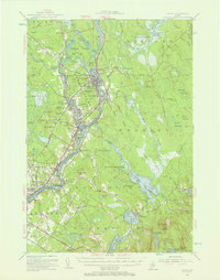
 1944 Orono1954 Print · USGSThe Penobscot River corridor is captured here in the mid-1940s, showing the early footprint of the University of Maine and the industrial activity of Old Town. Genealogists and historians can trace family locations through French Settlement, Woodlawn Cem, and the Old Gold Mine.2 unique versions available
 - 1946 Map of Bangor
 1946 Bangor1946 Print · USGSBangor and the Penobscot River are captured here in the mid-1940s, showing a critical hub of rail transport and military aviation. Local historians can trace the development of Dow Field, find local schools like Tennyson Sch, or locate family plots in Lakeview Cem.3 unique versions available
 - 1946 Map of Orono
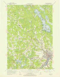
 1946 Orono1946 Print · USGSPenobscot County industry and academia meet along the river in the mid-forties. Genealogists and historians can trace the development of Marsh Island, locate the University of Maine campus, and find local landmarks like the Old Gold Mine Trail.2 unique versions available
 - 1948 Map of Bangor
 1948 Bangor1948 Print · USGSThe Maine coast and its industrial river valleys are captured here shortly after the war, showing the vital shipping and rail hubs of the late 1940s. Genealogists and historians can trace the tracks of the Maine Central RR connecting Bangor, Augusta, and Old Town.
 - 1951 Map of Boyd Lake
 1951 Boyd Lake1951 Print · USGSPenobscot and Piscataquis Counties are captured here in the early 1950s, showing a landscape of timber-rail economies and scattered rural schoolhouses. Genealogists can trace family footprints at Bradford Center, the Hoxie Sch, or along the Bangor and Aroostook rail line.
 - 1954 Map of Millinocket, 1968 Print
 1954 Millinocket1968 Print · USGSMaine's North Woods and the Penobscot Valley are captured here during the mid-century era of logging and rail dominance. You can trace the path of the Bangor and Aroostook Railroad through timber towns like Millinocket, Mattawamkeag, and Silver Ridge.3 unique versions available
 - 1955 Map of Boyd Lake, 1956 Print
 1955 Boyd Lake1956 Print · USGSPenobscot and Piscataquis counties are captured here in the mid-fifties as the rail-and-river economy supported towns like Milo and Derby. Genealogists can locate family landmarks such as the Orneville Sch, Williams Cem, and the Bradford High Sch.4 unique versions available
 - 1955 Map of Orono, 1957 Print
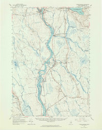
 1955 Orono1957 Print · USGSThe Penobscot river valley thrived as a center of education and industry in the mid-fifties, anchored by Indian Island and the university. Genealogists and historians can trace family-named sites from French Settlement to Clewleyville Corners and the Old Gold Mine.4 unique versions available
 - 1955 Map of Bangor, 1957 Print
 1955 Bangor1957 Print · USGSBangor and the surrounding Penobscot Valley are captured here in the mid-fifties, showing a landscape defined by riverside industry and lakefront life. Researchers can trace historic rail connections at Northern Maine Junction and locate family landmarks like Lakeside Ldg or Evergreen Cem.3 unique versions available
 - 1956 Map of Bangor, 1966 Print
 1956 Bangor1966 Print · USGSMid-century Maine comes alive in this survey of the rugged coast and river valleys during the 1950s. Genealogists and historians can trace the vital rail corridors of the Maine Central RR connecting timber towns like Old Town to the coast at Bar Harbor.3 unique versions available
 - 1958 Map of Millinocket
 1958 Millinocket1958 Print · USGSMaine's North Woods and the Penobscot river valley are captured here in the mid-1950s, showing a landscape of timber, rail, and wild waters. Researchers can trace the legacy of the Canadian Pacific railroad and find historic settlements like Millinocket, Sherman Station, and Mattawamkeag.
 - 1960 Map of Bangor
 1960 Bangor1960 Print · USGSCentral Maine in the sixties reveals a landscape of river-powered industry and sprawling coastal island chains. Researchers can trace the rail corridors of the Maine Central or locate mid-century aviation landmarks like Dow Air Force Base.
 - 1960 Map of Millinocket
 1960 Millinocket1960 Print · USGSThe Maine North Woods and Penobscot River valley are captured at mid-century during the height of the paper milling era. Researchers can trace the Appalachian Trail near Mount Katardin or locate family roots in towns like Dover-Foxcroft and Milo.3 unique versions available
 - 1960 Map of Passadumkeag, 1964 Print
 1960 Passadumkeag1964 Print · USGSPenobscot River life in the early sixties centers on riverside towns and rail hubs like Passadumkeag and Olamon. Genealogists can trace family names through rural landmarks like Cedarvale Cem, Edgecomb Sch, and the State Nursery.2 unique versions available
 - 1961 Map of Bangor
 1961 Bangor1961 Print · USGSMid-century Maine comes alive through its busy river ports and rocky archipelagoes during a period of steady maritime and rail commerce. Researchers can trace the path of the Maine Central railroad and locate coastal landmarks from Acadia National Park to Vinalhaven Island.
 - 1975 Map of South Lagrange, 1981 Print
 1975 South Lagrange1981 Print · USGSPenobscot County is captured through mid-1970s aerial photography, revealing a landscape of remote settlements and expansive peatlands. Researchers can trace the development of South Lagrange and Gerry alongside features like Sargent Bog and Pickerel Pond.
 - 1975 Map of Greenbush, 1981 Print
 1975 Greenbush1981 Print · USGSPenobscot County in the mid-1970s is shown here through detailed aerial photography, highlighting the river-centered life of the Maine woods. Researchers can trace land clearings and homesteads near Greenbush or follow the paths of Hemlock Stream and Birch Stream.
 - 1977 Map of Pushaw Lake
 1977 Pushaw Lake1977 Print · USGSPenobscot County life in the late seventies is centered on the expansive waters of Pushaw Lake and the rural crossroads of Glenburn Center. Genealogists and local historians can trace the Bangor and Aroostook rail line, locate Lakeview Cem, or explore the many landings like Elliot Landing.
 - 1983 Map of South Lagrange, 1984 Print
 1983 South Lagrange1984 Print · USGSPenobscot County in the early eighties shows a landscape of interior wetlands and rail history. Trace the Bangor and Aroostook Railroad Grade and find local landmarks like South Lagrange, Gerry, and Christian Spring.
 - 1985 Map of Bangor
 1985 Bangor1985 Print · USGSMid-Maine during the mid-eighties centers on the industrial pulse of the Penobscot River and its critical rail connections. Genealogists and historians can trace the development of river towns from Old Town to Ellsworth and locate regional landmarks like Fort Knox State Park.
Showing maps 1-25 of 52
Top cities near Alton
- Bangor historical maps
- Orono historical maps
- Brewer historical maps
- Old Town historical maps
- Hermon historical maps
- Glenburn historical maps
See more
Top neighborhoods of Alton
Frequently asked questions
- What are the different types of historical maps available for Alton?
- What is the oldest map of Alton?
- Where can I purchase historical maps of Alton for my home or office?
- Where can I download high-res historical maps of Alton?
- Are there historical topographic maps available for Alton?
- Is there historical aerial imagery available for Alton?
- Where are historical maps of Alton sourced from?