1980s Maps of Milford, Maine
Explore 8 historic maps of Milford from the 1980s. These maps offer a rare glimpse into what life looked like during the 1980s — showing old roads, neighborhoods, homes, and landmarks that have changed or disappeared over time.
Whether you're researching your family's past, planning a metal detecting trip, or studying how Milford's landscape evolved across the 1980s, these high-resolution maps are a powerful tool for exploring the history of this region.
- Focus on a specific era: All maps on this page are from the 1980s, giving you a focused view of this time period.
- See what’s changed: Compare century-old streets, trails, and buildings to today's modern landscape using overlays and satellite layers.
- Research with precision: Use these maps for genealogy, historical research, land use analysis, or educational projects.
- View, download, or print: Maps are fully viewable online in high resolution, and can be downloaded or printed for your own records.
Start exploring Milford's history through authentic maps from the 1980s. This is your window into the past.
Milford, ME maps
(8)- 1985 Map of Bangor
 1985 Bangor1985 Print · USGSMid-Maine during the mid-eighties centers on the industrial pulse of the Penobscot River and its critical rail connections. Genealogists and historians can trace the development of river towns from Old Town to Ellsworth and locate regional landmarks like Fort Knox State Park.
 - 1985 Map of Lincoln, 1994 Print
 1985 Lincoln1994 Print · USGSPenobscot County in the mid-eighties remains a landscape of river-based commerce and sprawling timberlands connected by rail. You can trace the historic paths of the Maine Central RR and Canadian Pacific RR or locate rural sites like Enfield Station and the Winn Cem.
 - 1986 Map of Lincoln
 1986 Lincoln1986 Print · USGSMid-century Maine settlement and industry converge along the Penobscot and Piscataquis rivers during the 1980s. Researchers can trace the rail networks of the Maine Central and Bangor and Aroostook through towns like Howland and Milo.
 - 1988 Map of Olamon
 1988 Olamon1988 Print · USGSPenobscot County, Maine, is shown here in the late twentieth century as a landscape of glacial ridges and winding waterways. Researchers can locate the small communities of Olamon and Cardville or trace the remarkable glacial geology of the Enfield Horseback.
 - 1988 Map of The Horseback
 1988 The Horseback1988 Print · USGSHancock and Penobscot counties meet in this 1980s survey of the Maine interior, dominated by the long glacial esker known as The Horseback. Researchers can trace remote waterways and landforms like Sunkhaze Stream, Trout Pond, and Bald Bluff Mtn.
 - 1988 Map of Old Town
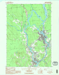 1988 Old Town1988 Print · USGSThe Penobscot and Stillwater rivers converge here in the 1980s, framing the industrial and academic centers of Old Town and the Univ of Maine. Trace riverfront history across Marsh Island or locate smaller locales like Great Works and Stillwater.2 unique versions available
 - 1988 Map of Greenbush
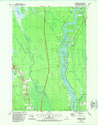 1988 Greenbush1988 Print · USGSThe Penobscot River flows through central Maine in the late eighties, carving a landscape of named islands and boggy lowlands. Trace local family history at Cedarvale Cemetery or explore the settlements of Greenbush, Argyle, and Costigan.2 unique versions available
 - 1988 Map of Otter Chain Ponds
 1988 Otter Chain Ponds1988 Print · USGSPenobscot County in the late 1980s reveals a vast landscape of wetlands and watercourses at the junction of several towns. Researchers can trace the complex hydrology of Sunkhaze Stream and identify early tracks near Haynes Ridge and Spencer Meadow.
End of results
Showing maps 1-8 of 8
Top cities near Milford
- Bangor historical maps
- Orono historical maps
- Brewer historical maps
- Hampden historical maps
- Old Town historical maps
- Glenburn historical maps
See more
Top neighborhoods of Milford
Frequently asked questions
- What are the different types of historical maps available for Milford?
- What is the oldest map of Milford?
- Where can I purchase historical maps of Milford for my home or office?
- Where can I download high-res historical maps of Milford?
- Are there historical topographic maps available for Milford?
- Is there historical aerial imagery available for Milford?
- Where are historical maps of Milford sourced from?