1950s Maps of Greenville, Maine
Explore 6 historic maps of Greenville from the 1950s. These maps offer a rare glimpse into what life looked like during the 1950s — showing old roads, neighborhoods, homes, and landmarks that have changed or disappeared over time.
Whether you're researching your family's past, planning a metal detecting trip, or studying how Greenville's landscape evolved across the 1950s, these high-resolution maps are a powerful tool for exploring the history of this region.
- Focus on a specific era: All maps on this page are from the 1950s, giving you a focused view of this time period.
- See what’s changed: Compare century-old streets, trails, and buildings to today's modern landscape using overlays and satellite layers.
- Research with precision: Use these maps for genealogy, historical research, land use analysis, or educational projects.
- View, download, or print: Maps are fully viewable online in high resolution, and can be downloaded or printed for your own records.
Start exploring Greenville's history through authentic maps from the 1950s. This is your window into the past.
Greenville, ME maps
(6)- 1950 Map of Sebec Lake, 1952 Print
 1950 Sebec Lake1952 Print · USGSMid-century Piscataquis County reveals a landscape of slate quarries, remote rail outposts, and wilderness trails just after the war. You can trace the mining history near Monson at Hillside Quarry or follow the Canadian Pacific line to the settlement at Onawa.7 unique versions available
 - 1951 Map of Greenville, 1952 Print
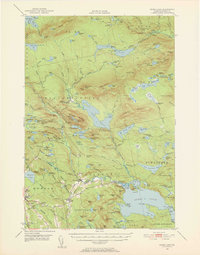
 1951 Greenville1952 Print · USGSThe Moosehead Lake region flourished as a rail and timber hub in the early fifties, where the northern woods met the water. Trace the path of the Appalachian Trail or locate the junction of the Canadian Pacific Railroad and Bangor and Aroostook Railroad near Greenville.6 unique versions available
 - 1952 Map of First Roach Pond, 1954 Print
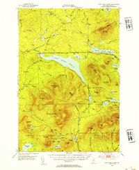 1952 First Roach Pond1954 Print · USGSThe Maine wilderness near Kokadjo is captured here in the early fifties, showing a landscape of timber grants and remote ponds. Researchers can trace the original path of the Appalachian Trail and locate local landmarks like the State Fish Hatchery and VABM Lookout Tower.6 unique versions available
 - 1954 Map of Millinocket, 1968 Print
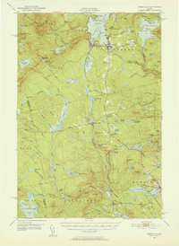
 1954 Millinocket1968 Print · USGSMaine's North Woods and the Penobscot Valley are captured here during the mid-century era of logging and rail dominance. You can trace the path of the Bangor and Aroostook Railroad through timber towns like Millinocket, Mattawamkeag, and Silver Ridge.3 unique versions available
 - 1957 Map of Moosehead Lake, 1959 Print
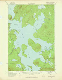 1957 Moosehead Lake1959 Print · USGSMoosehead Lake's central reaches are captured here in the late fifties, showing a wilderness of large islands and timber grants before heavy modern development. Researchers can trace the Canadian Pacific rail line and locate landmarks like the Mt Kineo Lookout Tower and Deer Head Farm.4 unique versions available
 - 1958 Map of Millinocket
 1958 Millinocket1958 Print · USGSMaine's North Woods and the Penobscot river valley are captured here in the mid-1950s, showing a landscape of timber, rail, and wild waters. Researchers can trace the legacy of the Canadian Pacific railroad and find historic settlements like Millinocket, Sherman Station, and Mattawamkeag.
End of results
Showing maps 1-6 of 6
Top cities near Greenville
- Guilford historical maps
- Abbot historical maps
- Monson historical maps
- Shirley historical maps
- Bowerbank historical maps
- Willimantic historical maps
See more
Top neighborhoods of Greenville
Frequently asked questions
- What are the different types of historical maps available for Greenville?
- What is the oldest map of Greenville?
- Where can I purchase historical maps of Greenville for my home or office?
- Where can I download high-res historical maps of Greenville?
- Are there historical topographic maps available for Greenville?
- Is there historical aerial imagery available for Greenville?
- Where are historical maps of Greenville sourced from?