Old Maps of T10 R13 WELS, Maine for Genealogy
Trace your family roots with 34 historic maps of T10 R13 WELS. These high-res maps reveal old neighborhoods, homesites, landmarks, and streets — helping you uncover where your ancestors lived and how the area evolved over time.
- Explore historic neighborhoods: Identify where your relatives may have lived in the 1800s or 1900s.
- Compare maps over time: Trace the changes in streets, buildings, and landmarks for multi-generational research.
- Perfect for genealogy & ancestry research: Used by family historians and researchers to map out lineage and migration.
These maps are an incredible resource for exploring your personal connection to T10 R13 WELS's past.
T10 R13 WELS, ME maps
(34)- 1932 Map of Umsaskis Lake
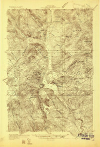 1932 Umsaskis Lake1932 Print · USGSThe northern Maine wilderness of the early 1930s is documented here as a landscape of timber camps and remote warden stations. Researchers can trace the era's logging infrastructure through sites like Churchill Depot, Harvey Farm, and the American Realty Depot Camp.4 unique versions available
 - 1935 Map of Umsaskis Lake
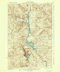 1935 Umsaskis Lake1935 Print · USGSThe Allagash wilderness in the early 1930s is documented here through its logging camps and river-driving infrastructure. Genealogists and researchers can trace remote outposts like Harvey Farm, the American Realty Depot Camp, and the Paquetta Sch.3 unique versions available
 - 1954 Map of Churchill Lake, 1955 Print
 1954 Churchill Lake1955 Print · USGSThe Allagash wilderness in the mid-fifties remained a landscape of timber history and remote sporting camps. Trace the famous Tramway between the big lakes or locate old forest outposts like Zeigler Camp Ground and the Lock Dam.2 unique versions available
 - 1954 Map of Presque Isle, 1968 Print
 1954 Presque Isle1968 Print · USGSNorth Woods logging and rail history come alive in this mid-century survey of the Maine-Quebec borderlands. Genealogists and historians can trace the Bangor and Aroostook railroad through timber hubs like Ashland, Smyrna Mills, and Presque Isle.2 unique versions available
 - 1958 Map of Presque Isle
 1958 Presque Isle1958 Print · USGSThe Aroostook timber and potato country is captured here during the late fifties, showing the vital rail-to-river network of Northern Maine. Genealogists and historians can trace the Bangor & Aroostook RR through Mapleton and Ashland, or locate remote sites like Chamberlain Farm and Seven Islands.
 - 1960 Map of Presque Isle
 1960 Presque Isle1960 Print · USGSNorthern Maine during the mid-century was a land of timber, rails, and strategic airfields. Genealogists and historians can trace the growth of Presque Isle and Ashland or explore the remote northern reaches of Baxter State Park and Presque Isle AFB.3 unique versions available
 - 1962 Map of Churchill Lake, 1964 Print
 1962 Churchill Lake1964 Print · USGSMaine's North Woods in the early sixties remained a landscape of historic timber transport and remote lake systems. Researchers can trace the Old Railroad Grade and find the Tramway State Forest Service Camp and Churchill Depot.3 unique versions available
 - 1986 Map of Chamberlain Lake
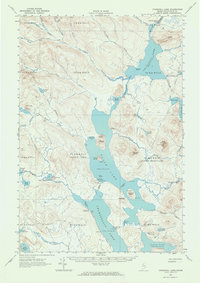
 1986 Chamberlain Lake1986 Print · USGSThe Maine North Woods in the mid-eighties appear here as a land of protected wilderness and logging heritage, centered on the Allagash Wilderness Waterway. Researchers can trace the historic Tramway at Chamberlain Lake and locate old outposts like Churchill Depot.
 - 1986 Map of Umsaskis Lake West, 1987 Print
 1986 Umsaskis Lake West1987 Print · USGSNorthern Maine's backcountry comes alive in the mid-1980s, centered on the protected Allagash Wilderness State Waterway. Researchers can trace the timber and conservation landscape through the Ranger Sta, remote Campsites, and heights of Squirrel Mountain.
 - 1986 Map of Umsaskis Lake East, 1987 Print
 1986 Umsaskis Lake East1987 Print · USGSThe North Maine Woods are captured here in the mid-1980s, centered on the protected waters of the Allagash Wilderness State Waterway. Trace the remote logging roads and waterways of the backcountry, from Chase Rapids and Umsaskis Lake to various river Campsite locations.
 - 1989 Map of Clarkson Pond
 1989 Clarkson Pond1989 Print · USGSNorth Piscataquis County is documented in the late eighties as a managed wilderness of unorganized townships and state waterways. Trace the remote drainage systems of Lower Russell Pond and Clarkson Pond or locate industrial sites like the Shale Pit near Eagle Lake.
 - 1989 Map of Churchill Lake
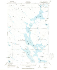
 1989 Churchill Lake1989 Print · USGSThe North Maine Woods in the late eighties are defined here by the vast waters of the Allagash Wilderness State Waterway. Researchers can trace the remote logging infrastructure and interior campsites from Churchill Depot south across Johns Bridge to the head of Eagle Lake.2 unique versions available
 - 1993 Map of Clayton Lake, 1994 Print
 1993 Clayton Lake1994 Print · USGSThe North Woods along the Maine and Quebec border remained a vast wilderness of timber and water in the early nineties. Researchers can trace historic river crossings and remote outposts like Ninemile Bridge, Saint-Pamphile, and the Harvey Farm.
 - 1994 Map of Chamberlain Lake
 1994 Chamberlain Lake1994 Print · USGSThe North Maine Woods in the early nineties remained a network of logging outposts and protected waterways. You can trace the historic logging infrastructure at Churchill Depot, the portage at Tramway, and remote landings such as Telos Landing.
 - 2011 Map of Umsaskis Lake East, 2011 Print
 2011 Umsaskis Lake East2011 Print · USGSCovers T10 R13 WELS, including T10 R12 WELS, T11 R13 WELS, and other nearby areas
 - 2011 Map of Churchill Lake, 2011 Print
 2011 Churchill Lake2011 Print · USGSCovers T10 R13 WELS, including Eagle Lake Township, T10 R12 WELS, and other nearby areas
 - 2011 Map of Umsaskis Lake West, 2011 Print
 2011 Umsaskis Lake West2011 Print · USGSCovers T10 R13 WELS, including T10 R14 WELS, Clayton Lake Township, and other nearby areas
 - 2011 Map of Clarkson Pond, 2011 Print
 2011 Clarkson Pond2011 Print · USGSCovers T10 R13 WELS, including Eagle Lake Township, T9 R14 WELS, and other nearby areas
 - 2014 Map of Churchill Lake, 2014 Print
 2014 Churchill Lake2014 Print · USGSCovers T10 R13 WELS, including Eagle Lake Township, T10 R12 WELS, and other nearby areas
 - 2014 Map of Clarkson Pond, 2014 Print
 2014 Clarkson Pond2014 Print · USGSCovers T10 R13 WELS, including Eagle Lake Township, T9 R14 WELS, and other nearby areas
 - 2014 Map of Umsaskis Lake West, 2014 Print
 2014 Umsaskis Lake West2014 Print · USGSCovers T10 R13 WELS, including T10 R14 WELS, Clayton Lake Township, and other nearby areas
 - 2014 Map of Umsaskis Lake East, 2014 Print
 2014 Umsaskis Lake East2014 Print · USGSCovers T10 R13 WELS, including T10 R12 WELS, T11 R13 WELS, and other nearby areas
 - 2018 Map of Umsaskis Lake West, 2018 Print
 2018 Umsaskis Lake West2018 Print · USGSCovers T10 R13 WELS, including T10 R14 WELS, Clayton Lake Township, and other nearby areas
 - 2018 Map of Churchill Lake, 2018 Print
 2018 Churchill Lake2018 Print · USGSCovers T10 R13 WELS, including Eagle Lake Township, T10 R12 WELS, and other nearby areas
 - 2018 Map of Clarkson Pond, 2018 Print
 2018 Clarkson Pond2018 Print · USGSCovers T10 R13 WELS, including Eagle Lake Township, T9 R14 WELS, and other nearby areas
Showing maps 1-25 of 34
Frequently asked questions
- What are the different types of historical maps available for T10 R13 WELS?
- What is the oldest map of T10 R13 WELS?
- Where can I purchase historical maps of T10 R13 WELS for my home or office?
- Where can I download high-res historical maps of T10 R13 WELS?
- Are there historical topographic maps available for T10 R13 WELS?
- Is there historical aerial imagery available for T10 R13 WELS?
- Where are historical maps of T10 R13 WELS sourced from?