1980s Maps of Williamsburg Township, Maine
Explore 5 historic maps of Williamsburg Township from the 1980s. These maps offer a rare glimpse into what life looked like during the 1980s — showing old roads, neighborhoods, homes, and landmarks that have changed or disappeared over time.
Whether you're researching your family's past, planning a metal detecting trip, or studying how Williamsburg Township's landscape evolved across the 1980s, these high-resolution maps are a powerful tool for exploring the history of this region.
- Focus on a specific era: All maps on this page are from the 1980s, giving you a focused view of this time period.
- See what’s changed: Compare century-old streets, trails, and buildings to today's modern landscape using overlays and satellite layers.
- Research with precision: Use these maps for genealogy, historical research, land use analysis, or educational projects.
- View, download, or print: Maps are fully viewable online in high resolution, and can be downloaded or printed for your own records.
Start exploring Williamsburg Township's history through authentic maps from the 1980s. This is your window into the past.
Williamsburg Township, ME maps
(5)- 1986 Map of Dover-Foxcroft
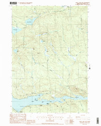
 1986 Dover-Foxcroft1986 Print · USGSPiscataquis County at the edge of the great Maine woods is documented here in the mid-1980s, centered on the river-and-rail hubs of the interior. Trace the industrial footprints of Dover South Mills, the rail yards at Brownville Junction, or the historic Katahdin Iron Works.
 - 1988 Map of Silver Lake
 1988 Silver Lake1988 Print · USGSPiscataquis County's industrial and wilderness history meet in the late eighties near the Katahdin Iron Works State Park. Researchers can trace the geography of old timber grants and remote sporting camps like Pine Camp or the topography surrounding Silver Lake.
 - 1988 Map of Sebec Lake East
 1988 Sebec Lake East1988 Print · USGSThe eastern reach of Sebec Lake is captured here in the late 1980s, revealing a landscape defined by its deep coves and shoreline landings. Genealogists and researchers can trace the vicinity of Barnard and waterfront sites like Greeleys Landing or Parson Landing.2 unique versions available
 - 1988 Map of Ebeemee Mountain
 1988 Ebeemee Mountain1988 Print · USGSPiscataquis County's interior wilderness is captured here in the late twentieth century, showing the intersection of Maine's timberlands and industrial history. Researchers can trace the Mooresville Road to the Mooresville (Site) or locate remote spots like Strout Camp and the small settlement at Prairie.
 - 1988 Map of Brownville Junction
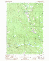 1988 Brownville Junction1988 Print · USGSPiscataquis County timber and rail lands come into focus in the late eighties at the meeting of the two river branches. Genealogists and local historians can trace family-named landmarks like Town Farm Hill or the small settlement at Barnard Corner.
End of results
Showing maps 1-5 of 5
Top cities near Williamsburg Township
- Dover-Foxcroft historical maps
- Milo historical maps
- Charleston historical maps
- Sangerville historical maps
- Guilford historical maps
- Bradford historical maps
See more
Frequently asked questions
- What are the different types of historical maps available for Williamsburg Township?
- What is the oldest map of Williamsburg Township?
- Where can I purchase historical maps of Williamsburg Township for my home or office?
- Where can I download high-res historical maps of Williamsburg Township?
- Are there historical topographic maps available for Williamsburg Township?
- Is there historical aerial imagery available for Williamsburg Township?
- Where are historical maps of Williamsburg Township sourced from?