1980s Maps of Big W Township, Maine
Explore 5 historic maps of Big W Township from the 1980s. These maps offer a rare glimpse into what life looked like during the 1980s — showing old roads, neighborhoods, homes, and landmarks that have changed or disappeared over time.
Whether you're researching your family's past, planning a metal detecting trip, or studying how Big W Township's landscape evolved across the 1980s, these high-resolution maps are a powerful tool for exploring the history of this region.
- Focus on a specific era: All maps on this page are from the 1980s, giving you a focused view of this time period.
- See what’s changed: Compare century-old streets, trails, and buildings to today's modern landscape using overlays and satellite layers.
- Research with precision: Use these maps for genealogy, historical research, land use analysis, or educational projects.
- View, download, or print: Maps are fully viewable online in high resolution, and can be downloaded or printed for your own records.
Start exploring Big W Township's history through authentic maps from the 1980s. This is your window into the past.
Big W Township, ME maps
(5)- 1985 Map of Moosehead Lake, 1986 Print
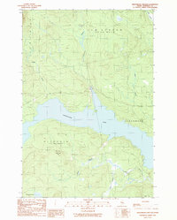
 1985 Moosehead Lake1986 Print · USGSThe Maine North Woods in the 1980s remain a landscape of vast timberlands, railroads, and the sprawling waters of the state's largest lake. Researchers can trace the Canadian Pacific line through Rockwood or locate historical townships from Seboomook to Kokadjo.
 - 1989 Map of Seboomook Lake East
 1989 Seboomook Lake East1989 Print · USGSSomerset County, Maine, is captured here in the late twentieth century as a landscape of managed timberlands and expansive waters. Researchers can trace the network of logging roads and waterways like Seboomook Lake, Sevenmile Hill, and Carry Brook.
 - 1989 Map of North East Carry
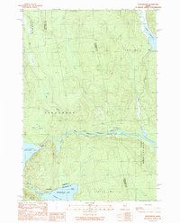
 1989 North East Carry1989 Print · USGSThe northern reaches of Moosehead Lake are captured in the late 1980s, showcasing the traditional land grants and portage points of the Maine woods. Researchers can trace historical boundaries like the East Middlesex Canal Grant or locate specific sites like Folsom Farm and North East Carry.
 - 1989 Map of Seboomook
 1989 Seboomook1989 Print · USGSThe North Maine Woods at the close of the 1980s reveal a landscape shaped by timber and water management near the settlement of Seboomook. Researchers can trace the industrial Golden Road and locate historical water controls like Old Roll Dam and Seboomook Dam.
 - 1989 Map of Socatean Bay
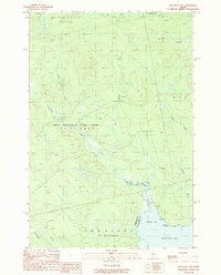 1989 Socatean Bay1989 Print · USGSThe northwestern reaches of Moosehead Lake are captured in the late 1980s, showcasing a landscape of working timberlands and remote watercourses. Researchers can trace the bounds of the West Middlesex Canal Grant and locate features like Socatean Point and Tomhegan Stream.
End of results
Showing maps 1-5 of 5
Top neighborhoods of Big W Township
Frequently asked questions
- What are the different types of historical maps available for Big W Township?
- What is the oldest map of Big W Township?
- Where can I purchase historical maps of Big W Township for my home or office?
- Where can I download high-res historical maps of Big W Township?
- Are there historical topographic maps available for Big W Township?
- Is there historical aerial imagery available for Big W Township?
- Where are historical maps of Big W Township sourced from?