1980s Maps of Caratunk, Maine
Explore 7 historic maps of Caratunk from the 1980s. These maps offer a rare glimpse into what life looked like during the 1980s — showing old roads, neighborhoods, homes, and landmarks that have changed or disappeared over time.
Whether you're researching your family's past, planning a metal detecting trip, or studying how Caratunk's landscape evolved across the 1980s, these high-resolution maps are a powerful tool for exploring the history of this region.
- Focus on a specific era: All maps on this page are from the 1980s, giving you a focused view of this time period.
- See what’s changed: Compare century-old streets, trails, and buildings to today's modern landscape using overlays and satellite layers.
- Research with precision: Use these maps for genealogy, historical research, land use analysis, or educational projects.
- View, download, or print: Maps are fully viewable online in high resolution, and can be downloaded or printed for your own records.
Start exploring Caratunk's history through authentic maps from the 1980s. This is your window into the past.
Caratunk, ME maps
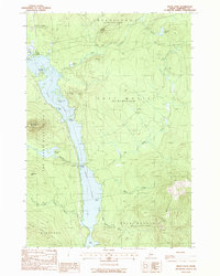
(7)- 1986 Map of Flagstaff Lake
 1986 Flagstaff Lake1986 Print · USGSThe Maine North Woods and the Dead River valley are captured here in the mid-1980s, an era of established hydroelectric lakes and outdoor recreation. Genealogists and researchers can trace the vicinity of Kennebago Settlement, Langtown Mill, and the villages of Stratton and Eustis.
 - 1986 Map of Dover-Foxcroft
 1986 Dover-Foxcroft1986 Print · USGSPiscataquis County at the edge of the great Maine woods is documented here in the mid-1980s, centered on the river-and-rail hubs of the interior. Trace the industrial footprints of Dover South Mills, the rail yards at Brownville Junction, or the historic Katahdin Iron Works.
 - 1988 Map of The Forks
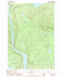
 1988 The Forks1988 Print · USGSThe Forks region in the late 1980s reveals the rugged confluence of the Kennebec River and Dead River. You can trace the path of the Appalachian National Scenic Trail and locate landmarks like Moxie Falls and Pleasant Pond.2 unique versions available
 - 1988 Map of Moxie Pond
 1988 Moxie Pond1988 Print · USGSSomerset County's wilderness is captured here in the late eighties, centered on the dramatic length of Moxie Pond. Hikers and historians can trace the Appalachian National Scenic Trail as it passes Bald Mountain and the lakeside stop at Troutdale.
 - 1989 Map of East Carry Pond
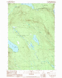 1989 East Carry Pond1989 Print · USGSSomerset County's interior wilderness is captured here in the late 1980s, centered on the ancient portage routes of the Carry Ponds. Hikers and historians can trace the Appalachian National Scenic Trail past Arnolds Point and the remote shores of Pierce Pond.
 - 1989 Map of Caratunk
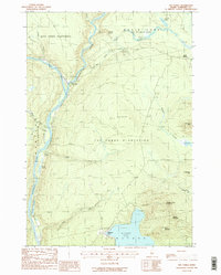
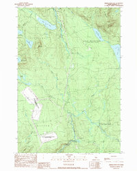
 1989 Caratunk1989 Print · USGSThe Kennebec River valley and the village of Caratunk are seen here in the late 1980s as the river widens into Wyman Lake. Outdoorsmen and local historians can trace the Appalachian Trail, find the local Cem, and locate the Historic Site along the water.
 - 1989 Map of Dimmick Mountain
 1989 Dimmick Mountain1989 Print · USGSSomerset County was characterized by a unique mix of remote wilderness and Cold War-era infrastructure in the late eighties. Researchers can trace the Appalachian Trail as it passes near Baker Pond and the extensive Moscow Air Force Station Transmit Site.
End of results
Showing maps 1-7 of 7
Top cities near Caratunk
- Solon historical maps
- Kingfield historical maps
- Athens historical maps
- Bingham historical maps
- Moscow historical maps
- Shirley historical maps
See more
Top neighborhoods of Caratunk
Frequently asked questions
- What are the different types of historical maps available for Caratunk?
- What is the oldest map of Caratunk?
- Where can I purchase historical maps of Caratunk for my home or office?
- Where can I download high-res historical maps of Caratunk?
- Are there historical topographic maps available for Caratunk?
- Is there historical aerial imagery available for Caratunk?
- Where are historical maps of Caratunk sourced from?