1920s Maps of Calais, Maine
Explore 2 historic maps of Calais from the 1920s. These maps offer a rare glimpse into what life looked like during the 1920s — showing old roads, neighborhoods, homes, and landmarks that have changed or disappeared over time.
Whether you're researching your family's past, planning a metal detecting trip, or studying how Calais's landscape evolved across the 1920s, these high-resolution maps are a powerful tool for exploring the history of this region.
- Focus on a specific era: All maps on this page are from the 1920s, giving you a focused view of this time period.
- See what’s changed: Compare century-old streets, trails, and buildings to today's modern landscape using overlays and satellite layers.
- Research with precision: Use these maps for genealogy, historical research, land use analysis, or educational projects.
- View, download, or print: Maps are fully viewable online in high resolution, and can be downloaded or printed for your own records.
Start exploring Calais's history through authentic maps from the 1920s. This is your window into the past.
Calais, ME maps
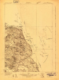
(2)- 1929 Map of Calais
 1929 Calais1929 Print · USGSThe international border along the St. Croix River comes alive in the late 1920s, showing a landscape defined by rail lines and river industry. Genealogists and historians can trace the foundations of local life at Grove PO, Damon Sch, and the riverside works at Milltown.4 unique versions available
 - 1929 Map of Robbinston
 1929 Robbinston1929 Print · USGSThe Maine-New Brunswick border comes to life in the late twenties as this survey traces the international waters of the St Croix River. Genealogists and historians can locate rural landmarks like South Robbinston Sch, Charlotte Sta, and several coastal lighthouses.3 unique versions available
End of results
Showing maps 1-2 of 2
Top cities near Calais
- Baileyville historical maps
- Eastport historical maps
- Lubec historical maps
- Perry historical maps
- Pembroke historical maps
- Pleasant Point / Sipayik historical maps
See more
Top neighborhoods of Calais
Frequently asked questions
- What are the different types of historical maps available for Calais?
- What is the oldest map of Calais?
- Where can I purchase historical maps of Calais for my home or office?
- Where can I download high-res historical maps of Calais?
- Are there historical topographic maps available for Calais?
- Is there historical aerial imagery available for Calais?
- Where are historical maps of Calais sourced from?