1940s Maps of Calais, Maine
Explore 4 historic maps of Calais from the 1940s. These maps offer a rare glimpse into what life looked like during the 1940s — showing old roads, neighborhoods, homes, and landmarks that have changed or disappeared over time.
Whether you're researching your family's past, planning a metal detecting trip, or studying how Calais's landscape evolved across the 1940s, these high-resolution maps are a powerful tool for exploring the history of this region.
- Focus on a specific era: All maps on this page are from the 1940s, giving you a focused view of this time period.
- See what’s changed: Compare century-old streets, trails, and buildings to today's modern landscape using overlays and satellite layers.
- Research with precision: Use these maps for genealogy, historical research, land use analysis, or educational projects.
- View, download, or print: Maps are fully viewable online in high resolution, and can be downloaded or printed for your own records.
Start exploring Calais's history through authentic maps from the 1940s. This is your window into the past.
Calais, ME maps
(4)- 1949 Map of Robbinston, 1952 Print
 1949 Robbinston1952 Print · USGSThe international boundary at the St Croix River comes to life in the late 1940s, showing the connection between Maine and New Brunswick. Researchers can trace the Canadian Pacific rail line, locate the Back District Ch, or find the U S Customs post at Robbinston.3 unique versions available
 - 1949 Map of Calais, 1952 Print
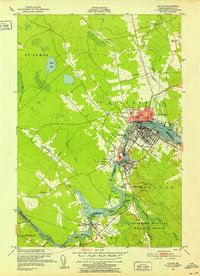 1949 Calais1952 Print · USGSLife along the international border in the late 1940s centered on the St Croix River and its shared industrial heritage. Researchers can trace the rail lines of the Maine Central and find localized landmarks like Upper Mills, Campbells Siding, and the St Croix Golf Course.3 unique versions available
 - 1949 Map of Red Beach, 1952 Print
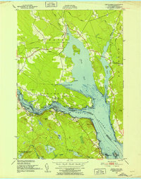
 1949 Red Beach1952 Print · USGSThe St. Croix River waterfront and the rugged lake country of Washington County are shown here in the years following the war. Researchers can locate the South Robbinston Ridge Sch, the Robbinston Ridge Ch, and local landmarks like Little Dochet Island and Fairview Cem.3 unique versions available
 - 1949 Map of Devils Head, 1952 Print
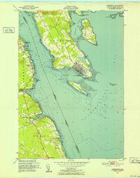
 1949 Devils Head1952 Print · USGSThe international waters of the St Croix River and Oak Bay are documented here just after the war, showing the borderlands of Maine and New Brunswick. Researchers can trace historic maritime activity through markers like Whitlocks Mill, the Mark Lighthouse, and Cribbing Ruins.4 unique versions available
End of results
Showing maps 1-4 of 4
Top cities near Calais
- Baileyville historical maps
- Eastport historical maps
- Lubec historical maps
- Perry historical maps
- Pembroke historical maps
- Pleasant Point / Sipayik historical maps
See more
Top neighborhoods of Calais
Frequently asked questions
- What are the different types of historical maps available for Calais?
- What is the oldest map of Calais?
- Where can I purchase historical maps of Calais for my home or office?
- Where can I download high-res historical maps of Calais?
- Are there historical topographic maps available for Calais?
- Is there historical aerial imagery available for Calais?
- Where are historical maps of Calais sourced from?