1970s Maps of Danforth, Maine
Explore 4 historic maps of Danforth from the 1970s. These maps offer a rare glimpse into what life looked like during the 1970s — showing old roads, neighborhoods, homes, and landmarks that have changed or disappeared over time.
Whether you're researching your family's past, planning a metal detecting trip, or studying how Danforth's landscape evolved across the 1970s, these high-resolution maps are a powerful tool for exploring the history of this region.
- Focus on a specific era: All maps on this page are from the 1970s, giving you a focused view of this time period.
- See what’s changed: Compare century-old streets, trails, and buildings to today's modern landscape using overlays and satellite layers.
- Research with precision: Use these maps for genealogy, historical research, land use analysis, or educational projects.
- View, download, or print: Maps are fully viewable online in high resolution, and can be downloaded or printed for your own records.
Start exploring Danforth's history through authentic maps from the 1970s. This is your window into the past.
Danforth, ME maps
(4)- 1975 Map of Danforth NE, 1980 Print
 1975 Danforth NE1980 Print · USGSThe international boundary at the Maine-New Brunswick line is captured here in the mid-seventies, showing the lakeside settlements along the eastern border. Genealogists can trace early homestead footprints near Danforth and landing sites like Butterfield Landing.
 - 1975 Map of Danforth NW, 1980 Print
 1975 Danforth NW1980 Print · USGSAroostook County's wooded interior is documented in the mid-1970s, showcasing the remote settlements and river systems of northern Maine. Researchers can trace land use around South Bancroft and locate properties between Mattawamkeag River and Lower Hot Brook Lake.
 - 1975 Map of Danforth SE, 1980 Print
 1975 Danforth SE1980 Print · USGSThe Maine woods surrounding Baskahegan Lake are captured in high detail during the mid-seventies. Researchers can trace the winding course of Baskahegan Stream as it flows toward the small settlement of Eaton.
 - 1975 Map of Danforth SW, 1980 Print
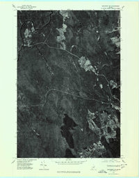
 1975 Danforth SW1980 Print · USGSThe dense forests of Washington County are seen in high detail during the mid-seventies, showing the timberlands and waterways near Danforth. Researchers can trace the rugged topography of Stetson Mountain and the winding paths of the West Branch and East Branch.
End of results
Showing maps 1-4 of 4
Top cities near Danforth
- Weston historical maps
- Prentiss Township historical maps
- Topsfield historical maps
- Orient historical maps
- Carroll Plantation historical maps
- Reed Plantation historical maps
See more
Top neighborhoods of Danforth
Frequently asked questions
- What are the different types of historical maps available for Danforth?
- What is the oldest map of Danforth?
- Where can I purchase historical maps of Danforth for my home or office?
- Where can I download high-res historical maps of Danforth?
- Are there historical topographic maps available for Danforth?
- Is there historical aerial imagery available for Danforth?
- Where are historical maps of Danforth sourced from?