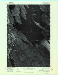
1975 Map of Danforth NE
USGS Topo · Published 1980About this map
The international border between the United States and Canada cuts directly through the waters of Chiputneticook Lake, defining the eastern edge of this mid-1970s orthophotoquad. This unique perspective, derived from aerial photography, captures the dense forest and complex shoreline of eastern Maine near the village of Danforth. The landscape is dominated by the sprawling interconnected basins of Grand Lake and Sucker Lake, where small clearings for human activity appear as distinct contrasts against the dark timber. Local landmarks such as Butterfield Landing and the elevated terrain of Greenland Ridge provide spatial orientation for the scattered settlements and access points along the water. Unlike traditional line-drawn maps, this image-based survey highlights the exact texture of the woods and the precise configuration of the lakes near the Maine and New Brunswick line.
Find a feature on this map
11 named features on this map. Tap any name to fly to it.
Don’t see what you’re looking for? This feature index may not catch every label — zoom into the map to look around manually.
Map Details
Editions of this 1975 Danforth NE Map
This is the sole edition of this map. No revisions or reprints were ever made.
Other maps of this area

1940 · Danforth
USGS Topo · 1:62,500

1940 · Amity
USGS Topo · 1:62,500

1940 · Forest
USGS Topo · 1:62,500

1941 · Danforth
USGS Topo · 1:62,500

1941 · Amity
USGS Topo · 1:62,500

1942 · Forest
USGS Topo · 1:62,500

1943 · Danforth
USGS Topo · 1:62,500

1943 · Amity
USGS Topo · 1:62,500

1957 · Fredericton
USGS Topo · 1:250,000
1958 · Danforth
USGS Topo · 1:62,500