Old Maps of Steuben, Maine for Hiking & Exploration
Hike through history with 53 historic maps of Steuben. Explore old trails, ghost towns, and forgotten backroads — perfect for outdoor adventurers and local explorers.
- Rediscover forgotten places: Map out old mining camps, roads, and footpaths that no longer exist on modern maps.
- Layer with modern tools: Combine with LiDAR or satellite views to plan hikes through historical terrain.
- Made for exploration: Popular among hikers, overlanders, and local history lovers.
Use these maps to find adventure and explore the hidden past of Steuben.
Steuben, ME maps
(53)- 1902 Map of Cherryfield, 1962 Print
 1902 Cherryfield1962 Print · USGSCoastal Washington County comes alive in the early 1900s, showing the vital connections between tidal rivers and the rails. Genealogists can trace family roots in Milbridge and Cherryfield, or locate old landings along the Steamboat Route.2 unique versions available
 - 1904 Map of Cherryfield
 1904 Cherryfield1904 Print · USGSThe coastal and barrens landscape of Washington County is captured here at the start of the twentieth century. Genealogists and local historians can trace family-named points and early settlements from Cherryfield down to the shores of Narraguagus Bay and Millbridge.5 unique versions available
 - 1904 Map of Petit Manan
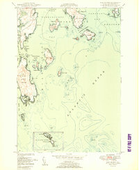
 1904 Petit Manan1904 Print · USGSThe rugged coastline of Washington and Hancock Counties comes alive in this early-century survey. Trace maritime history through the Steamboat Route and local landmarks like Corea, the Petit Manan I. L.H., and Bois Bubert Island.4 unique versions available
 - 1930 Map of Tunk Lake
 1930 Tunk Lake1930 Print · USGSHancock County was a landscape of timber and tide in the early 1930s, where the Maine Central rail line linked small coastal villages to the deep woods. Genealogists and historians can trace old homesteads in Donnells, rural education at Tunk Lake Sch, and the locations of sporting retreats like the Wichyup Club.
 - 1932 Map of Tunk Lake
 1932 Tunk Lake1932 Print · USGSThe coastal inlets and glacial highlands of Hancock County are meticulously detailed in the early 1930s. Researchers can trace the Maine Central rail line through Sullivan and locate vanished local landmarks like the Think Lake Sch and Wickypup Club.4 unique versions available
 - 1942 Map of Cherryfield
 1942 Cherryfield1942 Print · USGSCoastal Washington County in the early 1940s reveals a landscape of tidal bays and glacial barrens. Trace family roots and old land patterns in Cherryfield, Millbridge, and Harrington, or locate the scientific U S C & G SURVEY BASE LINE.
 - 1942 Map of Tunk Lake
 1942 Tunk Lake1942 Print · USGSHancock County’s inland peaks and coastal villages are captured here during the early 1940s, just as aerial photography began to modernize regional mapping. Researchers can locate the Tunk Lake Sch, coastal rail stops at Waukeag, and the prominent Fire Tower on Schoodic Mtn.
 - 1948 Map of Bangor
 1948 Bangor1948 Print · USGSThe Maine coast and its industrial river valleys are captured here shortly after the war, showing the vital shipping and rail hubs of the late 1940s. Genealogists and historians can trace the tracks of the Maine Central RR connecting Bangor, Augusta, and Old Town.
 - 1948 Map of Petit Manan, 1970 Print
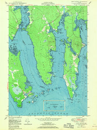 1948 Petit Manan1970 Print · USGSThe coastal village of Corea and the surrounding bays of Washington County are captured here in the years following World War II. Researchers can trace family sites near Corea Cem, identify early coastal landmarks like Eagle Hill, and explore the maritime geography of Steuben Hbr and Dyer Harbor.3 unique versions available
 - 1948 Map of Cherryfield, 1978 Print
 1948 Cherryfield1978 Print · USGSCoastal Washington County is captured here in the mid-twentieth century as the rail and river networks connected inland timber to the sea. Researchers can trace family sites in Cherryfield and Milbridge, or locate small historic settlements like Smithville and Unionville.
 - 1950 Map of Petit Manan
 1950 Petit Manan1950 Print · USGSCoastal Washington and Hancock counties are seen here at mid-century, defined by lobster harbors and the shifting tides of the Atlantic. Researchers can trace family names and local landmarks from Corea to Dyer Harbor, including the Corea Cem and Long Mill Cove.
 - 1950 Map of Cherryfield
 1950 Cherryfield1950 Print · USGSThe Narraguagus River valley and the coastal harbors of Washington County are shown here in the years following World War II. Local historians can trace the Maine Central railroad line through Unionville and Cherryfield, or locate family sites near Evergreen Cem and Steuben Harbor.
 - 1950 Map of Bois Bubert
 1950 Bois Bubert1950 Print · USGSThe Maine coastline near Addison and Harrington is captured here at the mid-century, showing a maritime landscape of islands and harbors. Researchers can trace family-named landmarks like Tom Leighton Point and find offshore aids like the lighthouse.3 unique versions available
 - 1950 Map of Petit Manan
 1950 Petit Manan1950 Print · USGSThe Downeast shoreline around Corea and Pigeon Hill is captured here at the mid-century, before modern development changed the coast. Trace family roots at Corea Cem and explore the historic Carrying Place between the harbor and the sea.
 - 1953 Map of Bois Bubert
 1953 Bois Bubert1953 Print · USGSCoastal Washington County is seen here in the early 1950s, a period defined by its intricate network of islands and working waterfronts. Researchers can trace historic maritime landmarks and family-named points like Tom Leighton Point, Jordans Delight, and the Trafton Halftide Beacon.
 - 1954 Map of Cherryfield
 1954 Cherryfield1954 Print · USGSThe Narraguagus River valley and the coastal reaches of Washington County are shown here in the mid-fifties. Researchers can trace the Maine Central rail line through rural outposts like Unionville and Smithville or locate the Evergreen Cem near the riverbanks.
 - 1956 Map of Bangor, 1966 Print
 1956 Bangor1966 Print · USGSMid-century Maine comes alive in this survey of the rugged coast and river valleys during the 1950s. Genealogists and historians can trace the vital rail corridors of the Maine Central RR connecting timber towns like Old Town to the coast at Bar Harbor.3 unique versions available
 - 1957 Map of Tunk Lake, 1959 Print
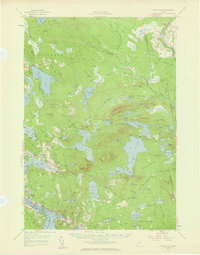 1957 Tunk Lake1959 Print · USGSCoastal Maine in the late 1950s shows a landscape defined by the Maine Central RR and tidal waters like Hog Bay. Local historians can trace family locations near Bayview Cem, the Union Ch, and settlements from Deblois to East Sullivan.4 unique versions available
 - 1960 Map of Bangor
 1960 Bangor1960 Print · USGSCentral Maine in the sixties reveals a landscape of river-powered industry and sprawling coastal island chains. Researchers can trace the rail corridors of the Maine Central or locate mid-century aviation landmarks like Dow Air Force Base.
 - 1961 Map of Bangor
 1961 Bangor1961 Print · USGSMid-century Maine comes alive through its busy river ports and rocky archipelagoes during a period of steady maritime and rail commerce. Researchers can trace the path of the Maine Central railroad and locate coastal landmarks from Acadia National Park to Vinalhaven Island.
 - 1961 Map of Eastport
 1961 Eastport1961 Print · USGSThe maritime borderlands of Maine and New Brunswick are captured here in the early sixties, showing a world defined by the Bay of Fundy. Researchers can trace the Maine Central Railroad to Machiasport or explore remote island villages like Grand Harbour and Welchpool.
 - 1969 Map of Eastport
 1969 Eastport1969 Print · USGSThe maritime borderlands of Washington County and New Brunswick appear in detail during the late sixties. Researchers can trace historic rail lines like the Maine Central Railroad and explore coastal settlements from Machias to St. Andrews.
 - 1976 Map of Eastport
 1976 Eastport1976 Print · USGSThe maritime borderlands of Maine and Nova Scotia come alive in this mid-seventies survey of the Downeast coast. Genealogists and historians can trace the shoreline settlements of Eastport, Lubec, and Machias, or cross the channel to find Acadian villages like Church Point and Meteghan Centre.
 - 1982 Map of Tunk Lake, 1983 Print
 1982 Tunk Lake1983 Print · USGSHancock and Washington Counties are captured in the early 1980s, centered on the vast waters of Tunk Lake. Researchers can trace the path of the Maine Central railroad and locate historical sites like Big Chief Camps or Goodwin Siding.
 - 1985 Map of Bangor
 1985 Bangor1985 Print · USGSMid-Maine during the mid-eighties centers on the industrial pulse of the Penobscot River and its critical rail connections. Genealogists and historians can trace the development of river towns from Old Town to Ellsworth and locate regional landmarks like Fort Knox State Park.
Showing maps 1-25 of 53
Top cities near Steuben
- Bar Harbor historical maps
- Mount Desert historical maps
- Gouldsboro historical maps
- Franklin historical maps
- Milbridge historical maps
- Sullivan historical maps
See more
Top neighborhoods of Steuben
- Pigeon Hill historical maps
- East Steuben historical maps
- Smithville historical maps
- Unionville historical maps
Frequently asked questions
- What are the different types of historical maps available for Steuben?
- What is the oldest map of Steuben?
- Where can I purchase historical maps of Steuben for my home or office?
- Where can I download high-res historical maps of Steuben?
- Are there historical topographic maps available for Steuben?
- Is there historical aerial imagery available for Steuben?
- Where are historical maps of Steuben sourced from?