1980s Maps of T8 R4 NBPP, Maine
Explore 5 historic maps of T8 R4 NBPP from the 1980s. These maps offer a rare glimpse into what life looked like during the 1980s — showing old roads, neighborhoods, homes, and landmarks that have changed or disappeared over time.
Whether you're researching your family's past, planning a metal detecting trip, or studying how T8 R4 NBPP's landscape evolved across the 1980s, these high-resolution maps are a powerful tool for exploring the history of this region.
- Focus on a specific era: All maps on this page are from the 1980s, giving you a focused view of this time period.
- See what’s changed: Compare century-old streets, trails, and buildings to today's modern landscape using overlays and satellite layers.
- Research with precision: Use these maps for genealogy, historical research, land use analysis, or educational projects.
- View, download, or print: Maps are fully viewable online in high resolution, and can be downloaded or printed for your own records.
Start exploring T8 R4 NBPP's history through authentic maps from the 1980s. This is your window into the past.
T8 R4 NBPP, ME maps
(5)- 1985 Map of Millinocket, 1986 Print
 1985 Millinocket1986 Print · USGSThe North Maine Woods were a landscape of industrial timber and wilderness recreation in the mid-eighties. Genealogists and researchers can trace local settlements and rail stops like Sherman Mills, Wytopitlock, and the Old Long A Siding near the Penobscot River.2 unique versions available
 - 1988 Map of Potter Hill
 1988 Potter Hill1988 Print · USGSMaine's north woods and plantations come into focus in the late 1980s, showcasing a landscape of timbered ridges and winding waterways. Researchers can locate the Cem in Prentiss Plt and trace family-named landmarks like Sam Rowe Ridge and Potter Hill.
 - 1988 Map of Stetson Mountain
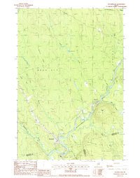
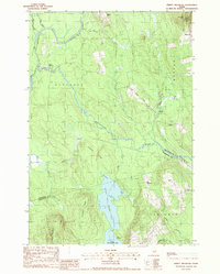
 1988 Stetson Mountain1988 Print · USGSMaine's northern interior during the late 1980s reveals a wilderness of high ridges and glacial lakes. Researchers can trace land divisions in T 8 R 4 N B P P or locate recreational landmarks like the Boat Ramp on Upper Hot Brook Lake.
 - 1988 Map of Wytopitlock
 1988 Wytopitlock1988 Print · USGSThe Mattawamkeag River valley in the late eighties serves as a vital corridor between the small outposts of Wytopitlock and Bancroft. Genealogists and historians can trace the bounds of Reed Plt and Drew Plt while identifying local landmarks like the Mill, Sherwood Mtn, and Palmer Deadwater.
 - 1988 Map of Jimmey Mountain
 1988 Jimmey Mountain1988 Print · USGSAroostook and Washington counties meet here in the late twentieth century, where river-carved timberlands define the landscape. Genealogists and historians can trace the Irish Settlement and South Bancroft or locate landmarks like Peekaboo Mtn and Lower Hot Brook Lake.
End of results
Showing maps 1-5 of 5
Top cities near T8 R4 NBPP
- Lee historical maps
- Danforth historical maps
- Springfield historical maps
- Weston historical maps
- Prentiss Township historical maps
- Topsfield historical maps
See more
Frequently asked questions
- What are the different types of historical maps available for T8 R4 NBPP?
- What is the oldest map of T8 R4 NBPP?
- Where can I purchase historical maps of T8 R4 NBPP for my home or office?
- Where can I download high-res historical maps of T8 R4 NBPP?
- Are there historical topographic maps available for T8 R4 NBPP?
- Is there historical aerial imagery available for T8 R4 NBPP?
- Where are historical maps of T8 R4 NBPP sourced from?