1980s Maps of Alfred, Maine
Explore 6 historic maps of Alfred from the 1980s. These maps offer a rare glimpse into what life looked like during the 1980s — showing old roads, neighborhoods, homes, and landmarks that have changed or disappeared over time.
Whether you're researching your family's past, planning a metal detecting trip, or studying how Alfred's landscape evolved across the 1980s, these high-resolution maps are a powerful tool for exploring the history of this region.
- Focus on a specific era: All maps on this page are from the 1980s, giving you a focused view of this time period.
- See what’s changed: Compare century-old streets, trails, and buildings to today's modern landscape using overlays and satellite layers.
- Research with precision: Use these maps for genealogy, historical research, land use analysis, or educational projects.
- View, download, or print: Maps are fully viewable online in high resolution, and can be downloaded or printed for your own records.
Start exploring Alfred's history through authentic maps from the 1980s. This is your window into the past.
Alfred, ME maps
(6)- 1983 Map of Mousam Lake
 1983 Mousam Lake1983 Print · USGSSouthern Maine's lake country in the early eighties shows a landscape of timbered ridges and glacial waters between the Ossipee and Mousam watersheds. Researchers can trace local settlements at Ross Corner and Shapleigh or locate family-named features like Abbott Mtn and Sherburne Lake.
 - 1983 Map of Waterboro, 1984 Print
 1983 Waterboro1984 Print · USGSWaterboro and the surrounding York County timberlands are captured here in the early eighties as the town's historic villages remained distinct. Genealogists and local historians can locate several family burial sites like Deering Cem and rural landmarks including Waterboro Old Corner and St Stephen the Martyr Mission.2 unique versions available
 - 1983 Map of Sanford, 1984 Print
 1983 Sanford1984 Print · USGSSanford and Springvale are shown in the early eighties as thriving centers of civic life and industry along the Mousam River. Trace local roots through Nasson College, the St Ignatius Cem, and landmarks like Goodall Park.2 unique versions available
 - 1983 Map of Alfred, 1984 Print
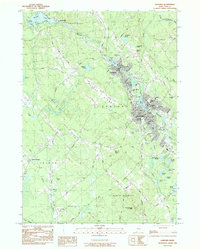
 1983 Alfred1984 Print · USGSYork County in the early 1980s reveals a balance of industrial growth and preserved wilderness along the Mousam River. Genealogists and historians can trace family locations near Evergreen Cem, the County Jail in Alfred, or the old mill sites at Spang Mills.2 unique versions available
 - 1985 Map of Kittery, 1986 Print
 1985 Kittery1986 Print · USGSThe Maine and New Hampshire borderlands are shown here in the mid-eighties, centered on the strategic Piscataqua River harbor. Genealogists and historians can trace the development of coastal towns like York or locate the sprawling Portsmouth Naval Shipyard and Pease Air Force Base.2 unique versions available
 - 1985 Map of Portland, 1986 Print
 1985 Portland1986 Print · USGSThe Maine coast and Sebago Lake region are captured in the mid-1980s, showcasing the transition from traditional maritime centers to a modern transportation hub. Genealogists and historians can trace rail lines like the Grand Trunk RR and find local landmarks such as the U.S. Marine Hospital or Old Orchard Beach.2 unique versions available
End of results
Showing maps 1-6 of 6
Top cities near Alfred
- Rochester historical maps
- Biddeford historical maps
- Sanford historical maps
- Saco historical maps
- Gorham historical maps
- Somersworth historical maps
See more
Top neighborhoods of Alfred
- North Alfred historical maps
- Alfred Mills historical maps
- Hazel Dell Apartments historical maps
- Colonial Mobile Home Park historical maps
- Wood's Edge Apartments historical maps
Frequently asked questions
- What are the different types of historical maps available for Alfred?
- What is the oldest map of Alfred?
- Where can I purchase historical maps of Alfred for my home or office?
- Where can I download high-res historical maps of Alfred?
- Are there historical topographic maps available for Alfred?
- Is there historical aerial imagery available for Alfred?
- Where are historical maps of Alfred sourced from?