1940s Maps of Barton, Maryland
Explore 3 historic maps of Barton from the 1940s. These maps offer a rare glimpse into what life looked like during the 1940s — showing old roads, neighborhoods, homes, and landmarks that have changed or disappeared over time.
Whether you're researching your family's past, planning a metal detecting trip, or studying how Barton's landscape evolved across the 1940s, these high-resolution maps are a powerful tool for exploring the history of this region.
- Focus on a specific era: All maps on this page are from the 1940s, giving you a focused view of this time period.
- See what’s changed: Compare century-old streets, trails, and buildings to today's modern landscape using overlays and satellite layers.
- Research with precision: Use these maps for genealogy, historical research, land use analysis, or educational projects.
- View, download, or print: Maps are fully viewable online in high resolution, and can be downloaded or printed for your own records.
Start exploring Barton's history through authentic maps from the 1940s. This is your window into the past.
Barton, MD maps
(3)- 1947 Map of Barton, 1964 Print
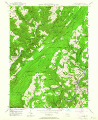 1947 Barton1964 Print · USGSMaryland's coal country comes into focus in the 1940s as industry and wilderness meet along the slopes of Big Savage Mountain. Genealogists can trace family sites from Barton to Pekin Nikep PO, including St Gabriels Cem and several local mines.4 unique versions available
 - 1948 Map of Cumberland
 1948 Cumberland1948 Print · USGSMid-century Appalachia and the Shenandoah Valley are shown in detail, documenting the industrial and transportation hubs of the tri-state area. Genealogists can trace family roots through settlements like Double Tollgate and Bunker Hill or along the Baltimore & Ohio RR.3 unique versions available
 - 1949 Map of Barton
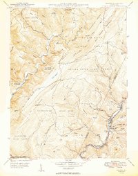 1949 Barton1949 Print · USGSThe industrial coal valleys of Western Maryland are shown here just after the war, where the Cumberland and Pennsylvania railroad links communities like Barton and Moscow. Genealogists can trace early landmarks like St Gabriels Cem and Bartlett Cem.2 unique versions available
End of results
Showing maps 1-3 of 3
Top cities near Barton
- Cumberland historical maps
- Frostburg historical maps
- Keyser historical maps
- La Vale historical maps
- Westernport historical maps
- Bel Air historical maps
See more
Frequently asked questions
- What are the different types of historical maps available for Barton?
- What is the oldest map of Barton?
- Where can I purchase historical maps of Barton for my home or office?
- Where can I download high-res historical maps of Barton?
- Are there historical topographic maps available for Barton?
- Is there historical aerial imagery available for Barton?
- Where are historical maps of Barton sourced from?