1940s Maps of La Plata, Maryland
Explore 3 historic maps of La Plata from the 1940s. These maps offer a rare glimpse into what life looked like during the 1940s — showing old roads, neighborhoods, homes, and landmarks that have changed or disappeared over time.
Whether you're researching your family's past, planning a metal detecting trip, or studying how La Plata's landscape evolved across the 1940s, these high-resolution maps are a powerful tool for exploring the history of this region.
- Focus on a specific era: All maps on this page are from the 1940s, giving you a focused view of this time period.
- See what’s changed: Compare century-old streets, trails, and buildings to today's modern landscape using overlays and satellite layers.
- Research with precision: Use these maps for genealogy, historical research, land use analysis, or educational projects.
- View, download, or print: Maps are fully viewable online in high resolution, and can be downloaded or printed for your own records.
Start exploring La Plata's history through authentic maps from the 1940s. This is your window into the past.
La Plata, MD maps
(3)- 1944 Map of Port Tobacco
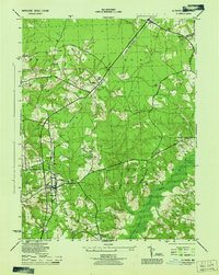
 1944 Port Tobacco1944 Print · USGSCharles County during the mid-1940s reveals a landscape of rural hamlets and emerging military infrastructure. Genealogists and local historians can trace family locations near Pomfret, the Mt Carmel Monastery, and the historic Port Tobacco PO.
 - 1944 Map of La Plata
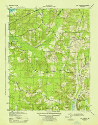
 1944 La Plata1944 Print · USGSCharles County during the Second World War remains a landscape of rural crossroads and strategic outposts. Researchers can trace the Popes Creek Branch rail line or locate family sites like Sacred Heart Church, Beantown, and the La Plata Army Radio Sta.
 - 1948 Map of Washington
 1948 Washington1948 Print · USGSThe Potomac and Chesapeake regions in the late 1940s reveal a landscape of expanding military reach and deep-rooted Tidewater settlements. Trace old rail corridors like the Richmond Fredericksburg & Potomac RR or locate landmarks like the Wakefield Washington Monument and St. Marys College.2 unique versions available
End of results
Showing maps 1-3 of 3
Top cities near La Plata
- Waldorf historical maps
- Fort Washington historical maps
- Woodlawn historical maps
- Lorton historical maps
- Fort Hunt historical maps
- Hybla Valley historical maps
See more
Top neighborhoods of La Plata
- Clarks Run historical maps
- Hickory Ridge historical maps
- Kent Square historical maps
- Kings Grant historical maps
- Maxwelton historical maps
- Old Colony historical maps
See more
Frequently asked questions
- What are the different types of historical maps available for La Plata?
- What is the oldest map of La Plata?
- Where can I purchase historical maps of La Plata for my home or office?
- Where can I download high-res historical maps of La Plata?
- Are there historical topographic maps available for La Plata?
- Is there historical aerial imagery available for La Plata?
- Where are historical maps of La Plata sourced from?