1950s Maps of La Plata, Maryland
Explore 5 historic maps of La Plata from the 1950s. These maps offer a rare glimpse into what life looked like during the 1950s — showing old roads, neighborhoods, homes, and landmarks that have changed or disappeared over time.
Whether you're researching your family's past, planning a metal detecting trip, or studying how La Plata's landscape evolved across the 1950s, these high-resolution maps are a powerful tool for exploring the history of this region.
- Focus on a specific era: All maps on this page are from the 1950s, giving you a focused view of this time period.
- See what’s changed: Compare century-old streets, trails, and buildings to today's modern landscape using overlays and satellite layers.
- Research with precision: Use these maps for genealogy, historical research, land use analysis, or educational projects.
- View, download, or print: Maps are fully viewable online in high resolution, and can be downloaded or printed for your own records.
Start exploring La Plata's history through authentic maps from the 1950s. This is your window into the past.
La Plata, MD maps
(5)- 1951 Map of Port Tobacco, 1953 Print
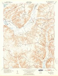 1951 Port Tobacco1953 Print · USGSSouthern Maryland's rural landscape is captured here in the early fifties, documenting the crossroads and creek-side settlements of Charles County. Genealogists and historians can trace family landmarks like the Thomas Stone Cem, Haber de Venture, and the St Joseph Ch Cem near Port Tobacco.2 unique versions available
 - 1956 Map of La Plata, 1958 Print
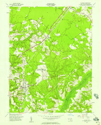 1956 La Plata1958 Print · USGSCharles County was undergoing steady development in the mid-fifties as the rail lines and highways connected rural crossroads. Researchers can trace family sites near La Plata, the Archbishop Neale Sch, and the unique Army Radio Receiving Station.5 unique versions available
 - 1956 Map of Port Tobacco, 1959 Print
 1956 Port Tobacco1959 Print · USGSMid-century Charles County is shown here during a period of rural stability and emerging infrastructure along the Potomac River. Genealogists and historians can trace family estates like Haber de Venture, visit the Mt Carmel Monastery, or follow the path of the Government Railroad.
 - 1956 Map of Indian Head, 1961 Print
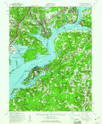 1956 Indian Head1961 Print · USGSThe Potomac shoreline in the mid-fifties is a landscape of federal reservations and tobacco-country heritage. Researchers can trace historic river landings like Proctors Wharf and significant sites such as the Indian Head Powder Factory or the Habre de Venture estate.2 unique versions available
 - 1957 Map of Washington, 1966 Print
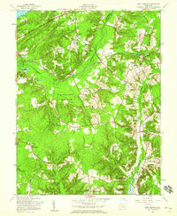
 1957 Washington1966 Print · USGSThe mid-Atlantic region during the mid-fifties and early sixties reveals a landscape of growing suburbs and vital military outposts. Researchers can trace historic river towns and shorelines from Alexandria to the Hooper Islands and St Clements Island.5 unique versions available
End of results
Showing maps 1-5 of 5
Top cities near La Plata
- Waldorf historical maps
- Fort Washington historical maps
- Woodlawn historical maps
- Lorton historical maps
- Fort Hunt historical maps
- Hybla Valley historical maps
See more
Top neighborhoods of La Plata
- Clarks Run historical maps
- Hickory Ridge historical maps
- Kent Square historical maps
- Kings Grant historical maps
- Maxwelton historical maps
- Old Colony historical maps
See more
Frequently asked questions
- What are the different types of historical maps available for La Plata?
- What is the oldest map of La Plata?
- Where can I purchase historical maps of La Plata for my home or office?
- Where can I download high-res historical maps of La Plata?
- Are there historical topographic maps available for La Plata?
- Is there historical aerial imagery available for La Plata?
- Where are historical maps of La Plata sourced from?