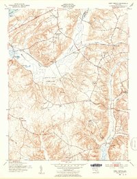
1951 Map of Port Tobacco
USGS Topo · Published 1953About this map
Haber de Venture, the home of Declaration of Independence signer Thomas Stone, stands as a focal point of this Southern Maryland landscape. Near the confluence of Port Tobacco Creek and Hoghole Run, the village of Port Tobacco reflects its deep colonial roots, while the nearby Thomas Stone Cem provides a specific link to the area's genealogical history. The interior is defined by the winding course of Mattawoman Creek and the expansive Myrtle Grove Game Farm.
Find a feature on this map
40 named features on this map. Tap any name to fly to it.
Don’t see what you’re looking for? This feature index may not catch every label — zoom into the map to look around manually.
Map Details
Editions of this 1951 Port Tobacco Map
2 editions found
Other maps of this area

1889 · Fredericksburg
USGS Topo · 1:125,000

1890 · Mt. Vernon
USGS Topo · 1:125,000

1891 · Mt. Vernon
USGS Topo · 1:125,000

1892 · Fredericksburg
USGS Topo · 1:125,000

1892 · Brandywine
USGS Topo · 1:62,500

1894 · Wicomico
USGS Topo · 1:62,500

1894 · Fredericksburg
USGS Topo · 1:125,000

1894 · Mt. Vernon
USGS Topo · 1:125,000

1895 · Wicomico
USGS Topo · 1:62,500

1895 · Brandywine
USGS Topo · 1:62,500