Old Maps of Lakesville, Maryland for Academic Research
Study the evolution of Lakesville with 16 high-resolution historic maps. Whether you're teaching, researching, or modeling changes in land use, these maps provide essential visual documentation of urban, environmental, and geographic change.
- Analyze long-term change: Track patterns in development, transportation, and natural features.
- Ideal for environmental or urban studies: Support academic projects with primary historical map data.
- Use in the classroom or lab: Educators and researchers rely on these maps to bring historical context to life.
These maps are a powerful tool for teaching, research, and visualizing how Lakesville has changed over the decades.
Lakesville, MD maps
(16)- 1898 Map of St. Marys
 1898 St. Marys1898 Print · USGSMaryland's tidewater region is captured here in the late nineteenth century, showing the intricate geography of the lower Chesapeake. Genealogists can trace family roots through old landings and villages like Great Mills, Toddville, and Solomons.2 unique versions available
 - 1905 Map of Crapo
 1905 Crapo1905 Print · USGSDorchester County at the turn of the century is a landscape of tide-water landings and island villages. Genealogists can trace family roots in Lakesville, Bucktown, and Hoopersville, or locate early maritime sites like Shorters Landing and the Steamboat Route.3 unique versions available
 - 1906 Map of St. Marys
 1906 St. Marys1906 Print · USGSChesapeake Bay and the Potomac River converge in this 1906 survey of the Maryland and Virginia tidewater. Historians can trace the region's maritime heritage through dozens of named landings and islands, from Solomons Id. to the remote reaches of Smith Island.4 unique versions available
 - 1942 Map of Honga, 1958 Print
 1942 Honga1958 Print · USGSDorchester County’s water-bound communities come alive in this wartime-era survey of the Eastern Shore. Genealogists and historians can trace the foundations of Hoopersville and Crapo, or locate forgotten docks like CARROLS LDG and the HOOPER ISLAND PIER.3 unique versions available
 - 1943 Map of Honga
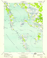
 1943 Honga1943 Print · USGSChesapeake Bay island life is preserved on this mid-century survey of Dorchester County, Maryland. Genealogists and historians can trace family-named landings and points from Hoopersville to Lakesville, including the Cannery and Carrols Ldg.
 - 1948 Map of Washington
 1948 Washington1948 Print · USGSThe Potomac and Chesapeake regions in the late 1940s reveal a landscape of expanding military reach and deep-rooted Tidewater settlements. Trace old rail corridors like the Richmond Fredericksburg & Potomac RR or locate landmarks like the Wakefield Washington Monument and St. Marys College.2 unique versions available
 - 1957 Map of Washington, 1966 Print
 1957 Washington1966 Print · USGSThe mid-Atlantic region during the mid-fifties and early sixties reveals a landscape of growing suburbs and vital military outposts. Researchers can trace historic river towns and shorelines from Alexandria to the Hooper Islands and St Clements Island.5 unique versions available
 - 1961 Map of Washington
 1961 Washington1961 Print · USGSThe mid-Atlantic region in the late fifties is presented in remarkable detail, from the Blue Ridge foothills to the Chesapeake Eastern Shore. Researchers can trace historic river landings and military sites like Mount Vernon, Fort Belvoir, and Point Lookout.2 unique versions available
 - 1983 Map of Leonardtown, 1984 Print
 1983 Leonardtown1984 Print · USGSSouthern Maryland and the Northern Neck of Virginia are shown in the early eighties as a mosaic of historic tidewater settlements and modern installations. Trace family roots and shoreline changes near St Marys City, Leonardtown, and Colonial Beach.2 unique versions available
 - 1984 Map of Honga
 1984 Honga1984 Print · USGSDorchester County's marshy estuaries and islands appear in detail in this mid-eighties survey. Genealogists and historians can trace the water-bound communities of Hoopersville and Lakesville, or locate landmarks like Hoopers Mem Church and The Canal.
 - 1989 Map of Washington
 1989 Washington1989 Print · USGSThe Potomac River valley and Chesapeake Bay are shown in comprehensive detail during the late 1980s. Genealogists and historians can trace the transition from urban Alexandria to the rural Northern Neck, locating landmarks like Mount Vernon and Stratford Hall.
 - 2011 Map of Honga, 2011 Print
 2011 Honga2011 Print · USGSCovers Lakesville, including Crapo, Hooper Islands, and other nearby areas
 - 2014 Map of Honga, 2014 Print
 2014 Honga2014 Print · USGSCovers Lakesville, including Crapo, Hooper Islands, and other nearby areas
 - 2016 Map of Honga, 2016 Print
 2016 Honga2016 Print · USGSCovers Lakesville, including Crapo, Hooper Islands, and other nearby areas
 - 2019 Map of Honga, 2019 Print
 2019 Honga2019 Print · USGSCovers Lakesville, including Crapo, Hooper Islands, and other nearby areas
 - 2023 Map of Honga, 2023 Print
 2023 Honga2023 Print · USGSDorchester County's tidal landscape is captured here in the early twenty-first century, showing the fragile connection between island and mainland. Researchers can trace the narrow settlements of Honga and Fishing Creek or find family landmarks along Steamboat Wharf Rd.
End of results
Showing maps 1-16 of 16
Top cities near Lakesville
Frequently asked questions
- What are the different types of historical maps available for Lakesville?
- What is the oldest map of Lakesville?
- Where can I purchase historical maps of Lakesville for my home or office?
- Where can I download high-res historical maps of Lakesville?
- Are there historical topographic maps available for Lakesville?
- Is there historical aerial imagery available for Lakesville?
- Where are historical maps of Lakesville sourced from?