1940s Maps of McPherson, Maryland
Explore 3 historic maps of McPherson from the 1940s. These maps offer a rare glimpse into what life looked like during the 1940s — showing old roads, neighborhoods, homes, and landmarks that have changed or disappeared over time.
Whether you're researching your family's past, planning a metal detecting trip, or studying how McPherson's landscape evolved across the 1940s, these high-resolution maps are a powerful tool for exploring the history of this region.
- Focus on a specific era: All maps on this page are from the 1940s, giving you a focused view of this time period.
- See what’s changed: Compare century-old streets, trails, and buildings to today's modern landscape using overlays and satellite layers.
- Research with precision: Use these maps for genealogy, historical research, land use analysis, or educational projects.
- View, download, or print: Maps are fully viewable online in high resolution, and can be downloaded or printed for your own records.
Start exploring McPherson's history through authentic maps from the 1940s. This is your window into the past.
McPherson, MD maps
(3)- 1944 Map of Libertytown, 1970 Print
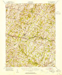
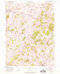 1944 Libertytown1970 Print · USGSMaryland's rolling countryside during the mid-forties is captured here, showing the rural crossroads and farming communities of Frederick and Carroll Counties. Researchers can locate family landmarks such as Ridge Sch No 4, the Lime Mill, and the rail stops of the Baltimore and Ohio.4 unique versions available
 - 1945 Map of Mount Airy, 1955 Print
 1945 Mount Airy1955 Print · USGSMid-century central Maryland is captured here as a landscape of rural villages and crossroads just before post-war expansion. Genealogists and historians can trace family locations through Mount Airy, Libertytown, and Damascus, or follow the Baltimore and Ohio rail line.2 unique versions available
 - 1948 Map of Baltimore
 1948 Baltimore1948 Print · USGSMaryland and Pennsylvania crossroads are captured in the late 1940s, showing a landscape defined by historic rail lines and major military installations. Genealogists can trace family connections in Gettysburg, Westminster, and near the U.S. Naval Academy in Annapolis.2 unique versions available
End of results
Showing maps 1-3 of 3
Top cities near McPherson
- Germantown historical maps
- Frederick historical maps
- Westminster historical maps
- Clarksburg historical maps
- Damascus historical maps
- Dayton historical maps
See more
Frequently asked questions
- What are the different types of historical maps available for McPherson?
- What is the oldest map of McPherson?
- Where can I purchase historical maps of McPherson for my home or office?
- Where can I download high-res historical maps of McPherson?
- Are there historical topographic maps available for McPherson?
- Is there historical aerial imagery available for McPherson?
- Where are historical maps of McPherson sourced from?