1950s Maps of Rock Hall, Maryland
Explore 6 historic maps of Rock Hall from the 1950s. These maps offer a rare glimpse into what life looked like during the 1950s — showing old roads, neighborhoods, homes, and landmarks that have changed or disappeared over time.
Whether you're researching your family's past, planning a metal detecting trip, or studying how Rock Hall's landscape evolved across the 1950s, these high-resolution maps are a powerful tool for exploring the history of this region.
- Focus on a specific era: All maps on this page are from the 1950s, giving you a focused view of this time period.
- See what’s changed: Compare century-old streets, trails, and buildings to today's modern landscape using overlays and satellite layers.
- Research with precision: Use these maps for genealogy, historical research, land use analysis, or educational projects.
- View, download, or print: Maps are fully viewable online in high resolution, and can be downloaded or printed for your own records.
Start exploring Rock Hall's history through authentic maps from the 1950s. This is your window into the past.
Rock Hall, MD maps
(6)- 1951 Map of Chestertown
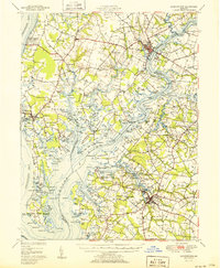 1951 Chestertown1951 Print · USGSThe Chesapeake Bay shoreline and Chester River necks appear in high detail during the early fifties. Genealogists and historians can trace family locations through numerous country landmarks like Wesley Chapel Cem, Starkey Corner, and Tolchester Beach.2 unique versions available
 - 1953 Map of Rock Hall, 1955 Print
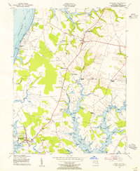 1953 Rock Hall1955 Print · USGSMaryland's Eastern Shore in the mid-fifties is captured here, showing the waterfront communities and landings of Kent County. Genealogists can trace early landmarks and burial sites like Wesley Chapel Cem, Tolchester Beach, and the settlement at Fairlee.3 unique versions available
 - 1953 Map of Swan Point, 1955 Print
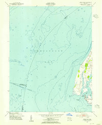 1953 Swan Point1955 Print · USGSThe Kent County shoreline and Chesapeake Bay waters are captured here in the early fifties, documenting the Eastern Shore's maritime character. Trace local history through detailed landings and waterfront settlements like Rock Hall, Gratitude, and Deep Landing.2 unique versions available
 - 1954 Map of Baltimore
 1954 Baltimore1954 Print · USGSThe Mid-Atlantic region in the early fifties shows a landscape of growing suburban centers and heavy rail corridors. Trace mid-century transit networks and military landmarks from the Aberdeen Proving Ground to the Gettysburg National Military Park.
 - 1956 Map of Baltimore
 1956 Baltimore1956 Print · USGSMid-century Maryland and Pennsylvania are captured here during a period of massive suburban and military growth across the Chesapeake region. Genealogists and historians can trace the rail corridors of the Baltimore & Ohio RR and locate landmarks like Fort McHenry or the Aberdeen Proving Ground.
 - 1957 Map of Baltimore, 1964 Print
 1957 Baltimore1964 Print · USGSMaryland and Southern Pennsylvania are shown during the mid-century expansion of the Baltimore-Washington corridor. Researchers can trace the extensive rail lines of the Baltimore & Ohio RR and locate sites like Fort Detrick and Gettysburg National Military Park.5 unique versions available
End of results
Showing maps 1-6 of 6
Top cities near Rock Hall
- Annapolis historical maps
- Middle River historical maps
- Cape Saint Claire historical maps
- Stevensville historical maps
- Chestertown historical maps
- Centreville historical maps
See more
Top neighborhoods of Rock Hall
Frequently asked questions
- What are the different types of historical maps available for Rock Hall?
- What is the oldest map of Rock Hall?
- Where can I purchase historical maps of Rock Hall for my home or office?
- Where can I download high-res historical maps of Rock Hall?
- Are there historical topographic maps available for Rock Hall?
- Is there historical aerial imagery available for Rock Hall?
- Where are historical maps of Rock Hall sourced from?