1940s Maps of Crisfield, Maryland
Explore 7 historic maps of Crisfield from the 1940s. These maps offer a rare glimpse into what life looked like during the 1940s — showing old roads, neighborhoods, homes, and landmarks that have changed or disappeared over time.
Whether you're researching your family's past, planning a metal detecting trip, or studying how Crisfield's landscape evolved across the 1940s, these high-resolution maps are a powerful tool for exploring the history of this region.
- Focus on a specific era: All maps on this page are from the 1940s, giving you a focused view of this time period.
- See what’s changed: Compare century-old streets, trails, and buildings to today's modern landscape using overlays and satellite layers.
- Research with precision: Use these maps for genealogy, historical research, land use analysis, or educational projects.
- View, download, or print: Maps are fully viewable online in high resolution, and can be downloaded or printed for your own records.
Start exploring Crisfield's history through authentic maps from the 1940s. This is your window into the past.
Crisfield, MD maps
(7)- 1942 Map of Marion, 1958 Print
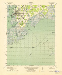
 1942 Marion1958 Print · USGSSomerset County's coastal reaches are documented here during the early war years, highlighting the intricate marshlands and rail-dependent villages. Genealogists can locate family landmarks like Samuel Webster Ch or trace the old rail stops at Marion and Hopewell.2 unique versions available
 - 1943 Map of Crisfield
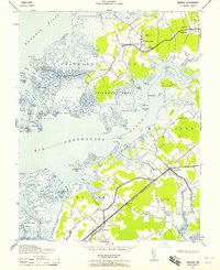
 1943 Crisfield1943 Print · USGSThe seafood capital of the Chesapeake comes to life in the 1940s, showcasing the intricate waterfront and rail infrastructure of Somerset County. Genealogists can trace families in Sackertown and Birdtown or locate the Indian Hammock cemetery.
 - 1943 Map of Marion
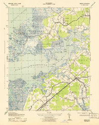 1943 Marion1943 Print · USGSSomerset County's Eastern Shore is captured here in the early 1940s, showing a landscape of tidal marshes and rail-linked villages. Genealogists can locate family-named points and rural congregations like Wayman Church or trace the old Pennsylvania Railroad line near Marion.
 - 1946 Map of Salisbury, 1948 Print
 1946 Salisbury1948 Print · USGSThe Delmarva Peninsula in the late nineteen-forties shows a landscape defined by its deep river arteries and emerging coastal defenses. Genealogists and historians can trace rail-connected towns like Federalsburg or locate maritime landmarks such as the Ocean City Seaplane Base and Fort Miles Military Reservation.4 unique versions available
 - 1946 Map of Eastville, 1971 Print
 1946 Eastville1971 Print · USGSCoastal Virginia and the Outer Banks are captured here during a period of expanding naval and aerospace presence. Researchers can trace the path of the Penn Central railroad through Chincoteague and Modest Town, or locate landmarks like the Wright Brothers National Memorial.
 - 1947 Map of Salisbury, 1948 Print
 1947 Salisbury1948 Print · USGSThe Delmarva Peninsula in the late forties reveals a coastal landscape of maritime defense and growing seaside towns. Trace the post-war footprint of Salisbury, the strategic Fort Miles Military Reservation, and the Ocean City Seaplane Base.
 - 1948 Map of Salisbury, 1951 Print
 1948 Salisbury1951 Print · USGSThe Delmarva Peninsula in the late 1940s is shown here as a busy network of rail-towns and coastal outposts. Researchers can trace the legacy of the Pennsylvania Railroad through inland hubs like Georgetown or the maritime reaches of Crisfield and Cape May.
End of results
Showing maps 1-7 of 7
Top cities near Crisfield
- Princess Anne historical maps
- Parksley historical maps
- Tangier historical maps
- Bloxom historical maps
- Chase Crossing historical maps
- Whitesville historical maps
See more
Top neighborhoods of Crisfield
Frequently asked questions
- What are the different types of historical maps available for Crisfield?
- What is the oldest map of Crisfield?
- Where can I purchase historical maps of Crisfield for my home or office?
- Where can I download high-res historical maps of Crisfield?
- Are there historical topographic maps available for Crisfield?
- Is there historical aerial imagery available for Crisfield?
- Where are historical maps of Crisfield sourced from?