1960s Maps of Crisfield, Maryland
Explore 5 historic maps of Crisfield from the 1960s. These maps offer a rare glimpse into what life looked like during the 1960s — showing old roads, neighborhoods, homes, and landmarks that have changed or disappeared over time.
Whether you're researching your family's past, planning a metal detecting trip, or studying how Crisfield's landscape evolved across the 1960s, these high-resolution maps are a powerful tool for exploring the history of this region.
- Focus on a specific era: All maps on this page are from the 1960s, giving you a focused view of this time period.
- See what’s changed: Compare century-old streets, trails, and buildings to today's modern landscape using overlays and satellite layers.
- Research with precision: Use these maps for genealogy, historical research, land use analysis, or educational projects.
- View, download, or print: Maps are fully viewable online in high resolution, and can be downloaded or printed for your own records.
Start exploring Crisfield's history through authentic maps from the 1960s. This is your window into the past.
Crisfield, MD maps
(5)- 1961 Map of Eastville
 1961 Eastville1961 Print · USGSThe Eastern Shore and Outer Banks are captured here in the mid-twentieth century, showing a maritime landscape of lighthouses, rail-linked towns, and naval outposts. Researchers can trace the Pennsylvania Railroad through Parksley or locate historical sites like Chincoteague Field Naval Auxiliary Air Station and Tangier Island.
 - 1961 Map of Salisbury
 1961 Salisbury1961 Print · USGSThe Delmarva Peninsula comes into focus in the early sixties, showing the vital road and rail networks connecting the Chesapeake to the Atlantic. Genealogists and historians can trace family-named landings and coastal landmarks from Crisfield to the Brandywine Shoal Lighthouse.
 - 1965 Map of Salisbury
 1965 Salisbury1965 Print · USGSThe Delmarva Peninsula in the mid-1960s is depicted here as a landscape of coastal defenses and maritime hubs. Genealogists and local historians can trace the foundations of bayside towns like Crisfield and the tactical positioning of the Fort Miles Military Reservation and Cape May Naval Air Station.
 - 1966 Map of Eastville
 1966 Eastville1966 Print · USGSThe Delmarva Peninsula and Outer Banks appear in the mid-sixties, showing a landscape of maritime trade, military outposts, and fishing villages. Researchers can trace the lines of the Norfolk & Southern through Exmore and Parksley or locate historical sites like Fort John Custis and the Janes Island Lighthouse.
 - 1968 Map of Crisfield, 1972 Print
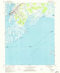 1968 Crisfield1972 Print · USGSCoastal Somerset County comes alive in this late-sixties survey of the area's intricate marshlands and seafood-processing centers. Genealogists and local historians can trace family-named settlements like Sackertown, Byrdtown, and Mariners or locate local institutions like Phoenix Ch.5 unique versions available
End of results
Showing maps 1-5 of 5
Top cities near Crisfield
- Princess Anne historical maps
- Parksley historical maps
- Tangier historical maps
- Bloxom historical maps
- Chase Crossing historical maps
- Whitesville historical maps
See more
Top neighborhoods of Crisfield
Frequently asked questions
- What are the different types of historical maps available for Crisfield?
- What is the oldest map of Crisfield?
- Where can I purchase historical maps of Crisfield for my home or office?
- Where can I download high-res historical maps of Crisfield?
- Are there historical topographic maps available for Crisfield?
- Is there historical aerial imagery available for Crisfield?
- Where are historical maps of Crisfield sourced from?