Old Maps of Sandwich, Massachusetts for Genealogy
Trace your family roots with 66 historic maps of Sandwich. These high-res maps reveal old neighborhoods, homesites, landmarks, and streets — helping you uncover where your ancestors lived and how the area evolved over time.
- Explore historic neighborhoods: Identify where your relatives may have lived in the 1800s or 1900s.
- Compare maps over time: Trace the changes in streets, buildings, and landmarks for multi-generational research.
- Perfect for genealogy & ancestry research: Used by family historians and researchers to map out lineage and migration.
These maps are an incredible resource for exploring your personal connection to Sandwich's past.
Sandwich, MA maps
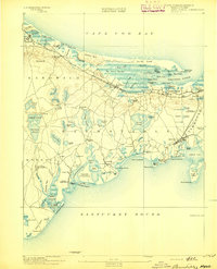
(66)- 1886 Map of Falmouth
 1886 Falmouth1886 Print · USGSThe Cape Cod peninsula during the late nineteenth century shows a landscape transitioning between maritime tradition and rail-driven growth. Genealogists can trace family footprints in Waquoit Village, Teaticket, and Menauhant while following the Old Colony Railroad corridor.
 - 1886 Map of Plymouth
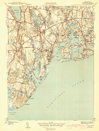
 1886 Plymouth1886 Print · USGSThe South Shore and Cape Cod gateway appear here at a moment of transition during the late nineteenth century. Trace family roots and old rail lines through Chiltonville and Manomet, or follow the early footprint of the Cape Cod Canal.
 - 1888 Map of Barnstable
 1888 Barnstable1888 Print · USGSMid-Cape Cod in the late nineteenth century was defined by its maritime commerce and the arrival of the rail. Genealogists and historians can trace the foundations of local life at the Indian Meeting House, Marston's Mills, and the Old Colony Railroad.
 - 1888 Map of Falmouth
 1888 Falmouth1888 Print · USGSThe Buzzards Bay coastline and upper Cape Cod are captured here in the late nineteenth century, documenting the critical arrival of the railroad. Researchers can trace the Old Colony Railroad to its terminus at Woods Holl or locate maritime landmarks like Wing's Neck Light.
 - 1889 Map of Plymouth
 1889 Plymouth1889 Print · USGSCoastal Massachusetts at the close of the nineteenth century reveals a landscape of maritime trade and emerging rail corridors. Trace the historic routes of the Old Colony Railroad South Shore Branch and identify early settlement patterns in Plymouth, Chiltonville, and Wareham Centre.
 - 1893 Map of Barnstable
 1893 Barnstable1893 Print · USGSCape Cod in the late nineteenth century remains a landscape of maritime navigation and early rail travel. Genealogists can trace family roots through sites like the Indian Meeting House, the Yarmouth Camp Grounds, and the Spring Hill Academy.8 unique versions available
 - 1893 Map of Falmouth
 1893 Falmouth1893 Print · USGSCape Cod's western shore and the upper reaches of Buzzards Bay are captured here in the late nineteenth century as rail travel transformed the coast. Genealogists can trace family names at Waquoit Village or follow the Old Colony Railroad through Woods Holl and Falmouth Station.9 unique versions available
 - 1894 Map of Plymouth
 1894 Plymouth1894 Print · USGSCoastal Massachusetts at the end of the nineteenth century reveals a landscape of maritime commerce and kettle ponds. Trace the rail lines of the Old Colony Railroad and find early village sites like Wellingsly, Chiltonville, and Bournedale.9 unique versions available
 - 1915 Map of Falmouth, 1943 Print
 1915 Falmouth1943 Print · USGSUpper Cape Cod during the mid-forties reveals a landscape of growing military activity alongside traditional coastal villages. Genealogists and historians can trace the foundations of Camp Edwards and find historic post offices at Waquoit Village or Monument Beach.
 - 1920 Map of Falmouth
 1920 Falmouth1920 Print · USGSCoastal Barnstable County comes to life in this post-war military survey of the Falmouth peninsula and its maritime approaches. Researchers can trace the Old Colony RR to Falmouth Station or locate landmarks like Nobska Point Light and Waquoit Village.
 - 1921 Map of Plymouth
 1921 Plymouth1921 Print · USGSThe Plymouth coast and its pond-strewn interior are shown in the early 1920s, featuring a dense network of maritime landmarks and rail lines. Genealogists can trace family names and locations near Chiltonville, White Horse Beach, and the Old Colony R.R. Plymouth Branch.
 - 1933 Map of Sagamore
 1933 Sagamore1933 Print · USGSThe Cape Cod shoreline and the recently completed canal define this area in the early 1930s. Researchers can trace the layout of coastal settlements like Sagamore Beach, locate the Indian Cem, and find industrial landmarks like Garland Bog.
 - 1935 Map of Pocasset
 1935 Pocasset1935 Print · USGSThe Upper Cape coast and its military transition are captured in the mid-1930s, showing the early layout of Camp Edwards. Trace the coastal rail line through Pocasset Sta or locate family landmarks like the Tobey Cem and the State Pier.
 - 1938 Map of Sandwich
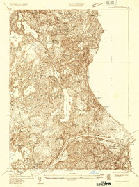
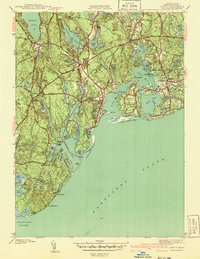
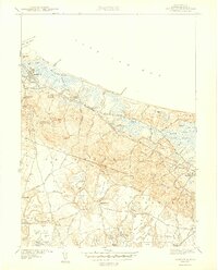
 1938 Sandwich1938 Print · USGSCape Cod's north shore and central pine barrens appear in detail during the late 1930s. Genealogists can locate family names at Tobey Cem and Percival Cem, or trace the rail corridor of the New York New Haven and Hartford.
 - 1939 Map of Sandwich
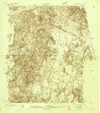
 1939 Sandwich1939 Print · USGSCape Cod's northern shore and the interior of Barnstable County appear here in the late 1930s, featuring a landscape of expansive salt marshes and numerous kettle ponds. Genealogists can locate family landmarks like Freeman Cem and the Old Quaker Meetinghouse or trace the early Cape Cod Airport.
 - 1940 Map of Sagamore
 1940 Sagamore1940 Print · USGSThe Cape Cod Canal area in the 1940s reveals a maritime landscape transitioning toward modern infrastructure. Trace family roots and local history through Sagamore village, the Indian Cem, and the rail lines of the New York New Haven and Hartford.4 unique versions available
 - 1940 Map of Sandwich
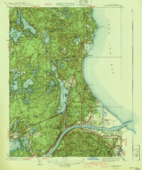
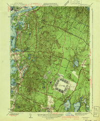
 1940 Sandwich1940 Print · USGSCape Cod’s oldest town and the surrounding marshes are captured just before the war as a landscape of rural villages and glacial ponds. Genealogy researchers can trace family landmarks like the Tobey Cem, the Old Quaker Meetinghouse, and the Cape Cod Airport.
 - 1941 Map of Cotuit
 1941 Cotuit1941 Print · USGSCape Cod's south shore and the villages of Barnstable appear here in the late thirties, before modern coastal development reshaped the peninsula. Researchers can trace ancestral sites like the Old Indian School, St Marys church, and family plots in Hillside Cem.2 unique versions available
 - 1941 Map of Pocasset
 1941 Pocasset1941 Print · USGSCape Cod was undergoing significant military expansion in the early 1940s while maintaining its seaside character. Researchers can trace the layout of Camp Edwards and Otis Field alongside coastal villages like Cataumet and Monument Beach.2 unique versions available
 - 1942 Map of Cape Cod Bay
 1942 Cape Cod Bay1942 Print · USGSThe mid-Cape and Outer Cape regions are shown here during the early war years, documenting a landscape of coastal villages and maritime trade. Researchers can trace family roots through old settlements like South Truro, find the grounds of Camp Edwards, or locate historic aids like Sandy Neck Light.
 - 1942 Map of New Bedford
 1942 New Bedford1942 Print · USGSSoutheastern Massachusetts at the start of the 1940s shows a region defined by maritime defense and industrial rail corridors. Genealogists and historians can trace the massive Camp Edwards boundary, old rail stops like Rock Station, and vanished local industry at Paper Mill Village.2 unique versions available
 - 1943 Map of Cotuit
 1943 Cotuit1943 Print · USGSCape Cod's south shore appears in the early forties as a landscape of interconnected bays and quiet villages before the post-war building boom. Genealogists and local historians can trace family plots in the Old Barnstable Cem or locate the historic school and church sites in Marstons Mills and Santuit.3 unique versions available
 - 1943 Map of Pocasset
 1943 Pocasset1943 Print · USGSCape Cod was undergoing a massive military transformation during the early forties, even as its traditional coastal villages remained intact. Researchers can trace the sprawling layout of Camp Edwards and Otis Field alongside local landmarks like Pocasset Sta and the Beaton Bog.2 unique versions available
 - 1943 Map of Sandwich
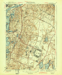
 1943 Sandwich1943 Print · USGSCape Cod's northern shore and interior kettle ponds are documented in the early 1940s, just as modern infrastructure began to shape the region. Genealogists can trace family roots at the Old Quaker Meetinghouse, Freeman Cem, and the historic village of Sandwich.5 unique versions available
 - 1943 Map of Plymouth
 1943 Plymouth1943 Print · USGSThe coastal stretch from Plymouth to the Cape Cod Canal shows its wartime character here, when rail travel still connected these maritime towns. Genealogists can trace early homesteads and landmarks near Billington Sea, Manomet, and the Old Colony Railroad corridor.
Showing maps 1-25 of 66
Top cities near Sandwich
- Plymouth historical maps
- Falmouth historical maps
- Yarmouth historical maps
- Wareham historical maps
- Hyannis historical maps
- Bourne historical maps
See more
Top neighborhoods of Sandwich
- Camp Edwards historical maps
- Farmersville historical maps
- Old Quaker Meetinghouse historical maps
- Scorton Shores historical maps
- Camp Burgess historical maps
- East Sandwich historical maps
See more
Frequently asked questions
- What are the different types of historical maps available for Sandwich?
- What is the oldest map of Sandwich?
- Where can I purchase historical maps of Sandwich for my home or office?
- Where can I download high-res historical maps of Sandwich?
- Are there historical topographic maps available for Sandwich?
- Is there historical aerial imagery available for Sandwich?
- Where are historical maps of Sandwich sourced from?