1800s (19th Century) Maps of Truro, Massachusetts
Explore 6 historic maps of Truro from the 1800s (19th Century). These maps offer a rare glimpse into what life looked like during the 1800s — showing old roads, neighborhoods, homes, and landmarks that have changed or disappeared over time.
Whether you're researching your family's past, planning a metal detecting trip, or studying how Truro's landscape evolved across the 1800s, these high-resolution maps are a powerful tool for exploring the history of this region.
- Focus on a specific era: All maps on this page are from the 1800s, giving you a focused view of this time period.
- See what’s changed: Compare century-old streets, trails, and buildings to today's modern landscape using overlays and satellite layers.
- Research with precision: Use these maps for genealogy, historical research, land use analysis, or educational projects.
- View, download, or print: Maps are fully viewable online in high resolution, and can be downloaded or printed for your own records.
Start exploring Truro's history through authentic maps from the 1800s. This is your window into the past.
Truro, MA maps
(6)- 1887 Map of Wellfleet
 1887 Wellfleet1887 Print · USGSThe lower Cape comes into focus during the late nineteenth and early twentieth centuries as the railroad reshapes coastal commerce. Genealogists and historians can trace family locations near the Methodist Camp Ground, Mayo's Beach Light, and the Marconi Towers.
 - 1887 Map of Provincetown
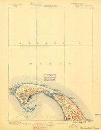
 1887 Provincetown1887 Print · USGSThe outer hook of Cape Cod appears here during the height of its maritime importance, featuring a critical network of lighthouses and life-saving stations. Genealogists and maritime historians can trace the early layout of Provincetown, the remote reaches of North Truro, and landmarks like Cape Cod Light.
 - 1889 Map of Provincetown
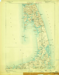
 1889 Provincetown1889 Print · USGSThe tip of Cape Cod is captured in the late nineteenth century as a critical maritime hub and life-saving corridor. Trace the early streets of Provincetown, the isolated Highland Light, and the vital Race Point Life Saving Station along the Atlantic shore.7 unique versions available
 - 1889 Map of Wellfleet
 1889 Wellfleet1889 Print · USGSThe Lower Cape is shown here in the late nineteenth century as a vital maritime and railroad corridor. Genealogists and historians can trace the early rail stops and shoreline landmarks like the Methodist Camp Ground and the Billingsgate Light.
 - 1893 Map of Wellfleet
 1893 Wellfleet1893 Print · USGSCape Cod's outer reaches are shown in the late 1800s, when the Old Colony Railroad served isolated fishing villages and lifesaving stations. Trace historic sites like the Methodist Camp Ground, Billingsgate Light, and early schools at Schoolhouse Pond.8 unique versions available
 - 1898 Map of Provincetown, 1940 Print
 1898 Provincetown1940 Print · USGSCoastal Massachusetts in the late nineteenth century comes to life through this detailed look at the outer Cape. Genealogists and maritime historians can trace a network of early federal outposts like Highland Life Saving Station and beacons such as Long Point Light.
End of results
Showing maps 1-6 of 6
Top cities near Truro
- Dennis historical maps
- Brewster historical maps
- Orleans historical maps
- Eastham historical maps
- Provincetown historical maps
- Wellfleet historical maps
Top neighborhoods of Truro
- Pond Village historical maps
- North Truro historical maps
- Pilgrim Heights historical maps
- Beach Point historical maps
- South Truro historical maps
Frequently asked questions
- What are the different types of historical maps available for Truro?
- What is the oldest map of Truro?
- Where can I purchase historical maps of Truro for my home or office?
- Where can I download high-res historical maps of Truro?
- Are there historical topographic maps available for Truro?
- Is there historical aerial imagery available for Truro?
- Where are historical maps of Truro sourced from?