1940s Maps of Truro, Massachusetts
Explore 9 historic maps of Truro from the 1940s. These maps offer a rare glimpse into what life looked like during the 1940s — showing old roads, neighborhoods, homes, and landmarks that have changed or disappeared over time.
Whether you're researching your family's past, planning a metal detecting trip, or studying how Truro's landscape evolved across the 1940s, these high-resolution maps are a powerful tool for exploring the history of this region.
- Focus on a specific era: All maps on this page are from the 1940s, giving you a focused view of this time period.
- See what’s changed: Compare century-old streets, trails, and buildings to today's modern landscape using overlays and satellite layers.
- Research with precision: Use these maps for genealogy, historical research, land use analysis, or educational projects.
- View, download, or print: Maps are fully viewable online in high resolution, and can be downloaded or printed for your own records.
Start exploring Truro's history through authentic maps from the 1940s. This is your window into the past.
Truro, MA maps
(9)- 1942 Map of Cape Cod Bay
 1942 Cape Cod Bay1942 Print · USGSThe mid-Cape and Outer Cape regions are shown here during the early war years, documenting a landscape of coastal villages and maritime trade. Researchers can trace family roots through old settlements like South Truro, find the grounds of Camp Edwards, or locate historic aids like Sandy Neck Light.
 - 1942 Map of Nauset, 1943 Print
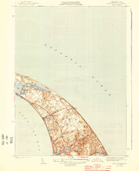
 1942 Nauset1943 Print · USGSLower Cape Cod and its maritime frontier are captured here during the early Forties, showing the vital coastal infrastructure of the era. Genealogists and historians can trace family locations and landmarks from South Wellfleet to Chatham, including Nauset Beach Light and several Life Saving Stations.
 - 1944 Map of Provincetown
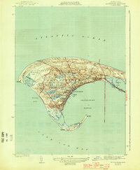 1944 Provincetown1944 Print · USGSCape Cod's outer tip shows its mid-century maritime character and infrastructure just before post-war tourism transformed the landscape. Researchers can trace the original rail lines of the New Haven and Hartford and locate historic markers like the Pilgrim Monument and Race Point Lighthouse.3 unique versions available
 - 1944 Map of Wellfleet
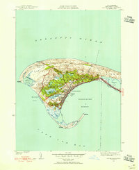
 1944 Wellfleet1944 Print · USGSThe outer Cape in the early 1940s is captured here in fine detail, from the rail stop at Truro Sta to the shifting sands of Wellfleet Harbor. Researchers can trace old family lineages through Pleasant Hill Cem or locate vanished sites like Billingsgate Island.5 unique versions available
 - 1944 Map of North Truro
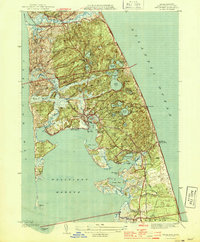
 1944 North Truro1944 Print · USGSThe Outer Cape's fragile coastline is meticulously detailed in the early 1940s, showing the narrow land between Cape Cod Bay and the ocean. Researchers can trace historical footprints at the Old North Cem and the iconic Cape Cod Lighthouse.4 unique versions available
 - 1947 Map of Providence, 1948 Print
 1947 Providence1948 Print · USGSSouthern New England is captured in the mid-1940s, showing a landscape defined by busy industrial ports and expanding military installations. Researchers can trace the rail lines of the N.Y. N.H. & H. RR or locate coastal defenses like Fort Adams and Quonset Point.5 unique versions available
 - 1948 Map of Boston
 1948 Boston1948 Print · USGSEastern Massachusetts and southern New Hampshire appear at an industrial peak in the late 1940s, just as suburban growth began to accelerate. Genealogists and historians can trace rail lines like the Boston and Albany RR or locate coastal landmarks like Graves Lighthouse and Fort Devens.2 unique versions available
 - 1948 Map of Providence, 1951 Print
 1948 Providence1951 Print · USGSSouthern New England’s coastal reaches are captured here in the late 1940s, from the industrial heart of Providence to the tip of Provincetown. Genealogists and historians can trace rail lines like the Central Vermont Railway and locate active military sites such as Otis Air Force Base and Fort Rodman.
 - 1949 Map of Provincetown, 1955 Print
 1949 Provincetown1955 Print · USGSProvincetown and the tip of Cape Cod are captured here in the decade following World War II, showing the town's evolution from a fishing port to a coastal hub. Researchers can trace the old New York New Haven and Hartford rail line, the iconic Pilgrim Monument, and coastal landmarks like Long Point Lighthouse.2 unique versions available
End of results
Showing maps 1-9 of 9
Top cities near Truro
- Dennis historical maps
- Brewster historical maps
- Orleans historical maps
- Eastham historical maps
- Provincetown historical maps
- Wellfleet historical maps
Top neighborhoods of Truro
- Pond Village historical maps
- North Truro historical maps
- Pilgrim Heights historical maps
- Beach Point historical maps
- South Truro historical maps
Frequently asked questions
- What are the different types of historical maps available for Truro?
- What is the oldest map of Truro?
- Where can I purchase historical maps of Truro for my home or office?
- Where can I download high-res historical maps of Truro?
- Are there historical topographic maps available for Truro?
- Is there historical aerial imagery available for Truro?
- Where are historical maps of Truro sourced from?