1970s Maps of Algerie Four Corners, Otis
Explore 2 historic maps of Algerie Four Corners from the 1970s. These maps offer a rare glimpse into what life looked like during the 1970s — showing old roads, neighborhoods, homes, and landmarks that have changed or disappeared over time.
Whether you're researching your family's past, planning a metal detecting trip, or studying how Algerie Four Corners's landscape evolved across the 1970s, these high-resolution maps are a powerful tool for exploring the history of this region.
- Focus on a specific era: All maps on this page are from the 1970s, giving you a focused view of this time period.
- See what’s changed: Compare century-old streets, trails, and buildings to today's modern landscape using overlays and satellite layers.
- Research with precision: Use these maps for genealogy, historical research, land use analysis, or educational projects.
- View, download, or print: Maps are fully viewable online in high resolution, and can be downloaded or printed for your own records.
Start exploring Algerie Four Corners's history through authentic maps from the 1970s. This is your window into the past.
Algerie Four Corners, Otis maps
(2)- 1973 Map of Otis, 1974 Print
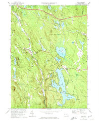 1973 Otis1974 Print · USGSThe southern Berkshire hills in the early 1970s show a landscape of expansive state forests and growing recreational hubs like the Otis Reservoir. Researchers can trace old transportation routes including an Old Railroad Grade or find family history at West Center Cem and Beech Plain Cem.2 unique versions available
 - 1975 Map of Otis, 1981 Print
 1975 Otis1981 Print · USGSThe Berkshire hills are captured in the mid-seventies through this aerial survey, showcasing a landscape of dense forests and large water bodies. Genealogists and researchers can trace the roads connecting Otis, East Otis, and Algerie Four Corners near the expansive Otis Reservoir.
End of results
Showing maps 1-2 of 2
Top cities near Algerie Four Corners
- Pittsfield historical maps
- Westfield historical maps
- Granby historical maps
- Southwick historical maps
- Great Barrington historical maps
- Dalton historical maps
See more
Frequently asked questions
- What are the different types of historical maps available for Algerie Four Corners?
- What is the oldest map of Algerie Four Corners?
- Where can I purchase historical maps of Algerie Four Corners for my home or office?
- Where can I download high-res historical maps of Algerie Four Corners?
- Are there historical topographic maps available for Algerie Four Corners?
- Is there historical aerial imagery available for Algerie Four Corners?
- Where are historical maps of Algerie Four Corners sourced from?