Old Maps of Algerie Four Corners, Otis for Academic Research
Study the evolution of Algerie Four Corners with 25 high-resolution historic maps. Whether you're teaching, researching, or modeling changes in land use, these maps provide essential visual documentation of urban, environmental, and geographic change.
- Analyze long-term change: Track patterns in development, transportation, and natural features.
- Ideal for environmental or urban studies: Support academic projects with primary historical map data.
- Use in the classroom or lab: Educators and researchers rely on these maps to bring historical context to life.
These maps are a powerful tool for teaching, research, and visualizing how Algerie Four Corners has changed over the decades.
Algerie Four Corners, Otis maps
(25)- 1888 Map of Sandisfield
 1888 Sandisfield1888 Print · USGSThe Berkshires at the end of the nineteenth century reveal a landscape of mountain villages and river-powered industry. Genealogists can trace family roots through the early roads of Sandisfield, New Marlborough, and the banks of the Farmington River.
 - 1893 Map of Sandisfield
 1893 Sandisfield1893 Print · USGSThe Berkshires and northern Litchfield County are captured here in the late nineteenth century during a period of established river-valley industry. Genealogists and historians can trace the early layout of Sandisfield, New Boston, and Colebrook River along the Farmington River corridor.
 - 1897 Map of Sandisfield
 1897 Sandisfield1897 Print · USGSThe Berkshires and Litchfield Hills are captured here in the late nineteenth century before modern development reshaped the highlands. Genealogists can trace early homesteads and hamlets along the Farmington River, including New Boston, Montville, and South Sandisfield.7 unique versions available
 - 1899 Map of Housatonic
 1899 Housatonic1899 Print · USGSThe Berkshire hills at the close of the nineteenth century reveal a landscape of industrial hamlets and Shaker settlements. Trace the rail-and-river economy through Lenox Furnace, locate the historic Shaker Village, and find landmarks like Laura Tower.
 - 1900 Map of Housatonic
 1900 Housatonic1900 Print · USGSThe Berkshires and the Housatonic Valley are captured here at a moment of industrial and social transition during the late Victorian era. Genealogists and historians can trace the early rail networks of the Boston and Albany R.R. through old settlements like Shaker Village and Lenox Furnace.5 unique versions available
 - 1907 Map of Sandisfield, 1910 Print
 1907 Sandisfield1910 Print · USGSThe Massachusetts-Connecticut borderlands appear here at the turn of the century, showing a network of river-valley hamlets and upland farms. Genealogists can trace family roots through old settlements like Sandisfield, New Boston, and Montville along the Clam River.3 unique versions available
 - 1943 Map of Housatonic
 1943 Housatonic1943 Print · USGSThe Berkshires and the Housatonic Valley are captured during the war years, showing a landscape of traditional Shaker settlements and growing industrial centers. Trace the routes of the NY NH & H RR and explore sites like Shaker Village, Richmond Furnace, and Rockdale Mills.
 - 1946 Map of Otis, 1958 Print
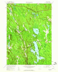
 1946 Otis1958 Print · USGSThe Berkshire highlands in the mid-1940s are defined here by a network of rural roads and water bodies centered on the expansive Otis Reservoir. Researchers can trace the layout of early communities through landmarks like the Beech Plain Sch, Norton Cem, and the historic Knox Trail.
 - 1948 Map of Otis
 1948 Otis1948 Print · USGSThe Berkshires in the late 1940s reveal a landscape of deep reservoirs and high summits like The Pinnacle. Local historians can trace family roots at West Center Cem or locate the old Beech Plain Sch near Cold Spring.2 unique versions available
 - 1948 Map of Albany, 1951 Print
 1948 Albany1951 Print · USGSThe Hudson and Connecticut River valleys are captured here in the late 1940s, showing the vital rail and water corridors of the Northeast. You can trace the Boston and Maine tracks past Mt Greylock or locate early settlements like Great Barrington and Bennington.
 - 1956 Map of Albany, 1968 Print
 1956 Albany1968 Print · USGSThe industrial heart of the Northeast is revealed in the mid-1950s, from the Hudson Valley to the Connecticut River. Researchers can trace the legacy of the Quabbin Reservoir, locate Westover Air Force Base, or follow the Rutland RR through the Green Mountains.2 unique versions available
 - 1957 Map of Albany
 1957 Albany1957 Print · USGSThe Tri-State region and Connecticut River Valley are captured here during a period of significant postwar growth and infrastructure expansion. Genealogists and historians can trace the rail-and-river economy through landmarks like the Boston and Maine railroad, Quabbin Reservoir, and Westover Air Force Base.
 - 1958 Map of Otis, 1960 Print
 1958 Otis1960 Print · USGSThe Berkshires in the late fifties center around the massive Otis Reservoir and its surrounding state forests. Researchers can trace old transportation routes including an Old Railroad Grade and find local landmarks like Norton Cem or Algerie Four Corners.2 unique versions available
 - 1959 Map of Albany
 1959 Albany1959 Print · USGSThe Hudson and Connecticut River valleys are captured here during the late fifties, showing the region's dense rail networks and massive water projects. Researchers can trace the New York State Thruway or locate local landmarks like Mt Greylock and the Quabbin Reservoir.
 - 1962 Map of Albany
 1962 Albany1962 Print · USGSThe Hudson and Connecticut River valleys meet the Green Mountains and Berkshires in this mid-century overview of the Northeast. Genealogists and historians can trace the industrial hearts of Albany and Springfield or locate features like Quabbin Reservoir and Westover Air Force Base.
 - 1973 Map of Otis, 1974 Print
 1973 Otis1974 Print · USGSThe southern Berkshire hills in the early 1970s show a landscape of expansive state forests and growing recreational hubs like the Otis Reservoir. Researchers can trace old transportation routes including an Old Railroad Grade or find family history at West Center Cem and Beech Plain Cem.2 unique versions available
 - 1975 Map of Otis, 1981 Print
 1975 Otis1981 Print · USGSThe Berkshire hills are captured in the mid-seventies through this aerial survey, showcasing a landscape of dense forests and large water bodies. Genealogists and researchers can trace the roads connecting Otis, East Otis, and Algerie Four Corners near the expansive Otis Reservoir.
 - 1986 Map of Pittsfield
 1986 Pittsfield1986 Print · USGSThe Berkshires and the Hudson Valley meet in the mid-1980s, documenting a cross-border landscape of mountain forests and river towns. Genealogists and historians can trace the paths of Conrail and the Taconic State Parkway as they pass through Stockbridge, Great Barrington, and Kinderhook.2 unique versions available
 - 1987 Map of Otis, 1988 Print
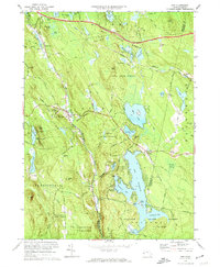
 1987 Otis1988 Print · USGSThe southern Berkshires in the late eighties show a landscape of expansive state forests and highland reservoirs. Researchers can locate Old Center Cem, the Appalachian Trail, and the secluded Hephzibah Heights settlement.
 - 1997 Map of Otis, 1999 Print
 1997 Otis1999 Print · USGSBerkshire County at the close of the twentieth century remains a landscape of deep forests and quiet hill towns. Researchers can trace the Appalachian Trail through Beartown State Forest or locate local landmarks like the Old Center Cem and Our Lady of the Hills Chapel.
 - 2012 Map of Otis, 2012 Print
 2012 Otis2012 Print · USGSCovers Algerie Four Corners, including Becket, Otis, and other nearby areas
 - 2015 Map of Otis, 2015 Print
 2015 Otis2015 Print · USGSCovers Algerie Four Corners, including Becket, Otis, and other nearby areas
 - 2018 Map of Otis, 2018 Print
 2018 Otis2018 Print · USGSCovers Algerie Four Corners, including Becket, Otis, and other nearby areas
 - 2021 Map of Otis, 2021 Print
 2021 Otis2021 Print · USGSCovers Algerie Four Corners, including Becket, Otis, and other nearby areas
 - 2024 Map of Otis, 2024 Print
 2024 Otis2024 Print · USGSThe Berkshire hills near the Hampden County line come into focus in this recent survey of the Otis area. Genealogists can locate family sites at Otis Center Cem and East Otis Cem, while tracing the waters of the Otis Reservoir and Big Pond.
End of results
Showing maps 1-25 of 25
Top cities near Algerie Four Corners
- Pittsfield historical maps
- Westfield historical maps
- Granby historical maps
- Southwick historical maps
- Great Barrington historical maps
- Dalton historical maps
See more
Frequently asked questions
- What are the different types of historical maps available for Algerie Four Corners?
- What is the oldest map of Algerie Four Corners?
- Where can I purchase historical maps of Algerie Four Corners for my home or office?
- Where can I download high-res historical maps of Algerie Four Corners?
- Are there historical topographic maps available for Algerie Four Corners?
- Is there historical aerial imagery available for Algerie Four Corners?
- Where are historical maps of Algerie Four Corners sourced from?