1970s Maps of Sheffield, Massachusetts
Explore 6 historic maps of Sheffield from the 1970s. These maps offer a rare glimpse into what life looked like during the 1970s — showing old roads, neighborhoods, homes, and landmarks that have changed or disappeared over time.
Whether you're researching your family's past, planning a metal detecting trip, or studying how Sheffield's landscape evolved across the 1970s, these high-resolution maps are a powerful tool for exploring the history of this region.
- Focus on a specific era: All maps on this page are from the 1970s, giving you a focused view of this time period.
- See what’s changed: Compare century-old streets, trails, and buildings to today's modern landscape using overlays and satellite layers.
- Research with precision: Use these maps for genealogy, historical research, land use analysis, or educational projects.
- View, download, or print: Maps are fully viewable online in high resolution, and can be downloaded or printed for your own records.
Start exploring Sheffield's history through authentic maps from the 1970s. This is your window into the past.
Sheffield, MA maps
(6)- 1973 Map of Great Barrington, 1974 Print
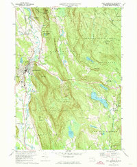 1973 Great Barrington1974 Print · USGSThe Housatonic Valley in the early seventies shows a maturing Berkshire landscape where industry, education, and recreation meet. Genealogists and hikers can trace the Appalachian Trail past Elmwood Cemetery and the Avalon School.3 unique versions available
 - 1973 Map of Egremont, 1974 Print
 1973 Egremont1974 Print · USGSThe Berkshires meet the New York border in the early 1970s, showcasing a landscape of mountain forests and valley settlements. Researchers can locate Simon's Rock Early College, trace the Appalachian Trail, and find the Battlesite Mon near South Egremont.4 unique versions available
 - 1975 Map of Ashley Falls, 1981 Print
 1975 Ashley Falls1981 Print · USGSThe Berkshire valley on the Connecticut border is shown in the mid-1970s, revealing the intricate meanders of the Housatonic River. Trace the rural road networks and field patterns connecting Ashley Falls, Sheffield, and Clayton.
 - 1975 Map of Bashbish Falls, 1981 Print
 1975 Bashbish Falls1981 Print · USGSThe tri-state border region comes into focus in the mid-1970s through this aerial orthophotograph of the Berkshires. Researchers can trace the layout of small communities like Joyceville and Taconic against the heights of Mt Everett and Bear Mtn.
 - 1975 Map of Egremont, 1981 Print
 1975 Egremont1981 Print · USGSThe rural Berkshire landscape of the mid-1970s is captured in this orthophoto, showing the agricultural heart of southwestern Massachusetts. Genealogists and local historians can trace property boundaries and land use around South Egremont, North Egremont, and Prospect Lake.
 - 1975 Map of Great Barrington, 1981 Print
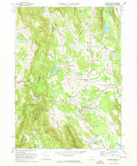
 1975 Great Barrington1981 Print · USGSThe Berkshires of the mid-seventies are captured in this aerial survey, revealing the densely wooded terrain and river-valley settlements of western Massachusetts. Researchers can trace the winding Housatonic River through Great Barrington or locate rural landmarks like Lake Buel and Hartsville.
End of results
Showing maps 1-6 of 6
Top cities near Sheffield
- Torrington historical maps
- Great Barrington historical maps
- Lee historical maps
- Ghent historical maps
- Lenox historical maps
- Salisbury historical maps
See more
Top neighborhoods of Sheffield
- East Sheffield historical maps
- Ashley Falls historical maps
- Sheffield Plain Historic District historical maps
Frequently asked questions
- What are the different types of historical maps available for Sheffield?
- What is the oldest map of Sheffield?
- Where can I purchase historical maps of Sheffield for my home or office?
- Where can I download high-res historical maps of Sheffield?
- Are there historical topographic maps available for Sheffield?
- Is there historical aerial imagery available for Sheffield?
- Where are historical maps of Sheffield sourced from?