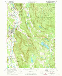
1973 Map of Great Barrington
USGS Topo · Published 1974About this map
The Housatonic River snakes through the western valley of this Berkshire County landscape, anchoring the principal settlements of Great Barrington and Berkshire Heights. By the early 1970s, the region’s character was defined by a mix of established industrial centers, education, and seasonal recreation. Infrastructure like the Penn Central railroad and Van Deusenville Road serviced local communities, while the Butternut Ski Area on the slopes of East Mountain State Forest signaled the area's growing draw for winter tourism.
Find a feature on this map
76 named features on this map. Tap any name to fly to it.
Don’t see what you’re looking for? This feature index may not catch every label — zoom into the map to look around manually.
Map Details
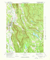
Editions of this 1973 Great Barrington Map
3 editions found

Other maps of this area

1885 · Sheffield
USGS Topo · 1:62,500

1886 · Becket
USGS Topo · 1:62,500

1888 · Sheffield
USGS Topo · 1:62,500

1888 · Becket
USGS Topo · 1:62,500

1888 · Sandisfield
USGS Topo · 1:62,500

1888 · Pittsfield
USGS Topo · 1:62,500

1890 · Pittsfield
USGS Topo · 1:62,500

1891 · Sheffield
USGS Topo · 1:62,500

1893 · Becket
USGS Topo · 1:62,500

1893 · Sheffield
USGS Topo · 1:62,500