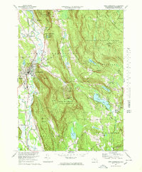
1973 Map of Great Barrington
USGS Topo · Published 1978About this map
The Housatonic River winds through this valley in the southern Berkshires, anchoring a landscape where industrial heritage and recreation converge. In the town of Great Barrington, the presence of the Penn Central railroad and a Limekiln near the Appalachian Trail reflects the area's long history of extraction and transport. To the east, the steep slopes of Beartown Mountain and the Beartown State Forest dominate the terrain, offering a stark contrast to the developed corridors of Risingdale and Van Deusenville.
Find a feature on this map
72 named features on this map. Tap any name to fly to it.
Don’t see what you’re looking for? This feature index may not catch every label — zoom into the map to look around manually.
Map Details
Editions of this 1973 Great Barrington Map
3 editions found
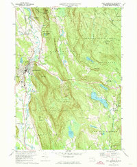

Other maps of this area

1885 · Sheffield
USGS Topo · 1:62,500

1886 · Becket
USGS Topo · 1:62,500

1888 · Sheffield
USGS Topo · 1:62,500

1888 · Becket
USGS Topo · 1:62,500

1888 · Sandisfield
USGS Topo · 1:62,500

1888 · Pittsfield
USGS Topo · 1:62,500

1890 · Pittsfield
USGS Topo · 1:62,500

1891 · Sheffield
USGS Topo · 1:62,500

1893 · Becket
USGS Topo · 1:62,500

1893 · Sheffield
USGS Topo · 1:62,500