1980s Maps of Westport, Massachusetts
Explore 5 historic maps of Westport from the 1980s. These maps offer a rare glimpse into what life looked like during the 1980s — showing old roads, neighborhoods, homes, and landmarks that have changed or disappeared over time.
Whether you're researching your family's past, planning a metal detecting trip, or studying how Westport's landscape evolved across the 1980s, these high-resolution maps are a powerful tool for exploring the history of this region.
- Focus on a specific era: All maps on this page are from the 1980s, giving you a focused view of this time period.
- See what’s changed: Compare century-old streets, trails, and buildings to today's modern landscape using overlays and satellite layers.
- Research with precision: Use these maps for genealogy, historical research, land use analysis, or educational projects.
- View, download, or print: Maps are fully viewable online in high resolution, and can be downloaded or printed for your own records.
Start exploring Westport's history through authentic maps from the 1980s. This is your window into the past.
Westport, MA maps
(5)- 1984 Map of Block Island
 1984 Block Island1984 Print · USGSThe coastal borderlands of Rhode Island, Connecticut, and New York are captured here in the mid-eighties, from the rail hubs of Westerly to the shores of Block Island. Genealogists and historians can trace the shoreline's evolution through landmarks like the Pequot Indian Res, New Shoreham, and Narragansett Pier.
 - 1984 Map of Sakonnet Point
 1984 Sakonnet Point1984 Print · USGSThe coastal border of Rhode Island and Massachusetts in the 1980s reveals a shoreline of wildlife refuges and rocky navigational hazards. Trace local landmarks like the Lighthouse (Abandoned) at Sakonnet Point, St Andrews by the Sea Ch, and the grounds of Woods Castle.
 - 1984 Map of Providence, 1985 Print
 1984 Providence1985 Print · USGSThe Rhode Island coast and its industrial heartlands are captured here in the mid-eighties, showing the density of the Providence metro area. Researchers can trace historic rail lines like the Providence & Worcester RR and explore the maritime layout of Narragansett Bay and Newport.
 - 1985 Map of Westport
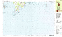
 1985 Westport1985 Print · USGSThe coastal border of Massachusetts and Rhode Island is meticulously detailed in the mid-1980s, showcasing a landscape of tidal inlets and colonial-era crossroads. Local researchers can trace old family footprints at Adamsville or find local landmarks like St Catherine Ch and the Westport Yacht Club.
 - 1985 Map of Fall River
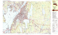 1985 Fall River1985 Print · USGSFall River and the surrounding Bristol County shorelines are captured here in the mid-1980s, showcasing the region's dense urban core and rural fringes. Researchers can locate specific community landmarks like Westport Factory, the Polish National Cem, and the Borden Flats Lighthouse.2 unique versions available
End of results
Showing maps 1-5 of 5
Top cities near Westport
- New Bedford historical maps
- Fall River historical maps
- Dartmouth historical maps
- Bristol historical maps
- Newport historical maps
- Somerset historical maps
See more
Top neighborhoods of Westport
- Camp Noquochoke historical maps
- Central Village historical maps
- Giffords Corner historical maps
- Handy Four Corners historical maps
- Kirby Corner historical maps
- Macombers Corner historical maps
See more
Frequently asked questions
- What are the different types of historical maps available for Westport?
- What is the oldest map of Westport?
- Where can I purchase historical maps of Westport for my home or office?
- Where can I download high-res historical maps of Westport?
- Are there historical topographic maps available for Westport?
- Is there historical aerial imagery available for Westport?
- Where are historical maps of Westport sourced from?