1950s Maps of Dukes County, Massachusetts
Explore 9 historic maps of Dukes County from the 1950s. These maps offer a rare glimpse into what life looked like during the 1950s — showing old roads, neighborhoods, homes, and landmarks that have changed or disappeared over time.
Whether you're researching your family's past, planning a metal detecting trip, or studying how Dukes County's landscape evolved across the 1950s, these high-resolution maps are a powerful tool for exploring the history of this region.
- Focus on a specific era: All maps on this page are from the 1950s, giving you a focused view of this time period.
- See what’s changed: Compare century-old streets, trails, and buildings to today's modern landscape using overlays and satellite layers.
- Research with precision: Use these maps for genealogy, historical research, land use analysis, or educational projects.
- View, download, or print: Maps are fully viewable online in high resolution, and can be downloaded or printed for your own records.
Start exploring Dukes County's history through authentic maps from the 1950s. This is your window into the past.
Dukes County, MA maps
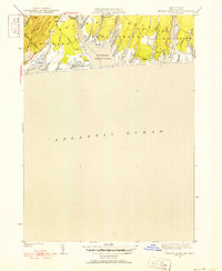
(9)- 1951 Map of Cuttyhunk
 1951 Cuttyhunk1951 Print · USGSThe Elizabeth Islands at mid-century offer a detailed view of maritime life between Buzzards Bay and Vineyard Sound. Trace the isolated settlement of Cuttyhunk, the grounds of the C G Sta, and natural landmarks like Saddleback Hill and Gosnold Pond.3 unique versions available
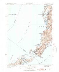
 - 1951 Map of Squibnocket
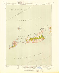
 1951 Squibnocket1951 Print · USGSThe western reaches of Martha's Vineyard are captured here in the early fifties, showing the area's transition from a remote fishing outpost to a summer retreat. Genealogists and historians can trace family-named sites like Abel Hill Brook and landmarks including Gay Head Lighthouse and Menemsha.5 unique versions available
 - 1951 Map of Edgartown
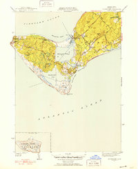
 1951 Edgartown1951 Print · USGSMartha's Vineyard at mid-century reveals a landscape of maritime tradition and coastal hamlets. Genealogists and island historians can trace old neighborhoods like Clevelandtown, find Oak Grove Cem, and locate the historic Edgartown Lighthouse.4 unique versions available
 - 1951 Map of Vineyard Haven
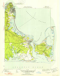
 1951 Vineyard Haven1951 Print · USGSMarthas Vineyard in the early fifties reveals a landscape of quiet coastal villages and expanding seasonal retreats. Researchers can trace the layout of Vineyard Haven or locate specific landmarks like the Lamberts Cove Ch and the West Chop Lighthouse.5 unique versions available
 - 1951 Map of Tisbury Great Pond
 1951 Tisbury Great Pond1951 Print · USGSThe southern coast of Martha's Vineyard is captured here in the early fifties, showing the rural shoreline of West Tisbury and Edgartown. Researchers can trace old island routes like Ridge Highway and locate family landmarks at Nabs Corner and Quansoo.5 unique versions available
 - 1953 Map of Woods Hole, 1954 Print
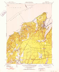
 1953 Woods Hole1954 Print · USGSThe Cape Cod coastline near Falmouth in the 1950s shows a maritime landscape of harbors and early vacation development. Genealogists and historians can trace the New Haven and Hartford RR line through Sippowisset or locate family plots at Crowell Cem.4 unique versions available
 - 1957 Map of Providence
 1957 Providence1957 Print · USGSCoastal New England at the height of the mid-century era shows a landscape shaped by maritime industry and Cold War defense. Genealogists and historians can trace the reach of the New York, New Haven & Hartford RR and locate legacy sites like Fort Adams and Quonset Point Naval Air Station.
 - 1957 Map of Falmouth, 1958 Print
 1957 Falmouth1958 Print · USGSCoastal Barnstable County comes alive in this mid-century portrait of established seaside villages and seasonal shorefront developments. Genealogists and historians can trace neighborhood growth through Waquoit Village, locate St Patricks Cath Ch, and find long-standing family Cranberry Bogs.3 unique versions available
 - 1958 Map of Providence
 1958 Providence1958 Print · USGSThe Rhode Island and Massachusetts coastlines are shown in detail during the late 1950s, from the urban cores to the tips of the islands. Researchers can trace the mid-century footprint of Quonset Point Naval Air Station, the defense works at Fort Adams, and the rail network of the New York, New Haven and Hartford RR.
End of results
Showing maps 1-9 of 9
Top cities of Dukes County
- Tisbury historical maps
- West Tisbury historical maps
- Oak Bluffs historical maps
- Chilmark historical maps
- Edgartown historical maps
- Aquinnah historical maps
See more
Frequently asked questions
- What are the different types of historical maps available for Dukes County?
- What is the oldest map of Dukes County?
- Where can I purchase historical maps of Dukes County for my home or office?
- Where can I download high-res historical maps of Dukes County?
- Are there historical topographic maps available for Dukes County?
- Is there historical aerial imagery available for Dukes County?
- Where are historical maps of Dukes County sourced from?