1940s Maps of Aquinnah, Massachusetts
Explore 7 historic maps of Aquinnah from the 1940s. These maps offer a rare glimpse into what life looked like during the 1940s — showing old roads, neighborhoods, homes, and landmarks that have changed or disappeared over time.
Whether you're researching your family's past, planning a metal detecting trip, or studying how Aquinnah's landscape evolved across the 1940s, these high-resolution maps are a powerful tool for exploring the history of this region.
- Focus on a specific era: All maps on this page are from the 1940s, giving you a focused view of this time period.
- See what’s changed: Compare century-old streets, trails, and buildings to today's modern landscape using overlays and satellite layers.
- Research with precision: Use these maps for genealogy, historical research, land use analysis, or educational projects.
- View, download, or print: Maps are fully viewable online in high resolution, and can be downloaded or printed for your own records.
Start exploring Aquinnah's history through authentic maps from the 1940s. This is your window into the past.
Aquinnah, MA maps
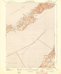
(7)- 1942 Map of Marthas Vineyard
 1942 Marthas Vineyard1942 Print · USGSMartha's Vineyard and the Elizabeth Islands appear here during the early years of the second World War. Researchers can trace historical lighthouse locations like Gay Head LH and Tarpaulin Cove LH, and explore the 1940s boundaries of Edgartown and Vineyard Haven.
 - 1944 Map of Naushon Island
 1944 Naushon Island1944 Print · USGSThe Elizabeth Islands and Marthas Vineyard are captured here during the Second World War as isolated coastal landscapes. Researchers can trace historic maritime landmarks like the Tarpaulin Cove Lighthouse and the topography of Ramshead Woods or Pasque Island.5 unique versions available
 - 1944 Map of Squibnocket
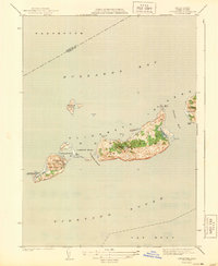
 1944 Squibnocket1944 Print · USGSThe western reaches of Martha's Vineyard are captured here during the early 1940s, showing a world of coastal ponds and fishing villages. Genealogists and historians can trace the paths between Lobsterville and Chilmark, or locate family landmarks near Abel Hill and Menemsha.3 unique versions available
 - 1944 Map of Cuttyhunk
 1944 Cuttyhunk1944 Print · USGSThe Elizabeth Islands at the height of the Second World War reveal a quiet but strategically vital maritime landscape. Researchers can trace the coastal layout of Cuttyhunk village, identify the Cuttyhunk Lighthouse, and locate the Coast Guard Station.2 unique versions available
 - 1947 Map of Providence, 1948 Print
 1947 Providence1948 Print · USGSSouthern New England is captured in the mid-1940s, showing a landscape defined by busy industrial ports and expanding military installations. Researchers can trace the rail lines of the N.Y. N.H. & H. RR or locate coastal defenses like Fort Adams and Quonset Point.5 unique versions available
 - 1948 Map of Providence, 1951 Print
 1948 Providence1951 Print · USGSSouthern New England’s coastal reaches are captured here in the late 1940s, from the industrial heart of Providence to the tip of Provincetown. Genealogists and historians can trace rail lines like the Central Vermont Railway and locate active military sites such as Otis Air Force Base and Fort Rodman.
 - 1949 Map of Naushon Island, 1958 Print
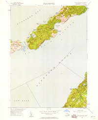 1949 Naushon Island1958 Print · USGSThe Elizabeth Islands and Marthas Vineyard are shown here in the late 1940s, when remote coastal roads and private woods still dominated the landscape. Trace the maritime history of Tarpaulin Cove Lighthouse and landmarks like Jobs Neck or West Beach.2 unique versions available
End of results
Showing maps 1-7 of 7
Top cities near Aquinnah
- Dartmouth historical maps
- Falmouth historical maps
- Westport historical maps
- Mattapoisett historical maps
- Tisbury historical maps
- West Tisbury historical maps
See more
Top neighborhoods of Aquinnah
Frequently asked questions
- What are the different types of historical maps available for Aquinnah?
- What is the oldest map of Aquinnah?
- Where can I purchase historical maps of Aquinnah for my home or office?
- Where can I download high-res historical maps of Aquinnah?
- Are there historical topographic maps available for Aquinnah?
- Is there historical aerial imagery available for Aquinnah?
- Where are historical maps of Aquinnah sourced from?