Old Maps of Aquinnah, Massachusetts for Hiking & Exploration
Hike through history with 38 historic maps of Aquinnah. Explore old trails, ghost towns, and forgotten backroads — perfect for outdoor adventurers and local explorers.
- Rediscover forgotten places: Map out old mining camps, roads, and footpaths that no longer exist on modern maps.
- Layer with modern tools: Combine with LiDAR or satellite views to plan hikes through historical terrain.
- Made for exploration: Popular among hikers, overlanders, and local history lovers.
Use these maps to find adventure and explore the hidden past of Aquinnah.
Aquinnah, MA maps
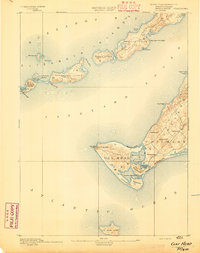
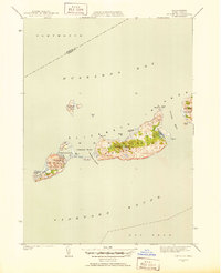
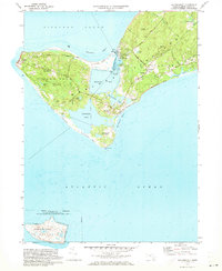
(38)- 1887 Map of Gay Head
 1887 Gay Head1887 Print · USGSThe islands of Dukes County appear in their late nineteenth-century character, spanning from the heights of Chilmark to the chain of the Elizabeth Islands. Genealogists and historians can trace family-named sites and coastal landmarks like Gay Head Light, the settlement of Squibnocket, and Tarpaulin Cove.
 - 1889 Map of Gay Head
 1889 Gay Head1889 Print · USGSThe western end of Martha's Vineyard and the Elizabeth Islands appear here in the late nineteenth century, defined by a maritime economy of lighthouses and small coastal settlements. Researchers can trace historic landmarks like Gay Head Light, Chilmark, and the remote No Mans Land.
 - 1893 Map of Gay Head
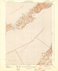
 1893 Gay Head1893 Print · USGSThe islands of Marthas Vineyard and the Elizabeth Islands appear here in the late nineteenth century. Researchers can trace the coastal geography of Chilmark, the prominent Gay Head Light, and the isolated reaches of Cuttyhunk Island and No Mans Land.7 unique versions available
 - 1942 Map of Marthas Vineyard
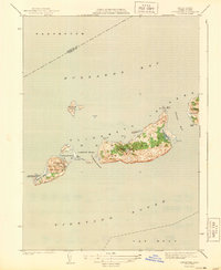
 1942 Marthas Vineyard1942 Print · USGSMartha's Vineyard and the Elizabeth Islands appear here during the early years of the second World War. Researchers can trace historical lighthouse locations like Gay Head LH and Tarpaulin Cove LH, and explore the 1940s boundaries of Edgartown and Vineyard Haven.
 - 1944 Map of Naushon Island
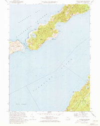
 1944 Naushon Island1944 Print · USGSThe Elizabeth Islands and Marthas Vineyard are captured here during the Second World War as isolated coastal landscapes. Researchers can trace historic maritime landmarks like the Tarpaulin Cove Lighthouse and the topography of Ramshead Woods or Pasque Island.5 unique versions available
 - 1944 Map of Squibnocket
 1944 Squibnocket1944 Print · USGSThe western reaches of Martha's Vineyard are captured here during the early 1940s, showing a world of coastal ponds and fishing villages. Genealogists and historians can trace the paths between Lobsterville and Chilmark, or locate family landmarks near Abel Hill and Menemsha.3 unique versions available
 - 1944 Map of Cuttyhunk
 1944 Cuttyhunk1944 Print · USGSThe Elizabeth Islands at the height of the Second World War reveal a quiet but strategically vital maritime landscape. Researchers can trace the coastal layout of Cuttyhunk village, identify the Cuttyhunk Lighthouse, and locate the Coast Guard Station.2 unique versions available
 - 1947 Map of Providence, 1948 Print
 1947 Providence1948 Print · USGSSouthern New England is captured in the mid-1940s, showing a landscape defined by busy industrial ports and expanding military installations. Researchers can trace the rail lines of the N.Y. N.H. & H. RR or locate coastal defenses like Fort Adams and Quonset Point.5 unique versions available
 - 1948 Map of Providence, 1951 Print
 1948 Providence1951 Print · USGSSouthern New England’s coastal reaches are captured here in the late 1940s, from the industrial heart of Providence to the tip of Provincetown. Genealogists and historians can trace rail lines like the Central Vermont Railway and locate active military sites such as Otis Air Force Base and Fort Rodman.
 - 1949 Map of Naushon Island, 1958 Print
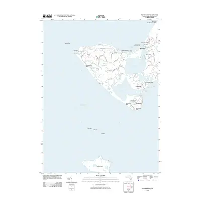
 1949 Naushon Island1958 Print · USGSThe Elizabeth Islands and Marthas Vineyard are shown here in the late 1940s, when remote coastal roads and private woods still dominated the landscape. Trace the maritime history of Tarpaulin Cove Lighthouse and landmarks like Jobs Neck or West Beach.2 unique versions available
 - 1951 Map of Cuttyhunk
 1951 Cuttyhunk1951 Print · USGSThe Elizabeth Islands at mid-century offer a detailed view of maritime life between Buzzards Bay and Vineyard Sound. Trace the isolated settlement of Cuttyhunk, the grounds of the C G Sta, and natural landmarks like Saddleback Hill and Gosnold Pond.3 unique versions available
 - 1951 Map of Squibnocket
 1951 Squibnocket1951 Print · USGSThe western reaches of Martha's Vineyard are captured here in the early fifties, showing the area's transition from a remote fishing outpost to a summer retreat. Genealogists and historians can trace family-named sites like Abel Hill Brook and landmarks including Gay Head Lighthouse and Menemsha.5 unique versions available
 - 1957 Map of Providence
 1957 Providence1957 Print · USGSCoastal New England at the height of the mid-century era shows a landscape shaped by maritime industry and Cold War defense. Genealogists and historians can trace the reach of the New York, New Haven & Hartford RR and locate legacy sites like Fort Adams and Quonset Point Naval Air Station.
 - 1958 Map of Providence
 1958 Providence1958 Print · USGSThe Rhode Island and Massachusetts coastlines are shown in detail during the late 1950s, from the urban cores to the tips of the islands. Researchers can trace the mid-century footprint of Quonset Point Naval Air Station, the defense works at Fort Adams, and the rail network of the New York, New Haven and Hartford RR.
 - 1963 Map of Providence
 1963 Providence1963 Print · USGSSouthern New England's coastal and industrial heartland is captured here in the early sixties, from the Rhode Island mainland to the far reaches of the Cape. Researchers can trace mid-century growth in Providence or locate landmarks on Marthas Vineyard and Nantucket Island.
 - 1972 Map of Cuttyhunk, 1973 Print
 1972 Cuttyhunk1973 Print · USGSThe Elizabeth Islands at the start of the seventies reveal a remote maritime landscape centered on the village of Cuttyhunk. Researchers can trace old coastal landmarks like the Lighthouse, the local Cem, and the topography of Nashawena Island.3 unique versions available
 - 1972 Map of Naushon Island, 1973 Print
 1972 Naushon Island1973 Print · USGSThe Elizabeth Islands and Martha's Vineyard are captured here in the early seventies, detailing the secluded terrain and maritime heritage of Dukes County. Trace historical landmarks like the Tarpaulin Cove Lighthouse, the French Watering Place, and the wooded trails of Naushon Island.3 unique versions available
 - 1972 Map of Squibnocket, 1973 Print
 1972 Squibnocket1973 Print · USGSMartha's Vineyard in the early seventies shows the tranquil fishing villages and ancestral lands of Gay Head and Chilmark. Genealogists and historians can trace family ties at the Indian Burying Ground and Gay Head Cem, or locate the isolated Navy target range on Nomans Land.3 unique versions available
 - 1977 Map of Cuttyhunk, 1981 Print
 1977 Cuttyhunk1981 Print · USGSThe Elizabeth Islands are seen in detail during the late 1970s, showing the remote maritime landscape of Dukes County. Trace the settlement of Cuttyhunk and the coastal contours of Nashawena Island and Penikese Island.
 - 1977 Map of Naushon Island, 1981 Print
 1977 Naushon Island1981 Print · USGSThe Elizabeth Islands are captured in detail during the late seventies, showing the coastal transition between Buzzards Bay and the sound. Trace the shoreline of Naushon Island, locate Mt Surat, and see the extent of Westend Pond.
 - 1977 Map of Squibnocket, 1981 Print
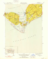
 1977 Squibnocket1981 Print · USGSThe western tip of Marthas Vineyard is captured in this late-seventies aerial survey, showing the coastal landscape in photographic detail. Trace the development of Gay Head and Chilmark, or see the isolation of Nomans Land and Menemsha.
 - 1986 Map of Martha's Vineyard
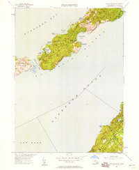
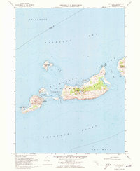
 1986 Martha's Vineyard1986 Print · USGSThe Massachusetts islands of the mid-eighties appear in detail, showing the settled towns and wild coastlines before modern development shifts. Researchers can trace land use through the Martha's Vineyard State Forest or find old roads in Siasconset and Clevelandtown.
 - 1994 Map of Martha's Vineyard
 1994 Martha's Vineyard1994 Print · USGSThe islands of Martha's Vineyard and Nantucket are captured here in the mid-nineties, showing the established coastal villages and extensive conservation lands. Researchers can trace the boundaries of Manuel F Correllus State Forest or locate landmarks like the Lighthouse at Gay Head and Chappaquiddick Island.
 - 2012 Map of Squibnocket, 2012 Print
 2012 Squibnocket2012 Print · USGSCovers Aquinnah, including Chilmark, Nashaquitsa, and other nearby areas
 - 2012 Map of Naushon Island, 2012 Print
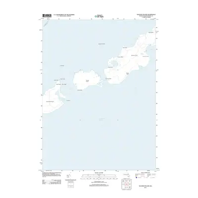 2012 Naushon Island2012 Print · USGSCovers Aquinnah, including West Tisbury, Chilmark, and other nearby areas
Showing maps 1-25 of 38
Top cities near Aquinnah
- Dartmouth historical maps
- Falmouth historical maps
- Westport historical maps
- Mattapoisett historical maps
- Tisbury historical maps
- West Tisbury historical maps
See more
Top neighborhoods of Aquinnah
Frequently asked questions
- What are the different types of historical maps available for Aquinnah?
- What is the oldest map of Aquinnah?
- Where can I purchase historical maps of Aquinnah for my home or office?
- Where can I download high-res historical maps of Aquinnah?
- Are there historical topographic maps available for Aquinnah?
- Is there historical aerial imagery available for Aquinnah?
- Where are historical maps of Aquinnah sourced from?