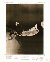
1977 Map of Cuttyhunk
USGS Topo · Published 1981About this map
The southern end of the Elizabeth Islands archipelago is captured here via orthophotography, providing a clear visual record of the shoreline and land cover in the late 1970s. The settlement of Cuttyhunk is visible on the eastern end of Cuttyhunk Island, serving as the primary hub of human activity between Buzzards Bay and Vineyard Sound. This aerial perspective highlights the distinct geography of the outlying islands, including the smaller Penikese Island to the north and the larger, more elongated Nashawena Island to the east. The transition from the developed village area of Cuttyhunk to the open, low-lying landscapes of Pasque Island illustrates the isolated maritime character of this corner of Massachusetts. Genealogists and historians can use this imagery to study the footprints of island dwellings and the natural state of the land before modern changes.
Find a feature on this map
8 named features on this map. Tap any name to fly to it.
Don’t see what you’re looking for? This feature index may not catch every label — zoom into the map to look around manually.
Map Details
Editions of this 1977 Cuttyhunk Map
This is the sole edition of this map. No revisions or reprints were ever made.
Other maps of this area

1885 · New Bedford
USGS Topo · 1:62,500

1887 · Gay Head
USGS Topo · 1:62,500

1888 · New Bedford
USGS Topo · 1:62,500

1889 · Gay Head
USGS Topo · 1:62,500

1893 · Gay Head
USGS Topo · 1:62,500

1893 · New Bedford
USGS Topo · 1:62,500

1918 · New Bedford
USGS Topo · 1:62,500
1936 · South Dartmouth
USGS Topo · 1:24,000
1940 · Sconticut Neck
USGS Topo · 1:31,680
1941 · New Bedford South
USGS Topo · 1:31,680