1800s (19th Century) Maps of Chilmark, Massachusetts
Explore 6 historic maps of Chilmark from the 1800s (19th Century). These maps offer a rare glimpse into what life looked like during the 1800s — showing old roads, neighborhoods, homes, and landmarks that have changed or disappeared over time.
Whether you're researching your family's past, planning a metal detecting trip, or studying how Chilmark's landscape evolved across the 1800s, these high-resolution maps are a powerful tool for exploring the history of this region.
- Focus on a specific era: All maps on this page are from the 1800s, giving you a focused view of this time period.
- See what’s changed: Compare century-old streets, trails, and buildings to today's modern landscape using overlays and satellite layers.
- Research with precision: Use these maps for genealogy, historical research, land use analysis, or educational projects.
- View, download, or print: Maps are fully viewable online in high resolution, and can be downloaded or printed for your own records.
Start exploring Chilmark's history through authentic maps from the 1800s. This is your window into the past.
Chilmark, MA maps
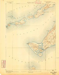
(6)- 1887 Map of Gay Head
 1887 Gay Head1887 Print · USGSThe islands of Dukes County appear in their late nineteenth-century character, spanning from the heights of Chilmark to the chain of the Elizabeth Islands. Genealogists and historians can trace family-named sites and coastal landmarks like Gay Head Light, the settlement of Squibnocket, and Tarpaulin Cove.
 - 1887 Map of Marthas Vineyard
 1887 Marthas Vineyard1887 Print · USGSMartha's Vineyard in the late nineteenth century remains a landscape of maritime commerce and quiet island life. Genealogists can trace family names and early settlements from Cottage City and Edgartown to the rural roads of West Tisbury.
 - 1889 Map of Gay Head
 1889 Gay Head1889 Print · USGSThe western end of Martha's Vineyard and the Elizabeth Islands appear here in the late nineteenth century, defined by a maritime economy of lighthouses and small coastal settlements. Researchers can trace historic landmarks like Gay Head Light, Chilmark, and the remote No Mans Land.
 - 1889 Map of Marthas Vineyard
 1889 Marthas Vineyard1889 Print · USGSThe eastern shores of the Vineyard come alive in the late Victorian era, showcasing the early growth of Cottage City and Edgartown. Genealogists and historians can trace old road networks connecting West Tisbury to the coast and locate historic beacons like West Chop Light.
 - 1893 Map of Gay Head
 1893 Gay Head1893 Print · USGSThe islands of Marthas Vineyard and the Elizabeth Islands appear here in the late nineteenth century. Researchers can trace the coastal geography of Chilmark, the prominent Gay Head Light, and the isolated reaches of Cuttyhunk Island and No Mans Land.7 unique versions available
 - 1894 Map of Marthas Vineyard, 1898 Print
 1894 Marthas Vineyard1898 Print · USGSMartha's Vineyard in the 1890s appears as a land of maritime necessity and early coastal villages. Genealogists can trace family settlements in Vineyard Haven and Edgartown or locate lighthouses like West Chop Light and Cape Poge Light.7 unique versions available
End of results
Showing maps 1-6 of 6
Top cities near Chilmark
- Dartmouth historical maps
- Falmouth historical maps
- Tisbury historical maps
- West Tisbury historical maps
- Oak Bluffs historical maps
- Edgartown historical maps
See more
Top neighborhoods of Chilmark
- Squibnocket historical maps
- Nashaquitsa historical maps
- Nabs Corner historical maps
- Quansoo historical maps
- Menemsha historical maps
Frequently asked questions
- What are the different types of historical maps available for Chilmark?
- What is the oldest map of Chilmark?
- Where can I purchase historical maps of Chilmark for my home or office?
- Where can I download high-res historical maps of Chilmark?
- Are there historical topographic maps available for Chilmark?
- Is there historical aerial imagery available for Chilmark?
- Where are historical maps of Chilmark sourced from?