1970s Maps of Jerneganville, Edgartown
Explore 2 historic maps of Jerneganville from the 1970s. These maps offer a rare glimpse into what life looked like during the 1970s — showing old roads, neighborhoods, homes, and landmarks that have changed or disappeared over time.
Whether you're researching your family's past, planning a metal detecting trip, or studying how Jerneganville's landscape evolved across the 1970s, these high-resolution maps are a powerful tool for exploring the history of this region.
- Focus on a specific era: All maps on this page are from the 1970s, giving you a focused view of this time period.
- See what’s changed: Compare century-old streets, trails, and buildings to today's modern landscape using overlays and satellite layers.
- Research with precision: Use these maps for genealogy, historical research, land use analysis, or educational projects.
- View, download, or print: Maps are fully viewable online in high resolution, and can be downloaded or printed for your own records.
Start exploring Jerneganville's history through authentic maps from the 1970s. This is your window into the past.
Jerneganville, Edgartown maps
(2)- 1972 Map of Edgartown, 1973 Print
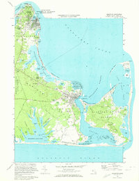 1972 Edgartown1973 Print · USGSMartha's Vineyard in the early seventies shows a landscape of storied harbor towns and quiet coastal ponds. Trace family heritage at the Tower Hill Burying Ground or explore the shores of Chappaquiddick Island and Sengekontacket Pond.3 unique versions available
 - 1977 Map of Edgartown, 1981 Print
 1977 Edgartown1981 Print · USGSMartha's Vineyard in the late seventies is shown in this aerial orthophoto, documenting the island's eastern shores and villages. Trace the streets of Edgartown, the layout of Oak Bluffs, and the rural character of Chappaquiddick Island.
End of results
Showing maps 1-2 of 2
Top cities near Jerneganville
- Falmouth historical maps
- Mashpee historical maps
- Mattapoisett historical maps
- Tisbury historical maps
- Osterville historical maps
- West Tisbury historical maps
See more
Frequently asked questions
- What are the different types of historical maps available for Jerneganville?
- What is the oldest map of Jerneganville?
- Where can I purchase historical maps of Jerneganville for my home or office?
- Where can I download high-res historical maps of Jerneganville?
- Are there historical topographic maps available for Jerneganville?
- Is there historical aerial imagery available for Jerneganville?
- Where are historical maps of Jerneganville sourced from?